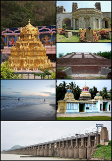
Krishna district is one of the nine districts in the Coastal Andhra region of the Indian state of Andhra Pradesh. Machilipatnam is the administrative headquarters and Vijayawada is the most populated city in the district. It has an area of 8,727 km2 (3,370 sq mi) and had a population of 4,529,009 as per 2011 census of India. It is bounded by West Godavari on the east, Bay of Bengal on the South, Guntur and Suryapet districts in the west and a portion of it also borders with the state of Telangana.
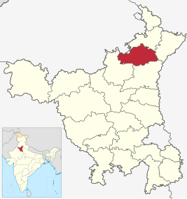
Kurukshetra district is one of the 22 districts of Haryana state in northern India. The town of Kurukshetra, a sacred place for the Hindus, is the administrative headquarters of this district. The district occupies an area of 1530.00 km². The district has a population of 964,655. This district is part of Ambala division. Kurukshetra is also the land of Srimad Bhagawad Gita. Jyotisar is the place in Kurukshetra where Krishna is believed to deliver the sermon of Gita to Arjuna in the Mahabharata.
Vatsavai is a village in Krishna district of the Indian state of Andhra Pradesh. It is located in Vatsavai mandal of Vijayawada revenue division.

Mylavaram is a Town in Krishna district of the Indian state of Andhra Pradesh. It is located in Mylavaram mandal of Vijayawada revenue division. Mylavaram village has higher literacy rate compared to Andhra Pradesh.In 2011, literacy rate of Mylavaram village was 76.49% compared to 67.02% of Andhra Pradesh.

Kuligod is a village in the southern state of Karnataka, India. It is located in the Gokak taluk of Belgaum district in Karnataka.
Saptasagar is a village in the southern state On River Bank of Krishna Karnataka, State India. It is located in the Athani taluk of Belgaum district in Karnataka.
Soundatti is a village in the southern state of Karnataka, India. It is located in the Raybag taluk of Belgaum district in Karnataka.
Krishna-kittur is a village in the southern state of Karnataka, India. It is located in the Athani taluka of Belgaum district in Karnataka.

Chandarlapadu mandal is one of the 50 mandals in Krishna District of the Indian state of Andhra Pradesh. It is under the administration of Vijayawada revenue division and headquarters located at Chandarlapadu. The mandal is situated on the banks of Krishna River, bounded by Jaggayyapeta, Nandigama, Kanchikacherla mandals.

Vuyyuru mandal is one of the 50 mandals in Krishna district of the Indian state of Andhra Pradesh. It is under the administration of Nuzvid revenue division and the headquarters are located at Vuyyuru town. The mandal is bounded by Kankipadu, Unguturu, Thotlavalluru, Pedaparupudi and Pamidimukkala mandals. The mandal is also a part of the Andhra Pradesh Capital Region under the jurisdiction of APCRDA.

Machilipatnam mandal is one of the 50 mandals in Krishna district of the Indian state of Andhra Pradesh. It is under the administration of Machilipatnam revenue division and the headquarters are located at Machilipatnam town. The mandal is bounded by Bantumilli, Pedana, Gudur, Ghantasala, Challapalli and Koduru mandals.

Ibrahimpatnam mandal is one of the fifty mandals that constitute the Krishna district of the State of Andhra Pradesh in India. It is under the administration of the Vijayawada revenue division and the mandal headquarters are located at Ibrahimpatnam town. The mandal is located on the banks of Krishna River and is bounded by Kanchikacherla, Veerullapadu, G. Konduru and Vijayawada (rural) mandals. The mandal is also a part of the Andhra Pradesh Capital Region under the jurisdiction of APCRDA.

Nagayalanka mandal is one of the 50 mandals in Krishna district of the Indian state of Andhra Pradesh. It is under the administration of Machilipatnam revenue division and has its headquarters at Nagayalanka. The mandal is bounded by Avanigadda and Koduru mandals. It lies at the mouths of Krishna River where it empties into Bay of Bengal.

Jaggayyapeta mandal is one of the 50 mandals in Krishna district of the state of Andhra Pradesh in India. It is under the administration of Vijayawada revenue division and the headquarters are located at Jaggayyapeta town. Krishna River flows through the mandal and is bounded by Penuganchiprolu, Nandigama, Chandarlapadu mandals of Krishna district, some part of Guntur district, Nalgonda and Khammam districts of Telangana.

Mopidevi mandal is one of the 50 mandals in Krishna district of the Indian state of Andhra Pradesh. It is under the administration of Machilipatnam revenue division and the headquarters are located at Mopidevi. The mandal is bounded by Challapalli, Koduru and Avanigadda mandals.
Avanigadda mandal is one of the 50 mandals in Krishna district of the Indian state of Andhra Pradesh. It is under the administration of Machilipatnam revenue division and the headquarters are located at Avanigadda. The mandal is bounded by Mopidevi, Koduru and Nagayalanka mandals.
Kanchikacherla mandal is one of the 50 mandals in Krishna district of the Indian state of Andhra Pradesh. It is under the administration of Vijayawada revenue division and the headquarters are located at Kanchikacherla. The mandal is bounded Veerullapadu, Chanderlapadu and Ibrahimpatnam mandals. A portion of it lies on the banks of Krishna river, separating it from Guntur district and also Munneru river separates it from Nandigama mandal.

Pamarru Mandal is one of the 50 Mandals in Krishna district of the Indian state of Andhra Pradesh. It is under the administration of Gudivada revenue division and the headquarters are located at Pamarru. The mandal is bounded by Pamidimukkala, Pedaparupudi, Movva, Gudur, Gudlavalleru and Gudivada Mandals of Krishna District.

Krishna Chandrapur is a census town and a gram panchayat within the jurisdiction of the Mathurapur police station in the Mathurapur I CD block in the Diamond Harbour subdivision of the South 24 Parganas district in the Indian state of West Bengal.

