
The Vale of Glamorgan, often referred to as The Vale, is a county borough in the south-east of Wales. It borders Bridgend County Borough to the west, Cardiff to the east, Rhondda Cynon Taf to the north, and the Bristol Channel to the south. With an economy based largely on agriculture and chemicals, it is the southernmost unitary authority in Wales. Attractions include Barry Island Pleasure Park, the Barry Tourist Railway, Medieval wall paintings in St Cadoc's Church, Llancarfan, Porthkerry Park, St Donat's Castle, Cosmeston Lakes Country Park and Cosmeston Medieval Village. The largest town is Barry. Other towns include Penarth, Llantwit Major, and Cowbridge. There are many villages in the county borough.

The Bristol Channel is a major inlet in the island of Great Britain, separating South Wales and South West England. It extends from the smaller Severn Estuary of the River Severn to the North Atlantic Ocean. It takes its name from the English city and port of Bristol

The Taff Vale Railway (TVR) was a standard gauge railway in South Wales, built by the Taff Vale Railway Company to serve the iron and coal industries around Merthyr Tydfil and to connect them with docks in Cardiff. It was opened in stages in 1840 and 1841.

Cardiff Bay is an area and freshwater lake in Cardiff, Wales. The site of a former tidal bay and estuary, it is the river mouth of the River Taff and Ely. The body of water was converted into a 500-acre (2.0 km2) lake as part of a UK Government redevelopment project, involving the damming of the rivers by the Cardiff Bay Barrage in 1999. The barrage impounds the rivers from the Severn Estuary, providing flood defence and the creation of a permanent non-tidal high water lake with limited access to the sea, serving as a core feature of the redevelopment of the area in the 1990s.

Penarth is a town and community in the Vale of Glamorgan, Wales, approximately 3 miles (4.8 km) south of Cardiff city centre on the west shore of the Severn Estuary at the southern end of Cardiff Bay.

Kidwelly is a town and community in Carmarthenshire, southwest Wales, approximately 7 miles (11 km) northwest of the most populous town in the county, Llanelli. In the 2001 census the community of Kidwelly returned a population of 3,289, increasing to 3,523 at the 2011 Census.

Atlantic Wharf is a southern area of the city of Cardiff, Wales. It is primarily an area of new houses and apartments located on the west side of the disused Bute East Dock and to the east of Lloyd George Avenue. It also includes a number of refurbished dock warehouses, modern hotels, the Red Dragon Centre and Cardiff Council's County Hall. Atlantic Wharf lies in the Butetown electoral division of Cardiff and the Cardiff South and Penarth constituency for the UK Parliament and the Senedd.

Lavernock is a hamlet in the Vale of Glamorgan in Wales, lying on the coast 7 miles (11 km) south of Cardiff between Penarth and Sully, and overlooking the Bristol Channel.

Cadoxton railway station is a railway station serving Cadoxton and Palmerstown near Barry, Vale of Glamorgan, South Wales. It is located on the Barry Branch 6½ miles (10 km) south of Cardiff Central. The line continues to the terminus of the Barry Branch at Barry Island but from Barry Junction the line also continues as the Vale of Glamorgan branch to Bridgend via Rhoose for Cardiff International Airport bus link and then Llantwit Major.

Penarth Marina is both a marina for boats, located in the old Penarth Docks, Wales and also the name generally used to describe the surrounding area of modern housing. The marina is adjacent to the waters of the River Ely and Cardiff Bay, close to the Cardiff Bay Barrage.

Barry Docks is a port facility in the town of Barry, Vale of Glamorgan, Wales, a few miles southwest of Cardiff on the north shore of the Bristol Channel. The docks were opened in 1889 by David Davies and John Cory as an alternative to the congested and expensive Cardiff Docks to ship coal carried by rail from the South Wales Coalfield. The principal engineer was John Wolfe Barry, assisted by Thomas Forster Brown and Henry Marc Brunel, son of the famous engineer Isambard Kingdom Brunel.
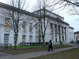
The Bute Building is a Cardiff University building in Cathays Park, Cardiff, Wales. It houses the Welsh School of Architecture. It is a Grade II listed building.
The A496 is a major coastal and mountainous road in southern Snowdonia.
A bibliography of books related to the Vale of Glamorgan, south Wales.

St Augustine's Church is a Grade I-listed Gothic Revival nineteenth-century parish church in Penarth, Vale of Glamorgan, Wales.
Penarth Dock railway station served the docks area of Penarth.
Curran Steels was a manufacturing company in Cardiff, Wales, founded as the Edward Curran Engineering Co and known locally as Curran's.

National Cycle Route 88 is a route of the National Cycle Network, running from Newport to its planned finish site at Margam.


