Related Research Articles
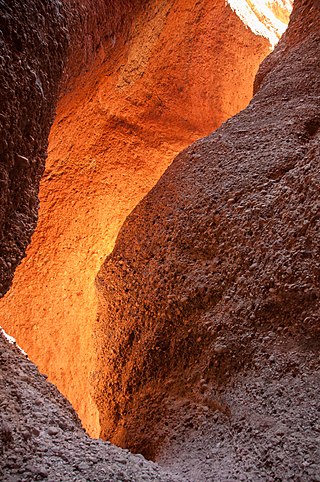
The Purnululu National Park is a World Heritage Site in the East Kimberley region of Western Australia. The 239,723-hectare (592,370-acre) national park is located approximately 300 kilometres (190 mi) south of Kununurra, with Halls Creek located to the south. Declared a World Heritage Site in 2003, the park was inscribed as follows:
...[is a] remote area managed as wilderness. It includes the Bungle Bungle Range, a spectacularly incised landscape of sculptured rocks which contains superlative examples of beehive-shaped karst sandstone rising 250 metres above the surrounding semi-arid savannah grasslands. Unique depositional processes and weathering have given these towers their spectacular black and orange banded appearance, formed by biological processes of cyanobacteria which serve to stabilise and protect the ancient sandstone formations. These outstanding examples of cone karst that have eroded over a period of 20 million years are of great beauty and exceptional geological interest.

The Murchison River is the second longest river in Western Australia. It flows for about 820 km (510 mi) from the southern edge of the Robinson Ranges to the Indian Ocean at Kalbarri. The Murchison-Yalgar-Hope river system is the longest river system in Western Australia. It has a mean annual flow of 208 gigalitres, although in 2006, the peak year on record since 1967, flow was 1,806 gigalitres.
The Western Australian Museum is a statutory authority within the Culture and the Arts Portfolio, established under the Museum Act 1969.

The City of Perth is a local government area and body, within the Perth metropolitan area, which is the capital of Western Australia. The local government is commonly known as Perth City Council. The City covers the Perth city centre and surrounding suburbs. The City covers an area of 20.01 square kilometres (8 sq mi) and had an estimated population of 21,092 as at 30 June 2015. On 1 July 2016 the City expanded, absorbing 1,247 residents from the City of Subiaco.
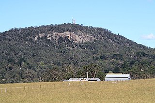
Mount Gibraltar is a mountain with an elevation of 863 metres (2,831 ft) AHD that is located in the Southern Highlands region, between Bowral and Mittagong, in New South Wales, Australia. Further west is Berrima.

The Shire of Mount Marshall is a local government area in the Wheatbelt region of Western Australia, about 80 kilometres (50 mi) north-northwest of Merredin and about 300 kilometres (186 mi) northeast of the state capital, Perth. The Shire covers an area of 10,190 square kilometres (3,934 sq mi), and its seat of government is the town of Bencubbin.

The Shire of Boddington is a local government area in the Peel region of Western Australia, about 120 kilometres (75 mi) south-east of the state capital, Perth. The Shire covers an area of 1,901 square kilometres (734 sq mi), and its seat of government is the town of Boddington.
The Shire of Toodyay is a local government area in the Wheatbelt region of Western Australia, beyond the north-eastern limits of the Perth metropolitan area. The Shire covers an area of 1,694 square kilometres (654 sq mi), and its seat of government is the town of Toodyay.

The Shire of Kojonup is a local government area in the Great Southern region of Western Australia, about 250 kilometres (155 mi) southeast of the state capital, Perth, along Albany Highway. The Shire covers an area of 2,932 square kilometres (1,132 sq mi) and its seat of government is the town of Kojonup.

The Shire of Shark Bay is a local government area of Western Australia in the Gascoyne region. It has an area of 25,423 km2 and a population of about 950. It is made up of two peninsulas and Shark Bay, located at the westernmost point of Australia. There is one town in the Shire of Shark Bay, Denham, which is the administrative centre for the Shire. There are also a number of small communities; they are Useless Loop, Monkey Mia, Nanga and Hamelin Pool. The Overlander and The Billabong are roadhouses.

The Shire of Northampton is a local government area in the Mid West region of Western Australia, about 50 kilometres (30 mi) north of Geraldton and about 460 kilometres (290 mi) north of the state capital, Perth. The Shire covers an area of 13,738 square kilometres (5,304 sq mi), and its seat of government is the town of Northampton, with the largest settlement being Kalbarri.

The Shire of Sandstone is a local government area in the eastern Mid West region of Western Australia, about 740 kilometres (460 mi) northeast of the state capital, Perth. The Shire covers an area of 32,882 square kilometres (12,696 sq mi), and its seat of government is the town of Sandstone.
The Z Bend lookout is a popular tourist lookout on the Murchison River Gorge in Western Australia. It is located at 27°39′19″S114°27′19″E, about 30 kilometres (19 mi) east of Kalbarri, in the Kalbarri National Park. One of four lookouts in the national park, it is situated on a sharp bend in the gorge. The view includes an excellent section through the Tumblagooda Sandstone, a geological sequence of fluvial and coastal deposits over one kilometre (0.62 mi) deep.
Shell House is an area of coastal cliffs located between Red Bluff and Bluff Point in Kalbarri National Park in Mid West Western Australia. They are highly regarded for their scenery, and also for the exposures of geological strata, which include Ordovician Tumblagooda sandstone, Triassic Wittecarra sandstone and Kockatea shale. The Shell House cliffs have been listed on Australia's Register of the National Estate since 1978.
Murchison River Gorge is a riverine gorge in Mid West Western Australia. Carved by the meandering lower reaches of the Murchison River, it is more than 80 kilometres (50 mi) long, and up to 129 metres (423 ft) deep. It begins about 13.5 kilometres (8.4 mi) north-northwest of Ajana, and extends to the mouth of the river at Kalbarri.
Stone Wall is an escarpment overlooking the Murchison River Gorge about 16 kilometres (9.9 mi) north-east of Kalbarri in Mid West Western Australia. It is of geological interest because it provides outstanding exposures of five Cretaceous formations unconformably overlying the Ordovician Tumblagooda sandstone. The Cretaceous formations contain trace fossils of Skolithos and Cylindricum. It has been visited on geological excursions and is considered an important research site.
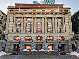
The General Post Office is a heritage landmark building in Perth, Western Australia. Located on the western side of Forrest Place in the city's central business district, its imposing stone facade is in the Beaux-Arts style. The building was completed in 1923 after almost a decade of construction, which was protracted by World War I and the resulting shortages of construction materials. At the time of its opening, it was the largest building in Perth.

Bridge Street is a street in the central business district of Sydney, Australia. Bridge Street runs for 500 metres (1,600 ft) in a west–east direction with traffic flowing in both directions. It is situated in the northern portion of the central business district. The western terminus of Bridge Street is at George Street, with the eastern terminus at Macquarie Street, adjacent to the Chief Secretary's Building. From west to east, Bridge Street crosses Pitt and Phillip streets.
References
- ↑ Hocking, Roger Malcolm (1991). The Silurian Tumblagooda Sandstone, Western Australia. Perth, WA: Geological Survey of Western Australia. p. 78. ISBN 9780730909873.
- ↑ "Pencell Pool Geological Monument, Coolcalalaya Rd, Galena via Ajana, WA, Australia (Place ID 19080)". Australian Heritage Database . Australian Government . Retrieved 19 December 2016.
- ↑ "Pencell Pool/10 Mile Pool". InHerit. Heritage Council of Western Australia . Retrieved 19 December 2016.
| | This article about a specific Australian geological feature is a stub. You can help Wikipedia by expanding it. |
| | This article about a location in Western Australia is a stub. You can help Wikipedia by expanding it. |