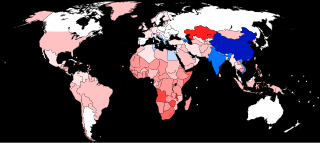
The human sex ratio is the ratio of males to females in a population in the context of anthropology and demography. In humans, the natural sex ratio at birth is slightly biased towards the male sex. It is estimated to be about 1.05 or 1.06 or within a narrow range from 1.03 to 1.06 males per female.
Thorapalli or Thorapalli Agraharam is a village in Hosur taluk, Krishnagiri district, Tamil Nadu. It is located on the banks of the Ponnaiyar river about 6 km south-east of Hosur close to the Hosur-Krishnagiri road, about 50 kilometres from Bangalore. It is the birthplace of C. Rajagopalachari, the last Governor-General of India and second chief minister of Madras State.
Goraganamudi is a village located near Bhimavaram, West Godavari district, Andhra Pradesh. Nuclear Physicist Swami Jnanananda was born in this image. Pennada Agrhrm Railway Station and Vendra Railway Station are nearest train stations.
Ganapathy agraharam is a village in the Papanasam taluk of Thanjavur district, Tamil Nadu, India.
Sarabhojirajapuram is a village in the Papanasam taluk of Thanjavur district, Tamil Nadu, India. The village was established as an agraharam by the Thanjavur Maratha ruler Serfoji I.
Palayee Agraharam is a village in the Pattukkottai taluk of Thanjavur district, Tamil Nadu, India.
Bobbili is one of the 34 mandals in Vizianagaram district of Andhra Pradesh, India. Bobbili town is the headquarters of the mandal. The mandal is bounded by Makkuva, Seethanagaram, Balajipeta, Salur, Ramabhadrapuram, Badangi and Therlam mandals.

Duggirala mandal is one of the 18 mandals in Guntur district of the Indian state of Andhra Pradesh. It is under the administration of Tenali revenue division and the headquarters are located at Duggirala. The mandal is bounded by Mangalagiri, Pedakakani, Tenali and Kollipara mandals. Krishna River lies to the northeast of the Duggirala mandal.
Nizampatnam mandal is one of the 25 mandals in Bapatla district of the state of Andhra Pradesh, India. It is under the administration of Repalle Revenue Division and the headquarters are located at Nizampatnam. The mandal is bounded by Repalle, Nagaram, Pittalavanipalem and Karlapalem mandals. The mandals lies on the shore of Bay of Bengal and a portion of the mandal lies on the banks of Krishna River.
Naidupeta mandal is one of the 34 mandals in Tirupati district of the state of Andhra Pradesh, India. Its headquarters are located at Naidupeta. The mandal is bounded by Balayapalle, Ojili, Pellakur, Doravarisatram and Chittamur mandals.
Narasaraopet mandal is one of the 28 mandals in Guntur district of the India state of Andhra Pradesh. It is under the administration of Narasaraopet revenue division and the headquarters are located at Narasaraopet city. The mandal is bounded by Rompicherla, Nekarikallu, Muppalla, Phirangipuram, Nadendla and Chilakaluripeta. It also borders Prakasam district.
Renigunta mandal is one of the 34 mandals in Tirupati district of the Indian state of Andhra Pradesh. Its headquarters are located at Renigunta, suburb of Tirupati.. The mandal is bounded by Tirupati (urban), Tirupati (rural), Vadamalapeta, Yerpedu.This mandal is located at Srikalahasti revenue division.

Atchampet mandal is one of the 28 mandals in Palnadu district of the Indian state of Andhra Pradesh. The mandal is under the administration of Sattenapalli revenue division and the headquarters are located at Chamarru. The mandal is located on the banks of Krishna River, at a distance 68 km from the district headquarters. It is bounded by Amaravathi, Krosuru, Pedakurapadu, Bellamkonda and Sattenapalli mandals.
Palacoderu mandal is one of the 19 mandals in the West Godavari district of the Indian state of Andhra Pradesh. The headquarters are located at Palacoderu town. The mandal is bordered by Veeravasaram mandal to the north, Bhimavaram mandal to the east, Undi mandal to the south and Attili mandal to the west.
Kotananduru mandal is one of the 21 mandals in Kakinada District of Andhra Pradesh. As per census 2011, there are 14 villages.
Thondangi mandal is one of the 21 mandals in Kakinada district of Andhra Pradesh. As per census 2011, there are 15 villages.
Pithapuram mandal is one of the 21 mandals in Kakinada district of Andhra Pradesh. As per census 2011, there are 1 town and 22 villages.
Rowthulapudi Mandal is one of the 21 mandals in Kakinada District of Andhra Pradesh. As per census 2011, there are 38 villages.
Ramachandrapuram Mandal is one of the 22 mandals in Dr. B.R. Ambedkar Konaseema district of Andhra Pradesh. As per census 2011, there are 1 town 20 villages.
Amalapuram mandal is one of the 22 mandals in Dr. B.R. Ambedkar Konaseema district of Andhra Pradesh. As per census 2011, there are 17 villages in this mandal.


