Related Research Articles

The Allegheny River is a 325 mi (523 km) long headwater stream of the Ohio River in western Pennsylvania and New York. The Allegheny River runs from its headwaters just below the middle of Pennsylvania's northern border northwesterly into New York then in a zigzag southwesterly across the border and through Western Pennsylvania to join the Monongahela River at the Forks of the Ohio on the "Point" of Point State Park in Downtown Pittsburgh, Pennsylvania. The Allegheny River is, by volume, the main headstream of both the Ohio and Mississippi Rivers. Historically, the Allegheny was considered to be the upper Ohio River by both Native Americans and European settlers.

The Monongahela River —often referred to locally as the Mon —is a 130-mile-long (210 km) river on the Allegheny Plateau in north-central West Virginia and Southwestern Pennsylvania. The river flows from the confluence of its west and east forks in north-central West Virginia northeasterly into southwestern Pennsylvania, then northerly to Pittsburgh and its confluence with the Allegheny River to form the Ohio River. The river's entire length is navigable via a series of locks and dams.

The Allegheny Portage Railroad was the first railroad constructed through the Allegheny Mountains in central Pennsylvania. It operated from 1834 to 1854 as the first transportation infrastructure through the gaps of the Allegheny that connected the midwest to the eastern seaboard across the barrier range of the Allegheny Front. Approximately 36 miles (58 km) long overall, both ends connected to the Pennsylvania Canal, and the system was primarily used as a portage railway, hauling river boats and barges over the divide between the Ohio and the Susquehanna Rivers. Today, the remains of the railroad are preserved within the Allegheny Portage Railroad National Historic Site operated by the National Park Service.

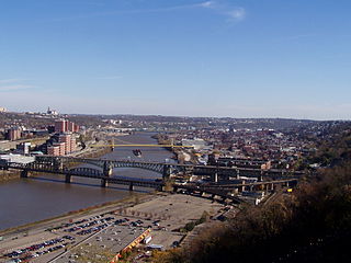
Downtown Pittsburgh, colloquially referred to as the Golden Triangle, and officially the Central Business District, is the urban downtown center of Pittsburgh. It is located at the confluence of the Allegheny River and the Monongahela River whose joining forms the Ohio River. The triangle is bounded by the two rivers.

The Great Allegheny Passage (GAP) is a 150-mile (240 km) rail trail between Pittsburgh, Pennsylvania and Cumberland, Maryland. Together with the C&O Canal towpath, the GAP is part of a 335 mi (539 km) route between Pittsburgh and Washington, D.C., that is popular with through hikers and cyclists.
Livermore, Pennsylvania is an abandoned town that was located on the Conemaugh River between Blairsville and Saltsburg in Derry Township, Westmoreland County, Pennsylvania. The town was abandoned and partially razed in the early 1950s following authorization by the Flood Control Act of 1936 and Flood Control Act of 1938 for construction of the Conemaugh Dam and Lake to prevent flooding of Pittsburgh. Much of the former town site now lies under the reservoir and floodplains.

The Main Line of Public Works was a package of legislation passed by the Commonwealth of Pennsylvania in 1826 to establish a means of transporting freight between Philadelphia and Pittsburgh. It funded the construction of various long-proposed canal and road projects, mostly in southern Pennsylvania, that became a canal system and later added railroads. Built between 1826 and 1834, it established the Pennsylvania Canal System and the Allegheny Portage Railroad.

The Genesee Valley Canal is a former canal that operated in central New York between 1840 and 1878. It ran for a length of 124 miles, passing through 106 locks. Its course was later used by the Genesee Valley Canal Railroad and today comprises portions of the Genesee Valley Greenway.
The Schuylkill Canal, or Schuylkill Navigation, was a system of interconnected canals and slack-water pools along the Schuylkill River in the U.S. state of Pennsylvania, built as a commercial waterway in the early 19th-century. Chartered in 1815, the navigation opened in 1825 to provide transportation and water power. At the time, the river was the least expensive and most efficient method of transporting bulk cargo, and the eastern seaboard cities of the U.S. were experiencing an energy crisis due to deforestation. It fostered the mining of anthracite coal as the major source of industry between Pottsville and eastern markets. Along the tow-paths, mules pulled barges of coal from Port Carbon through the water gaps to Pottsville; locally to the port and markets of Philadelphia; and some then by ship or through additional New Jersey waterways, to New York City markets.

The Monongahela Incline is a funicular located near the Smithfield Street Bridge in Pittsburgh, Pennsylvania. Designed and built by Prussian-born engineer John Endres in 1870, it is the oldest continuously operating funicular in the United States.
The Liberty Bridge, completed in 1928, connects downtown Pittsburgh, Pennsylvania, to the Liberty Tunnels and the South Hills neighborhoods beyond. It crosses the Monongahela River and intersects Interstate 579 at its northern terminus.

The Ohio Connecting Railroad Bridge is a steel bridge which crosses the Ohio River at Brunot's Island at the west end of Pittsburgh, Pennsylvania, United States. It consists of two major through truss spans over the main and back channels of the river, of 508 feet (155 m) and 406 feet (124 m) respectively, with deck truss approaches.

Pittsburgh, surrounded by rivers and hills, has a unique transportation infrastructure that includes roads, tunnels, bridges, railroads, inclines, bike paths, and stairways.
The Union Railroad is a Class III switching railroad located in Allegheny County in Western Pennsylvania. The company is owned by Transtar, Inc., which is itself a subsidiary of Fortress Transportation and Infrastructure Investors, after being purchased from United States Steel in 1988. The railroad's primary customers are the three plants of the USS Mon Valley Works, the USS Edgar Thomson Steel Works, the USS Irvin Works and the USS Clairton Works.

The Pittsburgh Light Rail is a 26.2-mile (42.2 km) light rail system in Pittsburgh, Pennsylvania, and surrounding suburbs. It operates as a deep-level subway in Downtown Pittsburgh, but runs mostly at-grade in the suburbs south of the city. The system is largely linear in a north-south direction, with one terminus just north of Pittsburgh's central business district and two termini in the South Hills. The system is owned and operated by Pittsburgh Regional Transit. It is the successor system to the streetcar network formerly operated by Pittsburgh Railways, the oldest portions of which date to 1903. The Pittsburgh light rail lines are vestigial from the city's streetcar days, and is one of only three light rail systems in the United States that continues to use the Pennsylvania Trolley (broad) gauge rail on its lines instead of 4 ft 8+1⁄2 instandard gauge. Pittsburgh is one of the few North American cities that have continued to operate light rail systems in an uninterrupted evolution from the first-generation streetcar era, along with Boston, Cleveland, New Orleans, Newark, Philadelphia, San Francisco and Toronto. In 2021, the system had a ridership of 27,975,600.

The Port Perry Branch is a rail line owned and operated by the Norfolk Southern Railway in the U.S. state of Pennsylvania. The line runs from the Pittsburgh Line in North Versailles Township southwest through the Port Perry Tunnel and across the Monongahela River on the PRR Port Perry Bridge to the Mon Line in Duquesne along a former Pennsylvania Railroad line.
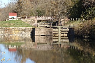
The Pennsylvania Canal was a complex system of transportation infrastructure improvements including canals, dams, locks, tow paths, aqueducts, and viaducts. The Canal and Works were constructed and assembled over several decades beginning in 1824, the year of the first enabling act and budget items. It should be understood the first use of any railway in North America was the year 1826, so the newspapers and the Pennsylvania Assembly of 1824 applied the term then to the proposed rights of way mainly for the canals of the Main Line of Public Works to be built across the southern part of Pennsylvania.

The Wabash Tunnel is a former railway tunnel and presently an automobile tunnel through Mt. Washington in the city of Pittsburgh, Pennsylvania, United States. Constructed early in the 20th century by railroad magnate George J. Gould for the Wabash Railroad, it was closed to trains and cars between 1946 and 2004.

Brownsville Road is a road between Pittsburgh, at Eighteenth Street and South Avenue in Allegheny County, Pennsylvania eastwards through Mount Oliver and generally highlands situated along or near the hilltops often overlooking the Monongahela River. It has had several names over its history, and was also known at the Red Stone Road and the period it was a Plank Road managed as a toll road, the Brownsville Plank Road, or the Brownsville Turnpike, or locally, as the area grew into a city, Southern Avenue.

Port Perry was a town along the Monongahela River near Braddock, Pennsylvania and by the mouth of Turtle Creek. It disappeared by 1945, having been gradually replaced by railroad tracks serving the nearby Edgar Thomson Steel Works.
References
- 1 2 3 Van Atta, Robert B. (21 April 2002). "Past 25 years have seen much progress in preservation of local history". Pittsburgh Tribune-Review . Pittsburgh. Retrieved 28 December 2009.
- ↑ Hazard, Samuel (1828). Register of Pennsylvania. Vol. 2. Philadelphia: W.F. Geddes. p. 338. OCLC 1751903 . Retrieved 27 December 2009.
- ↑ Miller, Ralph. "Tunnel Unearthed, City Past Floats Back." Pittsburgh, Pennsylvania: The Pittsburgh Press, December 10, 1967, p. 29 (subscription required).
- ↑ "Pennsylvania Canal, Marvel of Its Age, Swelled City's Trade." Pittsburgh, Pennsylvania: The Pittsburgh Press, January 18, 1959, p. 96 (subscription required).
- ↑ Fleming, George T. "Slow Canal Travel Marked a Long Step in Pennsylvania's Progress." Pittsburgh, Pennsylvania: Pittsburgh Post-Gazette, September 23, 1917, p. 33 (subscription required).
- ↑ Baer, Christopher T. (April 2005) [1827]. A GENERAL CHRONOLOGY OF THE PENNSYLVANIA RAILROAD COMPANY ITS PREDECESSORS AND SUCCESSORS AND ITS HISTORICAL CONTEXT (PDF) (April 2005 ed.).
- ↑ Feikema, Robert J. (May 16, 1999). "The canal that made Pittsburgh great". Pittsburgh Post Gazette.
- ↑ Pittsburgh, 1758-2008. Images of America. Carnegie Library of Pittsburgh. Charleston, SC: Arcadia. 2008. p. 18.
it continued to the Monongahela River, partly through a short-lived tunnel under Grant's Hill.
{{cite book}}: CS1 maint: others (link) - ↑ Nicklin, Philip Holbrook (1836). A pleasant peregrination through the prettiest parts of Pennsylvania (digitized book). Philadelphia: Grigg and Elliott. p. 106.
- ↑ "Two Canals" (PDF). New York Times . 15 October 1904.
- ↑ Pennsylvania Supreme Court (1862). "Munn and Barton versus The Mayor, &c, of Pittsburgh". Pennsylvania state reports. Vol. 40. pp. 364–372.
- Pittsburgh Tribune-Review; January 13, 2008