Pensacola Pass

Last updated
Perdidorivermap.png
Diamond sheer black 20.png


Pensacola Pass
Location of Pensacola Pass in Florida Panhandle, at the Gulf of Mexico.
USA Florida location map.svg
Red pog.svg
Location of Pensacola Pass in Florida, at the Gulf of Mexico.

Pensacola Pass is an inlet between Santa Rosa Island and Perdido Key at the western end of the Florida Panhandle. It connects the Gulf of Mexico to Pensacola Bay. The mainland around Pensacola Bay is heavily developed, with high-rise condominiums. Santa Rosa Island and the eastern part of Perdido Key adjacent to Pensacola Pass are units of the Gulf Islands National Seashore, and remain largely undeveloped.

Contents

Description

Pensacola Pass is an inlet between the barrier islands of Santa Rosa Island and Perdido Key connecting the Gulf to Pensacola Bay. Ships and boats use this passage to travel between the two.

During the daily flood tide, fresh saltwater enters Pensacola Pass from the Gulf of Mexico; waters are pulled out on the ebb tide, flushing the bay. The pass is located in the Floridian counties of Escambia and Santa Rosa. It is protected from devastating ocean waves by the Fairpoint peninsula as well as a barrier island, Santa Rosa, from which the county gets its name. The pass itself is about 21 kilometers long and 4 kilometers wide.

History

There is little evidence of human presence around Pensacola Pass before the arrival of Europeans in the area. A Fort Walton culture archaeological site has been identified on Perdido Key, and other archaeological sites may be present, but hurricanes have greatly disturbed and even destroyed such sites on the barrier islands. [1] The Pensacola area was first explored by Europeans in the 16th century. Diego Miruelo found a bay on the north coast of the Gulf of Mexico in 1516 that some authors think was Pensacola Bay. [2]

The Narváez expedition in 1528 may have encountered the Pensacola people in the vicinity of Pensacola Bay. Cabeza de Vaca reported that the Indians they encountered in the vicinity of what is now Pensacola Bay were of "large stature and well formed," and lived in permanent houses. The cacique wore a robe of what de Vaca called "civet-marten", "the best [skins], I think, that can be found." After initially appearing to be friendly, the Indians attacked the Spaniards without warning during the night. [3] [4]

Hernando de Soto sent one of his captains, Francisco Maldonando, to find a harbor on the coast west of Apalachee Province that could be used to resupply his expedition. Maldonado selected Pensacola Bay, which he called "Ochuse" after the native name for the land there. [5]

The first Spanish settlement in Pensacola was founded in 1559 by the explorer Tristan de Luna y Arenallo. He named it the “Bahia Santa Maria de Filipina.” With 1400 people arriving in 11 ships from Mexico, this was the first European settlement in what is now the United States. The colony was later nearly obliterated by a hurricane and the survivors abandoned it in 1561. It was concluded that Florida might be too dangerous to colonize. It was left alone for 135 years.

In 1693, Mexican Viceroy Gaspar de Sandoval Silva, Count of Galve, sent a small crew to inspect the gulf coast from north of the Pensacola bay to the mouth of the Mississippi (the Pensacola Pass). In order to see if the land was adequate for a settlement, they brought the renowned scientist and historian Carlos de Singuenza who renamed the bay “Santa Maria de Galve.” He authored a report that claimed the land was more than hospitable, it was a paradise. In 1698, a settlement was created by the Pensacola Pass that was used as a buffer against the French-owned Louisiana. Andres de Arriola was governor and found the conditions in Florida to be much more harsh than Siguenza had described.

The Spanish had become allies against the English in an attempt to try to prevent them from taking over the Southeast. However, in 1719, it was the French who took Pensacola with a fleet of ships and allied native warriors. The Spanish garrison commander wasn't even aware that a war had begun, so he had no choice but to surrender the fort with the conditions that the Spanish could continue living in the city, and the military men could return to a different fort. Another hurricane hit in 1722, so the French left the city, burning it, so it could not be taken back by the Spanish. The local Spanish created a new city, this time on the mainland instead of the barrier island (Santa Rosa) so it could be protected from large waves and severe weather.

-                 The Spanish (1722-1763)

-                 British West Florida (1763-1781)

-                 The Spanish (1781-1819)

The War of 1812 caused a power shift near the Pensacola Pass. The Spanish holdings in America were weakened, so the United States ended up taking over the area and created a navy yard and 3 forts around Pensacola. [6]

American era

Shortly after acquiring Florida from Spain, three forts were built to defend the inlet. Fort Barrancas was built on the mainland, Fort Pickens on Santa Rosa Island, and Fort McRee of Foster's Bank (now the eastern end of Perdido Key). Fort McRee was damaged in the Civil War and abandoned after the war. It eventually fell into the inlet as the island eroded away.

In the 1890s, shore batteries for the defense of Pensacola Bay were built at Forts Barrancas and Pickens and on Foster's Bank (Perdido Key), west of the ruins of the mid-19th century Fort McRee. The batteries were completed in 1900 and deactivated after the end of World War I. Construction of new defenses for Pensacola Bay started in 1940, with new batteries built at the three forts. Those batteries were deactivated when World War II ended in 1945. The ruins of batteries Center, Slemmer, and 233 on Perdido Key are preserved in the Perdido Key Historic District. [7] [8]

Migration and dredging

Pensacola Pass is shifting westward due to longshore drift. The westward flowing longshore current accretes sand on the western end of Santa Rosa Island and erodes sand from eastern end of Perdido Key. The site of the original Fort McRee, built in 1830 on the eastern end of Perdido Key, was in the channel in the middle of Pensacola Pass by 1979. Pensacola Pass has been dredged since 1883 to maintain a channel into Pensacola Bay for United States Navy and other ships. The dredging has interrupted the natural transport of sand across the inlet from Santa Rosa Island to Perdido Key, with the result that Pensacola Pass is a net sediment sink. This has starved the eastern half of Perdido Key of sand, leading to the erosion of that part of the island. The easternmost part of the island is receiving sand dredged from the inlet in a beach nourishment project. [9] [10] [11]

2010 Gulf oil spill

Following the Deepwater Horizon oil spill (called the "Gulf oil spill"), the entrance to Pensacola Pass was closed, [12] with a floating barrier system in June 2010, to control tidal flow of oil entering from the Gulf of Mexico. The daily high tide was causing oil-contaminated water to enter Pensacola Bay. The barrier system was to be designed to allow boats to travel through Pensacola Pass during the ebb tide, but to close during the rising tide.

Although this was the initial plan, the booming plan was never fully implemented. Due to strong currents in the Pass, the boom broke. There was no alternative system in place in areas of less current, nor was there a plan to trap incoming oil, therefore oil product freely entered the Pass. [13]

Post-Oil Spill

The beaches in Pensacola were Ground Zero for the oil spill. Within two weeks of making landfall, the spill had taken over the Pensacola Pass. The Gulf Oil Spill killed local wildlife and devastated the ecosystem. Fish that didn't die were still inedible, so seafood restaurants suffered. The beaches were blackened, and tourism was devastated. Tourism was the main source of income for the area, so the economy was crippled in what many called a “lost summer.” [14]

Research shows that the major metropolitan areas between Pensacola and Panama City lost around $150 million combined per month in the months of June, July, August and September 2010. Bear in mind that 2010 was the tail end of the recession, so unemployment was already up to 10%. That summer, businesses reported 50%-80% drops in revenue. [14]

BP Oil agreed to pay millions in settlements to local environmental efforts and economic development. This helped rejuvenate the tourist industry which skyrocketed, going from $5.4 million in 2010 to $12.3 million in 2019. [14]

Aftermath

Recent research shows that beaches affected by the spill may take over 30 years to biodegrade. [15] However, local governments are working with volunteers to clean up the Pensacola beaches. In 2019, there were 447 petroleum cleanup sites managed with 28 sites being successfully cleaned up and closed. [16] Major protests continue for the burning of fossil fuels, such as oil, and spreading awareness of Climate Change. Days after the oil hit shore, President Obama visited the Panama beaches and claimed that there would be “unprecedented federal response” to the historic environmental disaster.

In response to the Deepwater Horizon incident, Escambia county, which received 97% of the oil in Florida and 52 miles of the shore oiled, passed the RESTORE Act (Resources and Ecosystems Sustainability, Tourist Opportunities and Revived Economies Act). [17] The Act states that penalty money received from the parties responsible for the oil spill will be used to protect the environment and economy of the Gulf Coast region. Other programs not under the RESTORE Act, such as the Natural Resources Damage Assessment or the National Fish and Wildlife Foundation were still funded separately through the oil spill fines.

Other Environmental Hazards in Pensacola

Pensacola recently ranked No. 12 in the United States for toxic releases per square mile. With pollution from industrial plants, landfills, septic tanks and more, the Pensacola area and Escambia county are in harsh conditions.

Pollution got so bad, in fact, that in 1999 there was a special grand jury assembled to assess local air and water quality. This jury found that local regulators had been failing their task of diminishing pollution. Major corporate industries were finding loopholes in regulations or managed to convince local governments to relax them. The grand jury ultimately issued 27 specific recommendations on how the county can protect its natural resources, but many believe that these suggestions are still being ignored. [18]

Pensacola has had multiple other major environmental disasters as well. There was the Saufley Field Landfill fire, where waste with certain toxicity levels was burnt. The fire produced hazardous gasses and particulate matter.[ [18] This fire burnt for 4 months in 2005 and 2006. In 2017, there was the International Paper spill explosion that launched sticky black debris all over neighborhoods.

Related Research Articles

<span class="mw-page-title-main">Santa Rosa County, Florida</span> County in Florida, United States

Santa Rosa County is a county located in the northwestern portion of the U.S. state of Florida. As of 2020, the population is 188,000. The county seat is Milton, which lies in the geographic center of the county. Other major communities within Santa Rosa County are Navarre, Pace, and Gulf Breeze. Navarre is the most populated community with a population of approximately 45,000 residents. Santa Rosa County is included in the Pensacola Metropolitan Statistical Area, which also includes Escambia County.

<span class="mw-page-title-main">Pensacola, Florida</span> City in Florida, United States

Pensacola is the westernmost city in the Florida Panhandle, and the county seat and only incorporated city of Escambia County, Florida. Pensacola is the principal city of the Pensacola Metropolitan Area, which had an estimated 502,629 residents in 2019. At the 2020 United States census, the population was 54,312.

<span class="mw-page-title-main">Destin, Florida</span> City in Florida, United States

Destin is a city located in Okaloosa County, Florida, United States. It is a principal city of the Crestview–Fort Walton Beach–Destin metropolitan area.

<span class="mw-page-title-main">Pensacola Beach, Florida</span> Unincorporated Community in Florida, United States

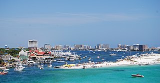
Pensacola Beach is an unincorporated community located on Santa Rosa Island, a barrier island, in Escambia County, Florida, United States. It is situated south of Pensacola in the Gulf of Mexico. As of the 2000 census, the community had a total population of 2,738. It has been described as "famous" for its ultra-white sand beaches.
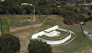
<span class="mw-page-title-main">Fort Pickens</span> Historic United States military fort on Santa Rosa Island, Pensacola, Florida

Fort Pickens is a pentagonal historic United States military fort on Santa Rosa Island in the Pensacola, Florida, area. It is named after American Revolutionary War hero Andrew Pickens. The fort was completed in 1834 and was one of the few forts in the South that remained in Union hands throughout the American Civil War. It remained in use until 1947. Fort Pickens is included within the Gulf Islands National Seashore, and as such, is administered by the National Park Service.

<span class="mw-page-title-main">Fort McRee</span> Former fort near Pensacola, Florida

Fort McRee was a historic military fort constructed by the United States on the eastern tip of Perdido Key to defend Pensacola and its important natural harbor. In the defense of Pensacola Bay, Fort McRee was accompanied by Fort Pickens, located across Pensacola Pass on Santa Rosa Island, and Fort Barrancas, located across Pensacola Bay on the grounds of what is now Naval Air Station (NAS) Pensacola. Fort Pickens was the largest of these. Very little remains of Fort McRee today.

<span class="mw-page-title-main">Florida Panhandle</span> Northwest region of Florida

The Florida Panhandle is the northwestern part of the U.S. state of Florida. It is a salient roughly 200 miles long, bordered by Alabama on the north and the west, Georgia on the north, and the Gulf of Mexico to the south. Its eastern boundary is arbitrarily defined. It is defined by its southern culture and rural geography relative to the rest of Florida, as well as closer cultural links to French-influenced Louisiana, Mississippi, and Alabama. Its major communities include Pensacola, Navarre, Destin, Panama City Beach, and Tallahassee.

<span class="mw-page-title-main">Santa Rosa Island (Florida)</span> Island of Pensacola in Florida, United States

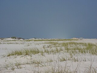
Santa Rosa Island is a 40-mile (64 km) barrier island located in the U.S. state of Florida, thirty miles (50 km) east of the Alabama state border. The communities of Pensacola Beach, Navarre Beach, and Okaloosa Island are located on the island. On the northern side of the island, are Pensacola Bay on the west and Choctawhatchee Bay on the east, joined through Santa Rosa Sound.

<span class="mw-page-title-main">Emerald Coast</span> Region in Florida, United States

The Emerald Coast is an unofficial name for the coastal area in the US state of Florida on the Gulf of Mexico that stretches about 100 miles (160 km) through five counties, Escambia, Santa Rosa, Okaloosa, Walton, and Bay, which include Pensacola Beach, Navarre Beach, Fort Walton Beach, Destin, and Panama City Beach. Some south Alabama communities on the coast of Baldwin County, such as Gulf Shores, Orange Beach, and Fort Morgan embrace the term as well.

<span class="mw-page-title-main">Gulf Islands National Seashore</span> 96,000 underwater acres in Mississippi and Florida (US) managed by the National Park Service

Gulf Islands National Seashore is an American National seashore that offers recreation opportunities and preserves natural and historic resources along the Gulf of Mexico barrier islands of Florida and Mississippi. In 2022, it was the eighth-most visited unit of the National Park Service.

<span class="mw-page-title-main">Fort Barrancas</span> United States historic place

Fort Barrancas (1839) or Fort San Carlos de Barrancas is a United States military fort and National Historic Landmark in the former Warrington area of Pensacola, Florida, located physically within Naval Air Station Pensacola, which was developed later around it.

<span class="mw-page-title-main">Perdido Key, Florida</span> Unincorporated community in Florida, United States

Perdido Key is an unincorporated community in Escambia County, Florida located between Pensacola, Florida and Orange Beach, Alabama. The community is located on and named for Perdido Key, a barrier island in northwest Florida and southeast Alabama. "Perdido" means "lost" in the Spanish and Portuguese languages. The Florida district of the Gulf Islands National Seashore includes the east end of the island, as well as other Florida islands. No more than a few hundred yards wide in most places, Perdido Key stretches some 16 miles (26 km) from near Pensacola to Perdido Pass Bridge near Orange Beach.
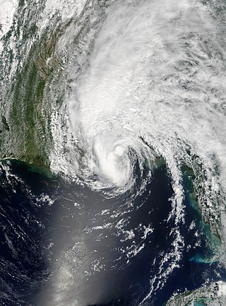
<span class="mw-page-title-main">Pensacola Bay</span> A bay in the northwestern part of Florida, United States, known as the Florida Panhandle

Pensacola Bay is a bay located in the northwestern part of Florida, United States, known as the Florida Panhandle.

Santa Rosa Sound is a sound connecting Pensacola Bay and Choctawhatchee Bay in Florida. The northern shore consists of the Fairpoint Peninsula and portions of the mainland in Santa Rosa County and Okaloosa County. It is bounded to the south by Santa Rosa Island, separating it from the Gulf of Mexico.

<span class="mw-page-title-main">Pensacola metropolitan area</span> Metropolitan statistical area in Florida, United States

The Pensacola metropolitan area is the metropolitan area centered on Pensacola, Florida. It is also known as the Pensacola-Ferry Pass-Brent Metropolitan Statistical Area, a metropolitan statistical area (MSA) used for statistical purposes by the United States Census Bureau and other agencies. The Pensacola Standard Metropolitan Statistical Area was first defined in 1958, with Pensacola as the principal city, and included Escambia and Santa Rosa counties. The SMA was renamed Pensacola-Ferry Pass-Brent MSA in 2003, with the unincorporated census-designated places Ferry Pass and Brent added as principal cities. The population of the MSA in the 2020 census was 511,502.

The history of Pensacola, Florida, begins long before the Spanish claimed founding of the modern city in 1698. The area around present-day Pensacola was inhabited by Native American peoples thousands of years before the historical era.

<span class="mw-page-title-main">Perdido Pass</span>

Perdido Pass, separating Alabama Point from Florida Point, is the mouth of the Perdido River. Perdido Pass forms a water passage that connects Perdido Bay with the Gulf of Mexico to the south, in the U.S. state of Alabama, 2 miles (3 km) west of the Alabama/Florida state line. A bridge spans Perdido Pass, connecting Alabama Point with Florida Point in Alabama. At the entrance into the Gulf, the 2 rock barriers, extending from the white beaches, are the west jetty & east jetty. The surrounding area is heavily developed, with high-rise condominiums. However, there are nearby beach-front parks, with Gulf State Park on the eastern side of Perdido Pass.

<span class="mw-page-title-main">Perdido Bay</span>

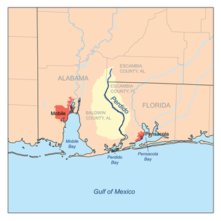
Perdido Bay is a bay at the mouth of and draining the Perdido River, a designated Outstanding Florida Waters river, in Baldwin County, Alabama and Escambia County, Florida, United States. It is essentially a coastal lagoon enclosed by barrier islands, with an inlet, Perdido Pass.

The following is an alphabetical list of articles related to the U.S. state of Florida.

Perdido Key is a 24 kilometres (15 mi) long barrier island on the north coast of the Gulf of Mexico. The island extends from Pensacola Pass on the east to Perdido Pass on the west. Most of the island is in Florida, with the western end of the island in Alabama. Santa Rosa Island is to the east of the island, and Alabama Point is to the west. Perdido Key was attached to the mainland until the 1940s when a canal separated it from the mainland. The eastern part of the island forms part of the Gulf Islands National Seashore, which includes the Perdido Key Historic District, the site of three shore batteries that once defended Pensacola Bay. The rest of the island, with the exception of the Perdido Key State Park, has been developed as a resort and residential community. As a barrier island, Perdidio Key is subject to changes due to wave action and longshore currents, particularly from hurricanes. The endangered Perdido Key beach mouse is endemic to the island.

References

  1. Work, Paul; Charles, Linda; Dean, Robert G. (June 1991). Perdido Key historical summary and interpretation of monitoring programs (Report). Coastal and Oceanographic Engineering Department, University of Florida. p. 18. Retrieved 2023-08-19 via University of Florida Digital Collections.
  2. "The Santa Rosa Island Shipwreck". 2012-12-09. Archived from the original on 2012-12-09. Retrieved 2020-10-20.
  3. Dysart, Jane E. (1999). "Indians in Colonial Pensacola". In Bense, Judith Anne (ed.). Archaeology of colonial Pensacola. University Press of Florida. p. 61. ISBN   0-8130-1661-4.
  4. Swanton, John Reed. (1952) The Indian Tribes of North America. Found at Google Books
    136
  5. Gougeon, Ramie A. (2020). "New Frontier, Old Frontier". In Boudreaux, Edmond A. III; Meyers, Maureen; Johnson, Jay K. (eds.). Contact, Colonialism, and Native Communities in the Southeastern United States. University of Florida Press. p. 114. ISBN   978-1-6834-0117-9.
  6. "Pensacola Bay", Wikipedia, 2020-09-17, retrieved 2020-10-20
  7. Bearss, Edwin C. (March 1982). "Historic structure report and resource study: Pensacola harbor defense project, 1890-1947, Florida unit, Gulf Islands National Seashore, Escambia & Santa Rosa counties". State University Libraries of Florida. pp. 123–139, 141–152, 293–295. Retrieved 2023-08-22.
  8. "National Register of Historic Places Inventory - Nomination Form - Perdido Key Historic District" (PDF). National Park Service History. December 11, 1979. Retrieved August 20, 2023.
  9. Work, Paul; Charles, Linda; Dean, Robert G. (June 1991). Perdido Key historical summary and interpretation of monitoring programs (Report). Coastal and Oceanographic Engineering Department, University of Florida. pp. 17, 21–22, 27. Retrieved 2023-08-19 via University of Florida Digital Collections.
  10. "National Register of Historic Places Inventory - Nomination Form - Perdido Key Historic District" (PDF). National Park Service History. December 11, 1979. Retrieved August 20, 2023.
  11. Schupp, Courtney A. (August 2019). Gulf Islands National Seashore Geologic Resources Inventory Report (PDF). National Park Service (Report). pp. 2, 18–20, 30. Retrieved August 19, 2023.
  12. "Unified Command for the BP Oil Spill | Pensacola Pass to Close", DH-27.
  13. "The City of Gulf Breeze Deep Water Horizon Oil Spill Response Plan" (PDF). Archived from the original (PDF) on 2014-10-06. Retrieved 2012-09-24.
  14. 1 2 3 Robinson, Kevin. "Pensacola ranks No. 12 in U.S. for toxic releases per square mile". Pensacola News Journal. Retrieved 2020-10-20.
  15. Hinchliffe, Alli. "FSU research finds Deepwater Horizon Oil in Gulf Coast beaches may take over 30 years to biodegrade". FSView. Retrieved 2020-10-20.
  16. "About Us | Florida Department of Health in Escambia". escambia.floridahealth.gov. Retrieved 2020-10-20.
  17. "RESTORE Act". myescambia.
  18. 1 2 "Health Consultation" (PDF). August 1, 2007.

30°19′41″N87°18′29″W / 30.328°N 87.308°W / 30.328; -87.308