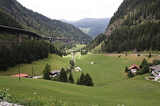
Brenner Pass is a mountain pass through the Alps which forms the border between Italy and Austria. It is one of the principal passes of the Eastern Alpine range and has the lowest altitude among Alpine passes of the area.

South Tyrol is an autonomous province in northern Italy. It is one of the two autonomous provinces that make up the autonomous region of Trentino-Alto Adige/Südtirol. Its official trilingual denomination is Autonome Provinz Bozen – Südtirol in German, Provincia autonoma di Bolzano – Alto Adige in Italian and Provinzia autonoma de Bulsan – Südtirol in Ladin, reflecting the three main language groups to which its population belongs. The province is the northernmost of Italy, the second largest, with an area of 7,400 square kilometres (2,857 sq mi) and has a total population of 530,009 inhabitants as of 2018. Its capital and largest city is Bolzano.

Bolzano is the capital city of the province of South Tyrol in northern Italy. With a population of 107,436, Bolzano is also by far the largest city in South Tyrol and the third largest in Tyrol. The metropolis has about 250,000 inhabitants and is one of the urban centers within the Alps.
Penne is a type of pasta.

Glurns is a comune (municipality) in South Tyrol in northern Italy, located about 80 kilometres (50 mi) northwest of Bolzano.

Prad am Stilfser Joch, often abbreviated to Prad or Prato, is a comune (municipality) in South Tyrol in northern Italy, located about 60 kilometres (37 mi) west of the city of Bolzano, on the border with Switzerland, and near the Stelvio Pass.

Vintl, is a comune (municipality) in South Tyrol in northern Italy, located about 45 kilometres (28 mi) northeast of Bolzano.
The E5 European long distance path or E5 path is one of the European long-distance paths from the French Atlantic coast in Brittany through Switzerland, Austria and Germany over the Alps to Verona in Italy. It is waymarked over the whole 3200 km distance. The heaviest used section is the last part, which crosses Europe’s highest mountains from Lake Constance to Italy. Even this part does not require climbing experience.

The Karerpass (1745 m) is a high mountain pass in the province of South Tyrol in Italy. It connects Bolzano through the Eggental and the Welschnofen Valley with the Fassa Valley. Just below the pass on the Welschnofen Valley side is the Karersee lake.
The Mendel Pass is a 1,362 metre-high mountain pass between the provinces of Trentino and South Tyrol in Italy.

The Penser Weißhorn is a mountain of the Sarntal Alps in South Tyrol, Italy. Located near the Penser Joch, its summit appears almost inaccessible due to its seemingly vertical pyramidal shape, although it is a popular location for hikers, and can be climbed by the sure footed in around two hours as a mini via ferrata has been established on its south face. The view from the summit takes in the whole of the Sarntal Alps.
The Sarntal Alps are a mountain range of the Eastern Rhaetian Alps, in South Tyrol (Italy), which surrounds the Sarntal (valley). It is limited by the Etschtal, Eisacktal, Passeiertal and the Jaufen Pass.

The Pfitscherjoch is a mountain pass in the Zillertal Alps on the border between Tyrol, Austria, and South Tyrol, Italy.

The Brenner Railway is a major line connecting the Austrian and Italian railways from Innsbruck to Verona, climbing up the Wipptal, passing over the Brenner Pass, descending down the Eisacktal to Bolzano/Bozen, then further down the Adige Valley to Roverto/Rofreit, and along the section of the Adige Valley, called in Italian the “Vallagarina”, to Verona. This railway line is part of the Line 1 of Trans-European Transport Networks (TEN-T). It is considered a "fundamental" line by the state railways Ferrovie dello Stato (FS).

The Eastern Rhaetian Alps are a mountain range in the central part of the Alps.

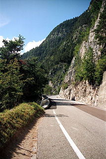
The Stelvio Pass is a mountain pass in northern Italy bordering Switzerland at an elevation of 2,757 m (9,045 ft) above sea level. It is the highest paved mountain pass in the Eastern Alps, and the second highest in the Alps, 13 m (43 ft) below France's Col de l'Iseran.

Tyrol is a historical region in the Alps; in northern Italy and western Austria. The area was to Habsburg times the former County of Tyrol. The Treaty of Saint-Germain-en-Laye in 1919 divided the area into two parts:

The Tuxer Joch is a mountain pass in the Zillertal Alps at a height of 2,338 m (AA) that links the lower Zillertal valley with the Brenner route just north of the Brenner Pass. To the northeast just below the summit lies the Tuxer Joch-Haus.

Zinseler is a mountain in the Sarntal Alps in South Tyrol in Italy. It has an elevation of 2,422 m and is located near Penser Joch saddle close to the city of Sterzing.

The Joch Pass is a mountain pass of the Uri Alps, located between the Bernese Oberland and Central Switzerland, at the foot of the Titlis. The pass crosses the col between the peaks of Graustock and Jochstock, at an elevation of 2,207 m (7,241 ft) and at the border between the cantons of Bern and Nidwalden.

