Pensthorpe Natural Park

Last updated

Pensthorpe Natural Park Pensthorpe Nature Reserve -near Fakenham -Norfolk-30May2009.jpg
Pensthorpe Natural Park
A view across a lake Pensthorpe Nature Reserve -near Fakenham -Norfolk-26oct2005.JPG
A view across a lake

Pensthorpe Natural Park is located in Pensthorpe, Norfolk, England and is approximately one mile from Fakenham and close to the A1067 road. The park covers 700 acres (280 ha). The River Wensum, which runs through the site, is a designated Special Area of Conservation (SAC). [1]

Kettlestone farm village in the United Kingdom

Kettlestone is a village and civil parish in the English county of Norfolk. It covers an area of 7.55 km2 (2.92 sq mi) and had a population of 177 in 85 households at the 2001 census, increasing to 197 at the 2011 Census. For the purposes of local government, it falls within the district of North Norfolk.

Norfolk County of England

Norfolk is a county in East Anglia in England. It borders Lincolnshire to the northwest, Cambridgeshire to the west and southwest, and Suffolk to the south. Its northern and eastern boundaries are the North Sea and, to the north-west, The Wash. The county town is Norwich. With an area of 2,074 square miles (5,370 km2) and a population of 859,400, Norfolk is a largely rural county with a population density of 401 per square mile. Of the county's population, 40% live in four major built up areas: Norwich (213,000), Great Yarmouth (63,000), King's Lynn (46,000) and Thetford (25,000).

England Country in north-west Europe, part of the United Kingdom

England is a country that is part of the United Kingdom. It shares land borders with Wales to the west and Scotland to the north-northwest. The Irish Sea lies west of England and the Celtic Sea lies to the southwest. England is separated from continental Europe by the North Sea to the east and the English Channel to the south. The country covers five-eighths of the island of Great Britain, which lies in the North Atlantic, and includes over 100 smaller islands, such as the Isles of Scilly and the Isle of Wight.

Contents

Pensthorpe Conservation Trust (PCT) was formed in January 2003. It is a charitable trust that works closely with Pensthorpe Natural Park to showcase the importance of species and habitat conservation. The PCT works with partner organisations in national conservation programmes to conserve wetland and farmland bird species. These partnerships include Operation Turtle Dove, The Great Crane Project and re-introduction projects for red squirrels and corncrakes.

Red squirrel species of tree squirrel common throughout Eurasia

The red squirrel or Eurasian red squirrel is a species of tree squirrel in the genus Sciurus common throughout Eurasia. The red squirrel is an arboreal, omnivorous rodent.

History

The site was created as a nature reserve by Bill Makins in the 1980s, before being bought by Bill and Deb Jordan in 2003, of Jordans cereals. During excavations to create the lakes and wader scrapes, one million tons of aggregates were excavated. The work uncovered finds including a hand axe believed to date from 8000 BC. Tusks and the tooth from a woolly mammoth were also found. [2]

Hand axe Stone tool

A hand axe is a prehistoric stone tool with two faces that is the longest-used tool in human history. It is usually made from flint or chert. It is characteristic of the lower Acheulean and middle Palaeolithic (Mousterian) periods. Its technical name (biface) comes from the fact that the archetypical model is generally bifacial Lithic flake and almond-shaped (amygdaloidal). Hand axes tend to be symmetrical along their longitudinal axis and formed by pressure or percussion. The most common hand axes have a pointed end and rounded base, which gives them their characteristic shape, and both faces have been knapped to remove the natural cortex, at least partially. Hand axes are a type of the somewhat wider biface group of two-faced tools or weapons.

Woolly mammoth An extinct species of mammoth from the Pleistocene epoch

The woolly mammoth is an extinct species of mammoth that lived during the Pleistocene until its extinction in the early Holocene epoch. It was one of the last in a line of mammoth species, beginning with Mammuthus subplanifrons in the early Pliocene. The woolly mammoth diverged from the steppe mammoth about 400,000 years ago in East Asia. Its closest extant relative is the Asian elephant. The appearance and behaviour of this species are among the best studied of any prehistoric animal because of the discovery of frozen carcasses in Siberia and Alaska, as well as skeletons, teeth, stomach contents, dung, and depiction from life in prehistoric cave paintings. Mammoth remains had long been known in Asia before they became known to Europeans in the 17th century. The origin of these remains was long a matter of debate, and often explained as being remains of legendary creatures. The mammoth was identified as an extinct species of elephant by Georges Cuvier in 1796.

Media

The reserve was the location of the BBC programme Springwatch from May 2008 to 2010. [3] [4]

The British Broadcasting Corporation (BBC) is a British public service broadcaster. Its headquarters are at Broadcasting House in Westminster, London, and it is the world's oldest national broadcasting organisation and the largest broadcaster in the world by number of employees. It employs over 20,950 staff in total, 16,672 of whom are in public sector broadcasting. The total number of staff is 35,402 when part-time, flexible, and fixed-contract staff are included.

<i>Springwatch</i> group of annual BBC television series which chart the fortunes of British wildlife during the changing of the seasons in the United Kingdom

Springwatch, Autumnwatch and Winterwatch are annual BBC television series which chart the fortunes of British wildlife during the changing of the seasons in the United Kingdom. The programmes are broadcast live from locations around the country in a primetime evening slot on BBC Two. They require a crew of 100 and over 50 cameras, making them the BBC's largest British outside broadcast events. Many of the cameras are hidden and operated remotely to record natural behaviour, for example, of birds in their nests and badgers outside their sett.

First broadcast in December 2013, the first episode of the BBC television series Great British Garden Revival was based in the reserve. [5]

<i>Great British Garden Revival</i> British documentary television series

Great British Garden Revival is a British documentary television series that was first broadcast on BBC Two on 9 December 2013. The series was presented by Monty Don, Carol Klein, Joe Swift, Rachel De Thame, James Wong, Tom Hart Dyke, Chris Beardshaw, Alys Fowler, Charlie Dimmock, Diarmuid Gavin, Christine Walkden, Toby Buckland, Sarah Raven and Matt James. Each episode shows two presenters focusing on an endangered part of gardens.

Related Research Articles

Ranworth Broad

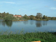
Ranworth Broad is a 136-hectare (340-acre) nature reserve on the Norfolk Broads north-east of Norwich in Norfolk. It is managed by the Norfolk Wildlife Trust. it is part of Bure Broads and Marshes Site of Special Scientific Interest and Bure Marshes Nature Conservation Review site, Grade I. and National Nature Reverse It is also part of the Broadland Ramsar site and Special Protection Area, and The Broads Special Area of Conservation.

Hickling Broad lake in the United Kingdom

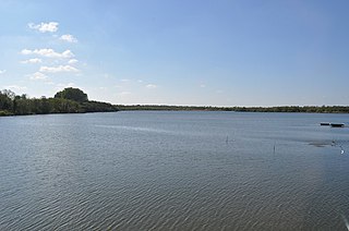
Hickling Broad is a 600-hectare (1,500-acre) nature reserve 4 km south-east of Stalham, north-east of Norwich in Norfolk. It is managed by the Norfolk Wildlife Trust. It is a National Nature Reserve and part of the Upper Thurne Broads and Marshes Site of Special Scientific Interest and Hickling Broad and Horsey Mere Nature Conservation Review site, Grade I. It is in the Norfolk Coast Area of Outstanding Natural Beauty, and part of the Broadland Ramsar site and Special Protection Area, and The Broads Special Area of Conservation.

This page gives an overview of the complex structure of environmental and cultural conservation in the United Kingdom.

Scottish Natural Heritage is the Scottish public body responsible for the country's natural heritage, especially its natural, genetic and scenic diversity. It advises the Scottish Government and acts as a government agent in the delivery of conservation designations, i.e. national nature reserves, local nature reserves, long distance routes, national parks, Sites of Special Scientific Interest (SSSIs), Special Areas of Conservation, Special Protection Areas and the national scenic area.

Ouse Washes nature reserve in the United Kingdom

Ouse Washes is a linear 2,513.6 hectare biological Site of Special Scientific Interest stretching from near St Ives in Cambridgeshire to Downham Market in Norfolk. It is also a Ramsar internationally important wetland site, a Special Protection Area under the European Union Birds Directive, a Special Area of Conservation, and a Nature Conservation Review site, Grade I. An area of 186 hectares between March and Ely is managed by the Wildlife Trust for Bedfordshire, Cambridgeshire and Northamptonshire, and another area near Chatteris is managed by the Royal Society for the Protection of Birds. The Wildfowl & Wetlands Trust manages another area near Welney.

Brett Westwood is a radio presenter and author, specialising in natural history. He regularly presents episodes of BBC Radio 4's series The Living World and Nature, as well as his own short series, several of which are available from the BBC website. He is a co-presenter with Philippa Forrester of World on the Move, a BBC Radio 4 series that started in 2008 on migration in the animal kingdom. He is active in the West Midland Bird Club, Worcestershire Wildlife Trust, and for the Worcestershire Biological Records Centre, which all cover the area around his home town of Stourbridge.

Chris Packham British naturalist

Christopher Gary Packham CBE is an English naturalist, nature photographer, television presenter and author, best known for his television work including the CBBC children's nature series The Really Wild Show from 1986 to 1995. He has also presented the BBC nature series Springwatch, including Autumnwatch and Winterwatch, since 2009.

Ynys-hir RSPB reserve RSPB nature reserve, situated beside the Dyfi estuary in Ceredigion, mid Wales.

Ynys-hir RSPB reserve is a nature reserve of the RSPB situated beside the Dyfi estuary in Ceredigion, mid Wales between Aberystwyth and Machynlleth. The reserve covers 550 hectares and includes a variety of habitats extending inland from mudflats and salt marsh through farmland and pools to oak woodland and hillside scrub. Facilities include a small visitor centre and seven hides.

Great Eastern Pingo Trail

Great Eastern Pingo Trail is a 9.2 kilometres long footpath along a disused railway line north of Thetford in Norfolk. It is a 4.2-hectare (10-acre) Local Nature Reserve, and it crosses three Sites of Special Scientific Interest, Thompson Water, Carr and Common, Breckland Forest and Cranberry Rough, Hockham. It also crosses Thompson Common, which is a nature reserve managed by the Norfolk Wildlife Trust and is a Nature Conservation Review site, Grade I. It further crosses Norfolk Valley Fens Special Area of Conservation and Breckland Special Protection Area.

Thompson Water, Carr and Common

Thompson Water, Carr and Common is a 154.7-hectare (382-acre) biological Site of Special Scientific Interest north of Thetford in Norfolk. Most of it is managed by the Norfolk Wildlife Trust as Thompson Common. It is a Nature Conservation Review site, Grade I, and part of the Norfolk Valley Fens Special Area of Conservation. It is crossed by the Great Eastern Pingo Trail Local Nature Reserve.

Roydon Common

Roydon Common is a 194.9-hectare (482-acre) biological Site of Special Scientific Interest east of King's Lynn in Norfolk. It is also a Grade I Nature Conservation Review site, a National Nature Reserve and a Ramsar site. It is part of the Roydon Common and Dersingham Bog Special Area of Conservation and Roydon Common and Grimston Warren nature reserve, which is managed by the Norfolk Wildlife Trust,

Foxley Wood

Foxley Wood is a nature reserve in Foxley, Norfolk, England, the largest ancient woodland and coppice in Norfolk. The Norfolk Wildlife Trust, which manages this reserve, bought it in 1998. It is 123 hectares in size. It is a Site of Special Scientific Interest, a Nature Conservation Review site, Grade 2, and a National Nature Reserve.

Cley Marshes nature reserve on the North Sea coast of England

Cley Marshes is a 176-hectare (430-acre) nature reserve on the North Sea coast of England just outside the village of Cley next the Sea, Norfolk. A reserve since 1926, it is the oldest of the reserves belonging to the Norfolk Wildlife Trust (NWT), which is itself the oldest county Wildlife Trust in the United Kingdom. Cley Marshes protects an area of reed beds, freshwater marsh, pools and wet meadows and is part of the North Norfolk Coast Site of Special Scientific Interest (SSSI), Special Area of Conservation (SAC), Special Protection Area (SPA), and Ramsar Site due to the large numbers of birds it attracts.

Protected areas of Scotland

Many parts of Scotland are protected in accordance with a number of national and international designations because of their environmental, historical or cultural value. Protected areas can be divided according to the type of resource which each seeks to protect. Scottish Natural Heritage has various roles in the delivery of many environmental designations in Scotland, i.e. those aimed at protecting flora and fauna, scenic qualities and geological features. Historic Environment Scotland is responsible for designations that protect sites of historic and cultural importance. Some international designations, such as World Heritage Sites, can cover both categories of site.

Ringstead Downs

Ringstead Downs is a 6.9-hectare (17-acre) biological Site of Special Scientific Interest east of Hunstanton in Norfolk. It is in the Norfolk Coast Area of Outstanding Natural Beauty, and it is the western part of the 11-hectare (27-acre) Ringstead Downs nature reserve, which is managed by the Norfolk Wildlife Trust.

Bure Broads and Marshes

Bure Broads and Marshes is a 741.1-hectare (1,831-acre) biological Site of Special Scientific Interest north-east of Norwich in Norfolk. Most of it is a Nature Conservation Review site, Grade I and National Nature Reserve. Two areas are nature reserves managed by the Norfolk Wildlife Trust, Cockshoot Broad and Ranworth Broad. It is part of the Broadland Ramsar site and Special Protection Area and The Broads Special Area of Conservation,

Felbrigg Woods

Felbrigg Woods is a 164.6-hectare (407-acre) biological Site of Special Scientific Interest south-west of Cromer in Norfolk. It is the main part of the grounds of Felbrigg Hall, a National Trust property which is listed on the Register of Historic Parks and Gardens of Special Historic Interest in England. It is a Nature Conservation Review site, Grade 2, and it is in the Norfolk Coast Area of Outstanding Natural Beauty.

Upper Thurne Broads and Marshes

Upper Thurne Broads and Marshes is a 1,185.9-hectare (2,930-acre) biological Site of Special Scientific Interest north of Great Yarmouth in Norfolk. Part of it is a Nature Conservation Review site, Grade I, and it is in the Norfolk Coast Area of Outstanding Natural Beauty. It is part of the Broadland Ramsar site and Special Protection Area, and The Broads Special Area of Conservation. Two areas, Hickling Broad and Martham Broad, are National Nature Reserves managed by the Norfolk Wildlife Trust.

References

  1. "SAC". jncc. Retrieved 1 July 2012.
  2. BBC Norfolk video tour Retrieved 24 October 2008
  3. BBC news item Retrieved 10 June 2010
  4. Springwatch 2009 Retrieved 9 May 2009
  5. Great British Garden Revival Retrieved 28 September 2014

Coordinates: 52°49′19″N0°53′17″E / 52.822°N 0.8881°E / 52.822; 0.8881

Geographic coordinate system Coordinate system

A geographic coordinate system is a coordinate system that enables every location on Earth to be specified by a set of numbers, letters or symbols. The coordinates are often chosen such that one of the numbers represents a vertical position and two or three of the numbers represent a horizontal position; alternatively, a geographic position may be expressed in a combined three-dimensional Cartesian vector. A common choice of coordinates is latitude, longitude and elevation. To specify a location on a plane requires a map projection.