In aviation, visual flight rules (VFR) are a set of regulations under which a pilot operates an aircraft in weather conditions generally clear enough to allow the pilot to see where the aircraft is going. Specifically, the weather must be better than basic VFR weather minima, i.e., in visual meteorological conditions (VMC), as specified in the rules of the relevant aviation authority. The pilot must be able to operate the aircraft with visual reference to the ground, and by visually avoiding obstructions and other aircraft.

The Maunder Minimum, also known as the "prolonged sunspot minimum", was a period around 1645 to 1715 during which sunspots became exceedingly rare. During the 28-year period 1672–1699 within the minimum, observations revealed fewer than 50 sunspots. This contrasts with the typical 40,000–50,000 sunspots seen in modern times over a similar timespan.

Missouri generally has a variety of seasonal humid subtropical climate, with cool winters and long, hot summers. In the southern part of the state, particularly in the Bootheel, the climate borders on a more mild-type humid subtropical climate, and in the northern third, the state transitions into a humid continental climate. Because of its location in the interior United States, Missouri often experiences extremes in temperatures. Lacking either large mountains or oceans nearby to moderate its temperature, its climate is alternately influenced by air from the cold Arctic and the hot and humid Gulf of Mexico.

In mathematical analysis, the maximum and minimum of a function are, respectively, the largest and smallest value taken by the function. Known generically as extremum, they may be defined either within a given range or on the entire domain of a function. Pierre de Fermat was one of the first mathematicians to propose a general technique, adequality, for finding the maxima and minima of functions.

A gale is a strong wind; the word is typically used as a descriptor in nautical contexts. The U.S. National Weather Service defines a gale as sustained surface wind moving at a speed between 34 and 47 knots. Forecasters typically issue gale warnings when winds of this strength are expected. In the United States, a gale warning is specifically a maritime warning; the land-based equivalent in National Weather Service warning products is a wind advisory.

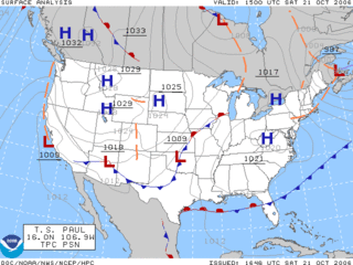
A weather map, also known as synoptic weather chart, displays various meteorological features across a particular area at a particular point in time and has various symbols which all have specific meanings. Such maps have been in use since the mid-19th century and are used for research and weather forecasting purposes. Maps using isotherms show temperature gradients, which can help locate weather fronts. Isotach maps, analyzing lines of equal wind speed, on a constant pressure surface of 300 or 250 hPa show where the jet stream is located. Use of constant pressure charts at the 700 and 500 hPa level can indicate tropical cyclone motion. Two-dimensional streamlines based on wind speeds at various levels show areas of convergence and divergence in the wind field, which are helpful in determining the location of features within the wind pattern. A popular type of surface weather map is the surface weather analysis, which plots isobars to depict areas of high pressure and low pressure. Cloud codes are translated into symbols and plotted on these maps along with other meteorological data that are included in synoptic reports sent by professionally trained observers.

Solar minimum is the regular period of least solar activity in the Sun's 11-year solar cycle. During solar minimum, sunspot and solar flare activity diminishes, and often does not occur for days at a time. On average, the solar cycle takes about 11 years to go from one solar minimum to the next, with duration observed varying from 9 to 14 years. The date of the minimum is described by a smoothed average over 12 months of sunspot activity, so identifying the date of the solar minimum usually can only happen 6 months after the minimum takes place.

The climate of Virginia, a state on the east coast of the United States, is mild compared to more northern areas of the United States such as New England and the Midwest. Most of Virginia east of the Blue Ridge mountains, the southern part of the Shenandoah Valley, and the Roanoke Valley, has a humid subtropical climate. In the mountainous areas west of the Blue Ridge, the climate is warm-summer humid continental or oceanic climate. Severe weather, in the form of tornadoes, tropical cyclones, and winter storms, impacts the state on a regular basis. Central Virginia received significant snowfall of 20 inches in December 2009.

In aviation, instrument meteorological conditions (IMC) are weather conditions that require pilots to fly primarily by reference to flight instruments, and therefore under instrument flight rules (IFR), as opposed to flying by outside visual references under visual flight rules (VFR). Typically, this means flying in cloud or poor weather, where little or nothing can be seen or recognised when looking out of the window. Simulated IMC can be achieved for training purposes by wearing view-limiting devices, which restrict outside vision and force the trainee to rely on instrument indications only.

The geography of the U.S. State of Colorado is diverse, encompassing both rugged mountainous terrain, vast plains, desert lands, desert canyons, and mesas. Colorado is a landlocked U.S. state. In 1861, the United States Congress defined the boundaries of the new Territory of Colorado exclusively by lines of latitude and longitude, stretching from 37°N to 41°N latitude, and from 102°02'48"W to 109°02'48"W longitude. Starting in 1868, official surveys demarcated the boundaries, deviating from the parallels and meridians in several places. Later surveys attempted to correct some of these mistakes but in 1925 the U.S. Supreme Court affirmed that the earlier demarcation was the official boundary. The borders of Colorado are now officially defined by 697 boundary markers connected by straight boundary lines. Colorado, Wyoming, and Utah are the only states that have their borders defined solely by straight boundary lines with no natural features. The southwest corner of Colorado is the Four Corners Monument at 36°59'56"N, 109°2'43"W. This is the only place in the United States where four states meet: Colorado, New Mexico, Arizona, and Utah.

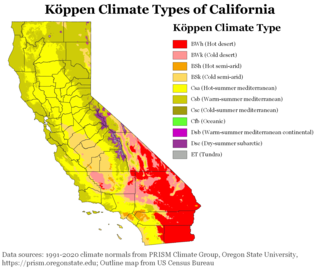
The climate of California varies widely from hot desert to alpine tundra, depending on latitude, elevation, and proximity to the Pacific Coast. California's coastal regions, the Sierra Nevada foothills, and much of the Central Valley have a Mediterranean climate, with warmer, drier weather in summer and cooler, wetter weather in winter. The influence of the ocean generally moderates temperature extremes, creating warmer winters and substantially cooler summers in coastal areas.
Columbus, Ohio has a humid continental climate, characterized by humid, hot summers and cold winters, with no dry season. The Dfa climate has average temperatures above 22 °C during the warmest months, with at least four months averaging above 10 °C, and below 0 °C during the coldest. The climate is transitional with the Cfa humid subtropical climate to the south, characterized by humid, hot summers and cool winters.
The Climate of Grand Forks, North Dakota is a warm summer continental typical of cities located in the Great Plains, with four very distinct seasons and great variation in temperatures over very short periods of time. The city's climate is characterized by long, cold winters with moderate snowfall and warm summers which are typically humid.
The winter of 1894–1895 was severe for the British Isles with a Central England temperature (CET) of 1.17 °C or 34.1 °F. Many climatologists have come to view this winter as the end of the Little Ice Age and the culmination of a decade of harsh winters in Britain. Whereas the average CET for the 10 winters from 1885–1886 to 1894–1895 was 2.87 °C or 37.2 °F, no winter with a CET under 3.0 °C or 37.4 °F followed for 22 years and no month as cold as February or January 1895 until 1940. In contrast, between 1659 and 1894, no spell with every winter CET above 3.0 °C or 37.4 °F had lasted longer than 12 winters.[b]

The climate in Brazil varies considerably from mostly tropical north to temperate zones south of the Tropic of Capricorn.

North Dakota's climate is typical of a continental climate with cold winters and warm-hot summers. The state's location in the Upper Midwest allows it to experience some of the widest variety of weather in the United States, and each of the four seasons has its own distinct characteristics. The eastern half of the state has a humid continental climate with warm to hot, somewhat humid summers and cold, windy winters, while the western half has a semi-arid climate with less precipitation and less humidity but similar temperature profiles. The areas east of the Missouri River get slightly colder winters, while those west of the stream get higher summer daytime temperatures. In general, the diurnal temperature difference is prone to be more significant in the west due to higher elevation and less humidity.

The climate of Pennsylvania is diverse due to the multitude of geographic features found within the state. Straddling two major climate zones, the southeastern corner of Pennsylvania has the warmest climate. A portion of Greater Philadelphia lies at the southernmost tip of the humid continental climate zone, with the city proper being in the humid subtropical climate zone. Still, Philadelphia features colder, snowier winters than most locations with a humid subtropical climate. Moving west toward the mountainous interior of the state, the climate becomes markedly colder, the number of cloudy days increases, and winter snowfall amounts are greater.

The climate of New York (state) is generally humid continental, while the extreme southeastern portion of the state lies in the warmer humid subtropical climate zone. Winter temperatures average below freezing during January and February in much of the state of New York, but several degrees above freezing along the Atlantic coastline, including New York City.

The climate of New England varies greatly across its 500-mile (800 km) span from northern Maine to southern Connecticut.
Reduced Lateral Separation Minima, is an aeronautical flight term identifying the reduction from standard lateral separation minima between aircraft to a lower amount deemed safe, first introduced on the North Atlantic in December 2015 for the North Atlantic Tracks.


