Permanent Maghreb

Last updated
Permanent Maghreb
A river in Zaouia d'Ifrane.jpg
Cascade in Zaouia d'Ifrane, Morocco
Ecology
Borders Temporary Maghreb
Geography
Area950,180 km2 (366,870 sq mi)
Countries
Climate type Mediterranean

The Permanent Maghreb of World Wide Fund for Nature is a freshwater ecoregion of North Africa.

Contents

Geography

The Permanent Maghreb ecoregion covers an area of 950,180 square kilometers, and extends across the portions of Algeria, Mauritania, Morocco, Tunisia, and Western Sahara. It occupies the Mediterranean climate region of northern Africa, and is characterized by rivers and streams which flow on the surface year-round. The ecoregion is bounded on the north by the Atlantic Ocean and Mediterranean Sea, and to the south by the Temporary Maghreb freshwater ecoregion, which covers the northern portion of the Sahara and is characterized by temporary or seasonally-flowing rivers and streams. [1]

The WWF divides the ecoregion into two. Atlantic Northwest Africa lies in northwestern Africa, covering most of Morocco and Western Sahara and portions of Mauritania and Algeria. The ecoregion covers the western Atlas Mountains complex, including the Anti-Atlas to the west, the High Atlas, the Middle Atlas further east, and Rif Mountains along the Mediterranean coast. The rivers flow into the Atlantic, or inland into the Sahara. The main streams flowing into the Atlantic are the Sebou, Oum Er-Rbia, Tensift, and Sous. [2]

Mediterranean Northwest Africa lies further east, covering the northern portions of Tunisia and Algeria along with eastern Morocco. The streams originate in the eastern portion of the Atlas Mountains complex, including the Tell Atlas, the Saharan Atlas, and the Aures Mountains. Its principal rivers include the Moulouya, Chelif, and Medjerda, which empty into the Mediterranean Sea. [3]

Habitats

The major habitat types of the ecoregion are Mediterranean systems and temperate coastal rivers. [4] Most of the rivers originate in the Atlas mountains. Rainfall is generally higher in the winter months, and there is regular winter snowfall at higher elevations which creates spring snowmelt. The largest rivers empty into the sea, forming reedy wetlands at river mouths. The Atlantic rivers are generally more species-rich. The streams which flow towards the Sahara mostly empty into chotts, shallow saline lakes which vary seasonally in extent. The streams that flow southward into the Sahara sustain desert aquifers. [2]

Fauna

The freshwater fauna of the Permanent Maghreb shares affinities with of Europe’s Mediterranean freshwater ecoregions. It is home to Africa's only native salmonids and Cobitis maroccana , Africa's only representative of family Cobitidae. Atlantic Northwest Africa has greater affinities with Iberia, while Mediterranean Northwest Africa has some Asiatic species. [2]

Endemic fish species of Atlantic Northwest Africa include Salmo akairos, Salmo pallaryi (now extinct), Cobitis maroccana, and several species of Barbus ( B. labiosa, B. magniatlantis, B. ksibi, B. issenensis, B. massaensis, B. nasus, B. harterti, B. paytonii, B. reinii , and two more undescribed species). Near-endemic species include Varicorhinus maroccanus and Barbus pallaryi , which also range into the adjacent Temporary Maghreb. Other fish species include Tilapia zillii, Labeobarbus fritschii, Atherina boyeri , and Alosa alosa . [2]

Endemic fish species of the Mediterranean Northwest Africa ecoregion include Pseudophoxinus callensis, P. punicus, Barbus callensis, B. leptopogon, Tropidophoxinellus chaignoni , and Aphanius apodus . Other fish species include Aphanius fasciatus, Barbus fritschii, Salaria fluviatilis , and Salmo macrostigma . [3]

Related Research Articles

<span class="mw-page-title-main">Atlas Mountains</span> North African mountain range

The Atlas Mountains are a mountain range in the Maghreb in North Africa. It separates the Sahara Desert from the Mediterranean Sea and the Atlantic Ocean; the name "Atlantic" is derived from the mountain range. It stretches around 2,500 km (1,600 mi) through Morocco, Algeria and Tunisia. The range's highest peak is Toubkal, which is in central Morocco, with an elevation of 4,167 metres (13,671 ft). The Atlas mountains are primarily inhabited by Berber populations.

<span class="mw-page-title-main">Palearctic realm</span> Biogeographic realm covering most of Eurasia

The Palearctic or Palaearctic is the largest of the eight biogeographic realms of the Earth. It stretches across all of Eurasia north of the foothills of the Himalayas, and North Africa.

<span class="mw-page-title-main">Tigris–Euphrates river system</span> River system in the Middle East

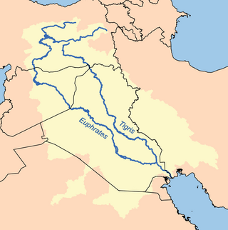
The Tigris–Euphrates river system is a large river system in Western Asia which discharges into the Persian Gulf. Its principal rivers are the Tigris and Euphrates along with smaller tributaries.

<span class="mw-page-title-main">Maghreb</span> Major region of North Africa; western half of Arab world

The Maghreb, also known as the Arab Maghreb and Northwest Africa, is the western part of the Arab world. The region comprises western and central North Africa, including Algeria, Libya, Mauritania, Morocco, and Tunisia. The Maghreb also includes the disputed territory of Western Sahara and the Spanish cities Ceuta and Melilla. As of 2018, the region had a population of over 100 million people.

<i>Salmo</i> Genus of fishes

Salmo is a genus of ray-finned fish from the family Salmonidae. The single Salmo species naturally found in the Atlantic North America is the Atlantic salmon, whereas the salmon and trout of the Pacific basin belong to another genus, Oncorhynchus. The natural distribution of Salmo also extends to North Africa and to West Asia around the Black Sea basin.

Barbus lepineyi is a doubtfully distinct ray-finned fish species in the family Cyprinidae.

Cobitis maroccana is a species of ray-finned fish in the family Cobitidae.

Mediterranean <i>Acacia–Argania</i> dry woodlands

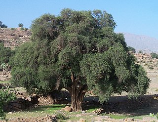
The Mediterranean Acacia–Argania dry woodlands and succulent thickets is a Mediterranean forests, woodlands, and scrub ecoregion in North Africa centered mainly on Morocco but also including northwestern Western Sahara and the eastern Canary Islands.

<span class="mw-page-title-main">Mediterranean woodlands and forests</span> Ecoregion in Northern Africa

The Mediterranean woodlands and forests is an ecoregion in the coastal plains, hills, and mountains bordering the Mediterranean Sea and Atlantic Ocean in North Africa. It has a Mediterranean climate, and is in the Mediterranean forests, woodlands, and scrub biome.

<span class="mw-page-title-main">Mediterranean dry woodlands and steppe</span> Mediterranean forests, woodlands, and scrub ecoregion of North Africa

The Mediterranean dry woodlands and steppe is a Mediterranean forests, woodlands, and scrub ecoregion of North Africa. It occupies interior plateaus and mountain ranges of the Maghreb region, lying generally between the coastal Mediterranean woodlands and forests to the north and the Sahara to the south.

<span class="mw-page-title-main">Southwestern Sri Lanka rivers and streams</span> Ecological region

Southwestern Sri Lanka rivers and streams is a freshwater ecoregion in Sri Lanka. The ecoregion is listed in Global 200, a list of ecoregions compiled by the World Wide Fund for Nature for conservation priorities. The extensive network of rivers and streams of Sri Lanka drains a total of 103 distinct natural river basins. Several waterfall habitats have been formed as a result of rivers and streams flowing through high and mid elevation areas. The ecoregion spreads over 15,500 km2 in the wet zone of the southwestern part of Sri Lanka. More than a quarter of the freshwater fishes that have been discovered in Southwestern Sri Lanka rivers and streams are endemic. Nine endemic genera of freshwater fishes of Western Ghats and Sri Lanka hotspot Malpulutta are found only in Sri Lanka. Studies suggest that the number of species still to be discovered is quite high. Until recently wetlands in Sri Lanka were used for drainage, construction sites and land fills.

Luciobarbus is a genus of ray-finned fishes in the family Cyprinidae. Its members are found in fresh and brackish waters of southern Europe, northern Africa, the wider Near East, the Aral and Caspian Seas, and rivers associated with these. Several species in the genus are threatened. Most species are fairly small to medium-sized cyprinids, but the genus also includes several members that can surpass 1 m (3.3 ft) in length and the largest, the mangar can reach 2.3 m (7.5 ft).

<span class="mw-page-title-main">Nimba Range</span> Southern extent of the Guinea highlands

The Nimba Range forms part of the southern extent of the Guinea Highlands. The highest peak is Mount Richard-Molard on the border of Côte d'Ivoire and Guinea, at 1,752 m (5,748 ft). "Mount Nimba" may refer either to Mount Richard-Molard or to the entire range. Other peaks include Grand Rochers at 1,694 m (5,558 ft), Mont Sempéré at 1,682 m (5,518 ft), Mont Piérré Richaud at 1,670 m (5,480 ft), Mont Tô at 1,675 m (5,495 ft), and Mont LeClerc 1,577 m (5,174 ft), all of them are located in Guinea. Mount Nimba Strict Nature Reserve of Guinea and Côte d'Ivoire covers significant portions of the Nimba Range.

References

  1. Thieme, Michelle L. (2005). Freshwater Ecoregions of Africa and Madagascar: A Conservation Assessment. Island Press, Washington DC.
  2. 1 2 3 4 "Atlantic Northwest Africa". Freshwater Ecoregions of the World. Accessed 13 May 2021. https://www.feow.org/ecoregions/details/501
  3. 1 2 "Mediterranean Northwest Africa". Freshwater Ecoregions of the World. Accessed 13 May 2021. https://www.feow.org/ecoregions/details/502
  4. Garcia, N. (2010). The status and distribution of freshwater biodiversity in northern Africa. Gland: IUCN. p. 2.