Perperek Knoll

Last updated
Location of Varna Peninsula on Livingston Island in the South Shetland Islands Varna-Peninsula-location-map.png
Location of Varna Peninsula on Livingston Island in the South Shetland Islands
Perperek Knoll from Ongal Peak Perperek-Livingston.jpg
Perperek Knoll from Ongal Peak
Topographic map of Livingston Island and Smith Island Livingston-Island-Map-2010-15.png
Topographic map of Livingston Island and Smith Island

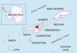
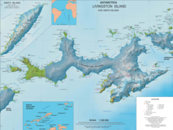
Perperek Knoll (Perperekska Mogila \per-pe-'rek-ska mo-'gi-la\) is a 360 m peak in Vidin Heights on Varna Peninsula, Livingston Island in the South Shetland Islands, Antarctica. It has partly ice-free southeast slopes. The peak is named after the settlement of Perperek in the Rhodope Mountains site of the ancient town of Perperikon. [1]

Contents

Location

The knoll is located at 62°32′57″S60°07′41″W / 62.54917°S 60.12806°W / -62.54917; -60.12806 which is 5.77 km north of Sliven Peak, 4.51 km northeast of Leslie Hill and 2.41 km southeast of Miziya Peak (Bulgarian topographic survey Tangra 2004/05, and mapping in 2005 and 2009).

Maps

Notes

References


This article includes information from the Antarctic Place-names Commission of Bulgaria which is used with permission.