
Forrestfield is a suburb of the City of Kalamunda in Western Australia. It lies 15 kilometres to the south-east of Perth at the base of the Darling Scarp and the southern border of Perth Airport.

Great Eastern Highway is a 590-kilometre-long (370 mi) road that links the Western Australian capital of Perth with the city of Kalgoorlie. A key route for road vehicles accessing the eastern Wheatbelt and the Goldfields, it is the western portion of the main road link between Perth and the eastern states of Australia. The highway forms the majority of National Highway 94, although the alignment through the Perth suburbs of Guildford and Midland, and the eastern section between Coolgardie and Kalgoorlie are not included. Various segments form parts of other road routes, including National Route 1, Alternative National Route 94, and State Route 51.
Midland Line is a suburban railway line on the Transperth Trains network in Perth, Western Australia. It runs through Perth's eastern suburbs and connects Midland with Perth and Fremantle.
The Fremantle railway line is a suburban railway line in Western Australia that connects the state capital of Perth with the port city of Fremantle.
Mitchell Freeway is a 36-kilometre-long (22 mi) freeway in the northern suburbs of Perth, Western Australia, linking central Perth with the satellite city of Joondalup. It is the northern section of State Route 2, which continues south as Kwinana Freeway and Forrest Highway. Along its length are interchanges with several major roads, including Graham Farmer Freeway and Reid Highway. The southern terminus of the Mitchell Freeway is at the Narrows Bridge, which crosses the Swan River, and the northern terminus is at Hester Avenue, Clarkson, a suburb within the City of Wanneroo.
Western Australian Government Railways (WAGR) was the operator of railway services in the state of Western Australia between October 1890 and June 2003. Owned by the State Government, it was renamed a number of times to reflect extra responsibility for tram and ferry operations that it assumed and later relinquished. Its freight operations were privatised in December 2000 with the remaining passenger operations transferred to the Public Transport Authority in July 2003.

South Fremantle is a suburb of Perth, Western Australia, located within the City of Fremantle.
The Claremont Showground near Perth, Western Australia is home to the annual Perth Royal Show. In 1902, 32 acres of land were reserved in the Perth suburb of Claremont for new showgrounds to replace the Guildford Showgrounds. The Royal Agricultural Show, of three days, was first held there in October and November 1905.

Tonkin Highway is a 51-kilometre-long (32 mi) north-south highway and partial freeway in Perth, Western Australia, linking Perth Airport and Kewdale with the city's north-eastern and south-eastern suburbs. As of October 2019, the northern terminus is at The Promenade in Ellenbrook, and the southern terminus is at Thomas Road in Oakford. It forms the entire length of State Route 4, and connects to several major roads, including Reid Highway, Great Eastern Highway, Leach Highway, Roe Highway, and Albany Highway.
High Wycombe is a suburb of Perth, Western Australia, within the City of Kalamunda. High Wycombe lies east of the Perth CBD at the base of the Darling Scarp. Formerly part of Maida Vale, the suburb was officially declared on 2 June 1978; its name, which was first used in 1958 by a subdivider, Western Agencies, and refers to the town in Buckinghamshire where one of the partners in the firm was born.

The Horseshoe Bridge in Perth, Western Australia, connects the Perth CBD to Northbridge, carrying William Street over the Fremantle railway line. It was constructed in 1904, with the horseshoe shape designed to fit the approach ramps into a constricted site. The bridge was closed from the end of 2009 to early 2010 to enable conversion to two-way traffic flow.

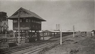
Swan View railway station, Perth was a railway station of significance on the Eastern Railway in Western Australia. In all Working Timetables (WTT) during the operation of this line, the station was the point of control for the Swan View Tunnel.

William Street is a suburban distributor and one of two major cross-streets in the CBD of Perth, Western Australia. Commencing in western Mount Lawley it also crosses the Perth to Fremantle railway at the Horseshoe Bridge. It is a one-way street from Brisbane Street to Newcastle Street, from which point until its terminus at The Esplanade it has been progressively converted to two-way since 2008. Its route takes it through the Northbridge cafe and nightclub district as well as Perth's central business district. A ramp which took William Street traffic from The Esplanade onto the southbound Kwinana Freeway was closed in 2004 during the construction of the Esplanade railway station.
Kalgoorlie railway station is the most eastern attended station in Western Australia, located at the eastern terminus of the Eastern Goldfields Railway. It serves the city of Kalgoorlie. Beyond Kalgoorlie the line continues east as the Trans-Australian Railway.

Bunbury Bridge was a single-track, timber railway bridge in East Perth in Western Australia. The bridge crossed the Swan River near Claise Brook and was built for passenger and freight traffic to Bunbury on the South Western Railway, and was also part of the Armadale railway line.
Perth City Link is an urban renewal and redevelopment project in Perth, Western Australia.

Barrack Street Bridge is the second crossing of the Eastern Railway line at its location at the eastern end of the Perth Railway Station yard in Perth, Western Australia. Despite its name, the bridge carries Beaufort Street, and was previously known as the Beaufort Street Bridge.
The Forrestfield–Airport Link is a railway line currently under construction on the Transperth network in Perth, Western Australia. The line is intended to service Perth Airport and the Perth foothills with a terminus in Forrestfield.
Forrestfield railway station is a future railway station currently under construction on the Transperth network. When completed, it will be the terminus of the Forrestfield-Airport Link, 8.5 kilometres (5.3 mi) from Bayswater station serving the suburbs of Forrestfield, High Wycombe, Maida Vale, and Kalamunda.

The Kwinana freight railway lines are a network of railways predominantly servicing the heavy industrial areas at Kwinana Beach south of Perth and to provide for the transport of freight servicing Fremantle Harbour, Kewdale Intermodal Facility and other freight destinations Perth. While some lines were constructed in the 1900s, most of the network was constructed in the 1950s and 1960s.