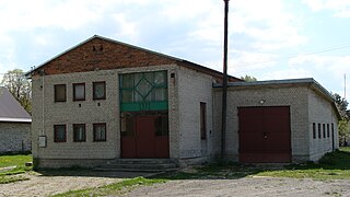
Gmina Radków is a rural gmina in Włoszczowa County, Świętokrzyskie Voivodeship, in south-central Poland. Its seat is the village of Radków, which lies approximately 16 kilometres (10 mi) south of Włoszczowa and 49 km (30 mi) south-west of the regional capital Kielce.

Danków Duży is a village in the administrative district of Gmina Włoszczowa, within Włoszczowa County, Świętokrzyskie Voivodeship, in south-central Poland. It lies approximately 5 kilometres (3 mi) north-west of Włoszczowa and 48 km (30 mi) west of the regional capital Kielce.
Danków Mały is a village in the administrative district of Gmina Włoszczowa, within Włoszczowa County, Świętokrzyskie Voivodeship, in south-central Poland. It lies approximately 3 kilometres (2 mi) north-west of Włoszczowa and 49 km (30 mi) west of the regional capital Kielce.
Pilczyca is a village in the administrative district of Gmina Kluczewsko, within Włoszczowa County, Świętokrzyskie Voivodeship, in south-central Poland. It lies approximately 2 kilometres (1 mi) north-west of Kluczewsko, 11 km (7 mi) north-west of Włoszczowa, and 51 km (32 mi) west of the regional capital Kielce.
Brygidów is a village in the administrative district of Gmina Krasocin, within Włoszczowa County, Świętokrzyskie Voivodeship, in south-central Poland. It lies approximately 5 kilometres (3 mi) north of Krasocin, 14 km (9 mi) north-east of Włoszczowa, and 36 km (22 mi) west of the regional capital Kielce.

Chebdzie is a village in the administrative district of Gmina Moskorzew, within Włoszczowa County, Świętokrzyskie Voivodeship, in south-central Poland. It lies approximately 4 kilometres (2 mi) south of Moskorzew, 25 km (16 mi) south of Włoszczowa, and 55 km (34 mi) south-west of the regional capital Kielce.

Chlewice is a village in the administrative district of Gmina Moskorzew, within Włoszczowa County, Świętokrzyskie Voivodeship, in south-central Poland. It lies approximately 5 kilometres (3 mi) east of Moskorzew, 23 km (14 mi) south of Włoszczowa, and 51 km (32 mi) south-west of the regional capital Kielce.

Chlewska Wola is a village in the administrative district of Gmina Moskorzew, within Włoszczowa County, Świętokrzyskie Voivodeship, in south-central Poland. It lies approximately 3 kilometres (2 mi) north-east of Moskorzew, 19 km (12 mi) south of Włoszczowa, and 51 km (32 mi) south-west of the regional capital Kielce.
Dąbrówka is a village in the administrative district of Gmina Moskorzew, within Włoszczowa County, Świętokrzyskie Voivodeship, in south-central Poland. It lies approximately 5 kilometres (3 mi) north-west of Moskorzew, 20 km (12 mi) south of Włoszczowa, and 57 km (35 mi) south-west of the regional capital Kielce.
Dalekie is a village in the administrative district of Gmina Moskorzew, within Włoszczowa County, Świętokrzyskie Voivodeship, in south-central Poland. It lies approximately 5 kilometres (3 mi) west of Moskorzew, 24 km (15 mi) south of Włoszczowa, and 58 km (36 mi) south-west of the regional capital Kielce.
Damiany is a village in the administrative district of Gmina Moskorzew, within Włoszczowa County, Świętokrzyskie Voivodeship, in south-central Poland. It lies approximately 3 kilometres (2 mi) south-east of Moskorzew, 23 km (14 mi) south of Włoszczowa, and 53 km (33 mi) south-west of the regional capital Kielce.
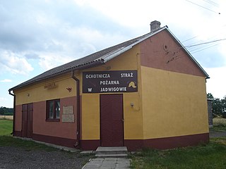
Jadwigów is a village in the administrative district of Gmina Moskorzew, within Włoszczowa County, Świętokrzyskie Voivodeship, in south-central Poland. It lies approximately 7 kilometres (4 mi) south-east of Moskorzew, 25 km (16 mi) south of Włoszczowa, and 51 km (32 mi) south-west of the regional capital Kielce.
Lubachowy is a village in the administrative district of Gmina Moskorzew, within Włoszczowa County, Świętokrzyskie Voivodeship, in south-central Poland. It lies approximately 4 kilometres (2 mi) south-east of Moskorzew, 25 km (16 mi) south of Włoszczowa, and 54 km (34 mi) south-west of the regional capital Kielce.
Mękarzów is a village in the administrative district of Gmina Moskorzew, within Włoszczowa County, Świętokrzyskie Voivodeship, in south-central Poland. It lies approximately 5 kilometres (3 mi) north-west of Moskorzew, 20 km (12 mi) south of Włoszczowa, and 57 km (35 mi) south-west of the regional capital Kielce.

Moskorzew is a village in Włoszczowa County, Świętokrzyskie Voivodeship, in south-central Poland. It is the seat of the gmina called Gmina Moskorzew. It lies approximately 23 kilometres (14 mi) south of Włoszczowa and 55 km (34 mi) south-west of the regional capital Kielce.
Przybyszów is a village in the administrative district of Gmina Moskorzew, within Włoszczowa County, Świętokrzyskie Voivodeship, in south-central Poland. It lies approximately 4 kilometres (2 mi) south-west of Moskorzew, 25 km (16 mi) south of Włoszczowa, and 57 km (35 mi) south-west of the regional capital Kielce.

Tarnawa Góra is a village in the administrative district of Gmina Moskorzew, within Włoszczowa County, Świętokrzyskie Voivodeship, in south-central Poland. It lies approximately 6 kilometres (4 mi) west of Moskorzew, 24 km (15 mi) south of Włoszczowa, and 59 km (37 mi) south-west of the regional capital Kielce.
Bichniów is a village in the administrative district of Gmina Secemin, within Włoszczowa County, Świętokrzyskie Voivodeship, in south-central Poland. It lies approximately 3 kilometres (2 mi) south-east of Secemin, 14 km (9 mi) south-west of Włoszczowa, and 55 km (34 mi) west of the regional capital Kielce.
Kluczyce is a village in the administrative district of Gmina Secemin, within Włoszczowa County, Świętokrzyskie Voivodeship, in south-central Poland. It lies approximately 5 kilometres (3 mi) south-west of Secemin, 18 km (11 mi) south-west of Włoszczowa, and 60 km (37 mi) west of the regional capital Kielce.


