Petit-Montrouge

Last updated
Alesia Square (Carrefour Alesia) and the church Saint-Pierre de Montrouge, at the centre of the quartier du Petit-Montrouge Carrefour Alesia 1.JPG
Alésia Square (Carrefour Alésia) and the church Saint-Pierre de Montrouge, at the centre of the quartier du Petit-Montrouge

The quartier du Petit-Montrouge is number 55 of the 80 quartiers administratifs (administrative districts) in Paris. It lies in the 14th Arrondissement, in the south of the capital. It owes its name to the adjacent commune of Montrouge, of which it formed a part before 1860. It is familiar as the quartier Alésia, from the name of a street that bisects it and from the principal Métro station that serves it, although the quartier Alésia does not exactly overlap the quartier du Petit-Montrouge.

Contents

Location

The quartier du Petit-Montrouge is delimited by Rue Daguerre and Boulevard Saint-Jacques to the north, by Rue de la Tombe-Issoire to the east, by Boulevard Romain Rolland to the south, and Avenue de la Porte de Châtillon and Rue des Plantes and Rue Gassendi to the west.

It is bordered to the north by the quartier du Montparnasse, to the east by the quartier du Parc de Montsouris, to the south by the commune of Montrouge, and to the west by the quartier de Plaisance.

History

The quartier du Petit-Montrouge was created at the same time as the 14th Arrondissement in 1860, when Paris annexed a part of the commune of Montrouge. Montrouge was originally divided into two distinct sectors, Grand-Montrouge (corresponding to the current commune of Montrouge) and Petit-Montrouge, the church housing development launched around 1840, the centre of which is now called Place Michel Audiard. Still at this site today is a building in the French Directory architectural style, which was the old city hall annex of Montrouge (44, rue Du Couédic, 48°49′48″N2°19′51″E / 48.83006°N 2.33088°E / 48.83006; 2.33088 ).

Geography

From a topographical point of view, Petit-Montrouge is situated on a plateau atop the hillsides of the left bank of the Bièvre. Overall it is flat. The centre of the quartier (as well as the centre of the arrondissement) is Place Hélène et Victor Basch, better known as Carrefour Alésia ( 48°49′40″N2°19′37″E / 48.827889°N 2.326816°E / 48.827889; 2.326816 ). That is the point of convergence of the old routes of Chartres and Orléans, from which the flow of traffic is redistributed to the whole of the left bank of the capital by Rue d'Alésia, Avenue du Maine, and Avenue du Général Leclerc (which constitutes the backbone of the quartier). A network of more or less perpendicular streets serves the entire quartier, testifying to a belated urbanization.

Urban planning

The Halle villa, residential cul-de-sac typical of the quartier Villa Halle 1.JPG
The Hallé villa, residential cul-de-sac typical of the quartier
A Faubourgian house predating Haussmann's renovation of Paris Rue Halle.JPG
A Faubourgian house predating Haussmann's renovation of Paris
The architectural "melting-pot", Rue Bezout Rue Bezout 2.JPG
The architectural "melting-pot", Rue Bezout

The belated urbanization of the quartier (after 1840), together with the availability of land, led to a great architectural diversity. The residential areas are composed of buildings of all styles. There is no great number of Haussmanian edifices, the quartier having largely been untouched by Second French Empire urban redevelopment. They are mostly found by the town hall and on Rue Alésia. Entirely Haussmanian streets, like Rue du Lunain, are rather rare. Façades in plaster are more common, testifying to the working class past of the quartier. Buildings of the 1930s are more present in the south, particularly in the ancient zone of fortifications. Finally the post-war architecture is also well represented, for better and for worse. One of the characteristics of the quartier is the importance of the individual home. Many plots were built only in façade, leaving the place for city houses or artists' workshops, often adorned with private gardens, invisible from the street. This type of construction is also found in the dead end streets (the "villas"), occasionally with real architectural treasures. Certain streets, like Rue Bezout, form an authentic architectural museum offering to the visitor a variety of styles, sizes, eras of construction, and volumes. Concentrated in this quartier are also numerous Faubourgian buildings, predating the 1860 annexation, of one or two storeys, rare in the Parisian landscape. Office buildings are almost absent from this residential and shopping quartier, with the notable exception of the extreme south of the quartier, bordering on the commune of Montrouge.

Social composition

Until the 1960s it was a working class quartier, composed primarily of workmen, employees, merchants and members of the middle class. These groups of people arrived in the neighborhood during the Renovation of Paris, led by Napoleon III and the architect and urban planner Georges-Eugène Haussmann. This displacement was a forced migration. The class that suffered most in the past from the medieval living conditions of old Paris was exiled to the suburbs by Haussmannization, since the slums were cleaned up and replaced by apartments for the bourgeoisie. The renovations of the city center entailed a rise in rents that would have forced poor families to move to the outlying districts. Another factor that led to the marginalization of this sector of society was the exponential increase in migration to the city, headed by people belonging to the sector of society already mentioned, and from the agrarian sector, in search of work and a life in civilization. The population moved predominantly to the neighboring neighborhoods of the old wall d'octroi, mainly towards the faubourgs du Temple, Saint-Antoine and Saint-Marceau15 but also in the suburbs, mainly in the communes of Belleville, Ménilmontant, Charonne, Ternes, Montrouge , Vaugirard, and Grenelle. For this reason, Haussmann's work was especially applauded by the wealthy classes, while part of the Parisian people felt that Haussmann's works destroyed their roots and social connections. Since then the quartier has seen a rise in its standard of living, like Paris as a whole. It is today particularly sought-after because of its numerous stores, its parks, its atypical architecture, and the absence of large HLM (rent-controlled housing) complexes.

Curiosities and points of interest

There are no famous monuments in the quartier of Petit-Montrouge. The major tourist attraction is in fact underneath the quartier, since the section of the Catacombs of Paris open to the public is between Place Denfert-Rochereau and Rue Rémy Dumoncel. The quartier is also known for the discount fashion retailers and wholesalers of Rue d'Alésia, with relatively attractive prices, concentrated in great number between Carrefour Alésia and Rue des Plantes. Carrefour Alésia, an obligatory point of passage between the southern suburbs and the centre of Paris, is also well known by drivers for its traffic congestion.

The east sector of the quartier was recently made the object of a pilot development, named quartier vert, consisting principally of reducing automobile traffic, in favour of non-polluting modes of travel and highlighting the vegetational heritage. This experiment, subsequently extended to other quartiers of Paris, is diversely welcomed by residents, drivers, and retailers.

The Ateliers catholiques, a publishing house and in its final years the largest privately held printing press in France, was founded in Petit-Montrouge in 1836 by the priest Jacques Paul Migne. This firm published numerous religious works in rapid succession and at modest prices, ensuring their wide circulation to the lesser clergy and the laity. Its premises were destroyed by a fire on 12–13 February 1868. [1]

Public transportation

Related Research Articles

<span class="mw-page-title-main">Catacombs of Paris</span> Underground ossuary in Paris, France

The Catacombs of Paris are underground ossuaries in Paris, France, which hold the remains of more than six million people in a small part of a tunnel network built to consolidate Paris' ancient stone quarries. Extending south from the Barrière d'Enfer former city gate, this ossuary was created as part of the effort to eliminate the city's overflowing cemeteries. Preparation work began shortly after a 1774 series of basement wall collapses around the Holy Innocents' Cemetery added a sense of urgency to the cemetery-eliminating measure, and from 1786, nightly processions of covered wagons transferred remains from most of Paris' cemeteries to a mine shaft opened near the Rue de la Tombe-Issoire.

<span class="mw-page-title-main">15th arrondissement of Paris</span> Municipal arrondissement in Île-de-France, France

The 15th arrondissement of Paris is one of the 20 arrondissements of the capital city of France. In spoken French, this arrondissement is referred to as quinzième.

<span class="mw-page-title-main">Alésia (Paris Métro)</span>

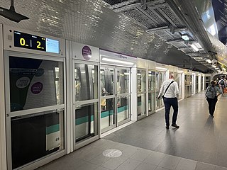
Alésia is a station of the Paris Métro on line 4 in the 14th arrondissement situated in Petit-Montrouge quarter.

<span class="mw-page-title-main">Porte d'Orléans (Paris Métro)</span>

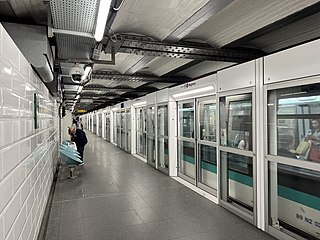
Porte d'Orléans is a station of line 4 of the Paris Métro and a stop on tramway line 3a. It is situated in the 14th Arrondissement, in the quartier of Petit-Montrouge. The station is the former southern terminus of line 4. A terminal loop was provided at the station for trains to turn around to return north towards Porte de Clignancourt. Passengers used to disembark at the arrival platform and then the train proceeded empty via the loop to the departure platform. The extension to Mairie de Montrouge modified the layout of the station, the northbound platform was extended toward the track coming from the former terminal loop to add a new entrance.
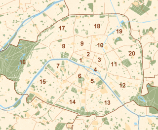
<i>Arrondissements</i> of Paris Administrative districts of the French capital

The city of Paris is divided into twenty arrondissements municipaux, administrative districts, more simply referred to as arrondissements. These are not to be confused with departmental arrondissements, which subdivide the larger French departments.

<span class="mw-page-title-main">Montrouge</span> Commune in Île-de-France, France

Montrouge is a commune in the southern Parisian suburbs, located 4.4 km (2.7 mi) from the centre of Paris. It is one of the most densely populated municipalities in Europe. After a long period of decline, the population has increased again in recent years.

<span class="mw-page-title-main">Wallace fountain</span>

Wallace Fountains are public drinking fountains named after, financed by and roughly designed by Sir Richard Wallace. The final design and sculpture is by Wallace's friend Charles-Auguste Lebourg. They are large cast-iron sculptures scattered throughout the city of Paris, France, mainly along the most-frequented sidewalks. A great aesthetic success, they are recognized worldwide as one of the symbols of Paris. A Wallace Fountain can be seen outside the Wallace Collection in London, the gallery that houses the works of art collected by Sir Richard Wallace and the first four Marquesses of Hertford.

<span class="mw-page-title-main">Denfert-Rochereau (Paris Métro)</span>

Denfert-Rochereau is a station on the Paris Métro in France. An adjacent station with the same name is served by RER B.

<span class="mw-page-title-main">Haussmann's renovation of Paris</span> Vast public works programme commissioned by Emperor Napoléon III between 1853 and 1870

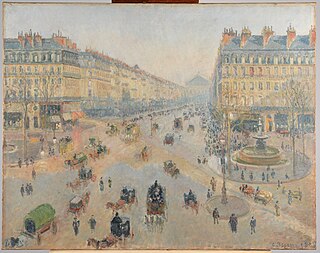
Haussmann's renovation of Paris was a vast public works programme commissioned by Emperor Napoleon III and directed by his prefect of Seine, Georges-Eugène Haussmann, between 1853 and 1870. It included the demolition of medieval neighbourhoods that were deemed overcrowded and unhealthy by officials at the time; the building of wide avenues; new parks and squares; the annexation of the suburbs surrounding Paris; and the construction of new sewers, fountains and aqueducts. Haussmann's work was met with fierce opposition, and he was finally dismissed by Napoleon III in 1870; but work on his projects continued until 1927. The street plan and distinctive appearance of the centre of Paris today are largely the result of Haussmann's renovation.

<span class="mw-page-title-main">Parc Montsouris</span> Urban park in Paris

Parc Montsouris is a public park situated in southern Paris, France. Located in the 14th arrondissement, it was officially inaugurated in 1875 after an early opening in 1869.

Wall of the <i>Ferme générale</i>

The Wall of the Ferme générale was commissioned by Antoine Lavoisier and built between 1784 and 1791 by the Ferme générale, the corporation of tax farmers. It was one of the several city walls of Paris built between the early Middle Ages and the mid 19th century. It was 24 kilometers long and roughly followed the route now occupied by line 2 and line 6 of the Métro. It crossed the districts of the Place de l'Étoile, Batignolles, Pigalle, Belleville, Nation, the Place d'Italie, Denfert-Rochereau, Montparnasse and the Trocadéro.

<span class="mw-page-title-main">Rue d'Alésia</span>

Rue d'Alésia is a major street in the south of Paris, which runs along the entire east-west length of the 14th arrondissement. It is one of the few streets in Paris named after a French defeat, or more precisely, a Gallic defeat: the Battle of Alesia. Lined with acacia trees, the street extends to the east as Rue de Tolbiac into the 13th arrondissement, and to the west as Rue de Vouillé into the 15th arrondissement. It intersects Avenue du Général Leclerc at the Place Victor et Hélène Basch, the location of the Église Saint Pierre de Montrouge, as well as of the Alésia Métro station.

<span class="mw-page-title-main">Boulevard Raspail</span>

Boulevard Raspail is a boulevard of Paris, in France.

<span class="mw-page-title-main">City gates of Paris</span>

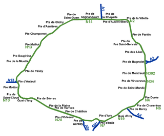
While Paris is encircled by the Boulevard Périphérique, the city gates of Paris are the access points to the city for pedestrians and other road users. As Paris has had successive ring roads through the centuries, city gates are found inside the modern-day Paris.

<span class="mw-page-title-main">Place Denfert-Rochereau</span>

Place Denfert-Rochereau, previously known as Place d'Enfer, is a public square located in the 14th arrondissement of Paris, France, in the Montparnasse district, at the intersection of the boulevards Raspail, Arago, and Saint-Jacques, and the avenues René Coty, Général Leclerc, and Denfert-Rochereau, as well as the streets Froidevaux, Victor-Considérant and de Grancey. It is one of the largest and most important squares on the left bank of the Seine.
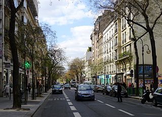
The Barrière d'Enfer is a pair of tollhouses in Paris that once served as a gate through the Wall of the Farmers-General at the current location of the Place Denfert-Rochereau.

<span class="mw-page-title-main">Auguste Balagny</span>

Auguste Prosper Balagny was a French notary and the first mayor of the 17th arrondissement of Paris.

<span class="mw-page-title-main">Faubourg Saint-Antoine</span> Faubourg in Paris, France

The Faubourg Saint-Antoine was one of the traditional suburbs of Paris, France. It grew up to the east of the Bastille around the abbey of Saint-Antoine-des-Champs, and ran along the Rue du Faubourg Saint-Antoine.

Outline of Paris Overview of and topical guide to Paris

The following outline is provided as an overview of and topical guide to Paris:

References

  1. R. Howard Bloch, God's Plagiarist : Being an Account of the Fabulous Industry and Irregular Commerce of the Abbe Migne, University of Chicago Press, 1994, p. 105.

Attribution: This article was originally a translation of this version of fr:Petit-Montrouge (quartier parisien) in the francophone Wikipedia.

[1]

[2]

[3]

[4]


Coordinates: 48°49′42.62″N2°19′37.39″E / 48.8285056°N 2.3270528°E / 48.8285056; 2.3270528

  1. https://es.wikipedia.org/wiki/Transformaciones_de_Par%C3%ADs_durante_el_Segundo_Imperio#Balance
  2. "Plan Haussmann".
  3. "Las reformas de Haussmann y los antecedentes de la Comuna de París |".
  4. John Merriman (2014) - Masacre. Vida y Muerte en la Comuna de París de 1871. Siglo XXI, Colección hitos, Madrid: 407p