Peña Montañesa

Last updated
Peña Montañesa
Toponimia Pena Montanesa.JPG
Highest point
Elevation 2,295 m (7,530 ft)
Listing List of mountains in Aragon
Coordinates 42°31′14″N00°13′55″E / 42.52056°N 0.23194°E / 42.52056; 0.23194 Coordinates: 42°31′14″N00°13′55″E / 42.52056°N 0.23194°E / 42.52056; 0.23194
Geography
Relief Map of Spain.png
Red triangle with thick white border.svg
Peña Montañesa
Spain
Location Sobrarbe (Aragon)
Parent range Sierra Ferrera
Geology
Mountain type Conglomerate
Climbing
Easiest route From Pueyo de Araguás
Exconjuratory in San Vicente de Labuerda with the Pena Montanesa towering behind it Esconjuraderosanvicentedelabuerda.jpg
Exconjuratory in San Vicente de Labuerda with the Peña Montañesa towering behind it

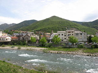
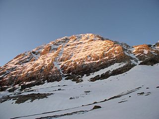
The Peña Montañesa (Aragonese : Penya Montanyesa) is a conspicuous rocky mountainous outcrop of the Pre-Pyrenees. It is located east of the valley of the Cinca, in the Sobrarbe comarca, Aragon, Spain. [1] The ridge's highest summit is 2295 m high. The village of Laspuña is located at the feet of the mountain.

Aragonese language Romance language

Aragonese is a Romance language spoken in several dialects by 10,000 to 30,000 people in the Pyrenees valleys of Aragon, Spain, primarily in the comarcas of Somontano de Barbastro, Jacetania, Alto Gállego, Sobrarbe, and Ribagorza/Ribagorça. It is the only modern language which survived from medieval Navarro-Aragonese in a form distinctly different from Spanish.

Pre-Pyrenees

The Pre-Pyrenees are the foothills of the Pyrenees.

Cinca (Spain) river in Aragon

The Cinca is a river in Aragon, Spain. Its source is in the Circo de Pineta, in the Ordesa y Monte Perdido National Park, in the Aragonese Pyrenees. It is a tributary to the Segre River, with its confluence at La Granja d'Escarp, not far from the point where the Segre flows into the Ebro River. The Cinca River flows through a rich agricultural region.

Contents

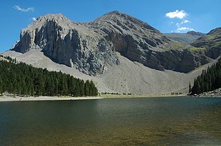
The summits on the mountain offer excellent views of some of the main peaks of the Pyrenees in the north.

Pyrenees Range of mountains in southwest Europe

The Pyrenees is a range of mountains in southwest Europe that forms a natural border between Spain and France. Reaching a height of 3,404 metres (11,168 ft) altitude at the peak of Aneto, the range separates the Iberian Peninsula from the rest of continental Europe, and extends for about 491 km (305 mi) from the Bay of Biscay to the Mediterranean Sea.

The Peña Montañesa was one of the strongholds of Spanish Republican resistance against invading troops supporting General Franco during the Bolsa de Bielsa episode. [2]

Spanish Republican Army

The Spanish Republican Army was the main branch of the Armed Forces of the Second Spanish Republic between 1931 and 1939.

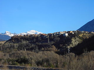
The ruins of the Real Monasterio de San Victorián are located in El Pueyo de Araguás, at the foot of the Peña Montañesa.

Real Monasterio de San Victorián monastery in Huesca, Spain

Real Monasterio de San Victorián is a monastery at the feet of Peña Montañesa, Sobrarbe, Aragon, Spain. It was established in the 11th century.

El Pueyo de Araguás Place in Aragon, Spain

El Pueyo de Araguás is a municipality located in the province of Huesca, Aragon, Spain. According to the 2004 census (INE), the municipality has a population of 151 inhabitants.

See also

Related Research Articles

Biescas Place in Aragon, Spain

Biescas is a municipality of northeastern Spain close to the border with France, in the midst of the Pyrenees in the province of Huesca. The name seems to provide from the term bizka, which means "hill" in a Proto-Indo-European language.

Sobrarbe Comarca in Aragon, Spain

Sobrarbe is one of the comarcas of Aragon, Spain. It is located in the northern part of the province of Huesca, part of the autonomous community of Aragon in Spain. Many of its people speak the Aragonese language locally known as fabla.

Peña, meaning "rocky outcrop" or "rocky summit" in the Spanish language, may refer to:

Gonzalo Sánchez was ruler of Sobrarbe and Ribagorza, two small Pyrenean counties. He was the son of King Sancho III of Pamplona and his wife, Muniadona of Castile. Before 1035, Sancho decreed that Gonzalo should rule Sobrarbe and Ribagorza. He succeeded to these domains after his father's death in that year and ruled them as vassal of his brother García Sánchez III until his death. Gonzalo is thought to have been ineffectual and unpopular, with vassals defecting to his brother, Ramiro I of Aragon, during his own life, and one failing to name him in a list of rulers of Ribagorza written within a decade of his death.

Aínsa-Sobrarbe municipality in Aragon, Spain

Aínsa-Sobrarbe is a municipality located in the province of Huesca, Aragon, Spain. As of 2010 (INE), the municipality has a population of 2,180 inhabitants.

La Fueva Place in Aragon, Spain

La Fueva is a municipality located in the province of Huesca, Aragon, western Spain. As of 2010, the municipality has a population of 619 inhabitants.

Laspuña Place in Aragon, Spain

Laspuña is a municipality located in the province of Huesca, Aragon, Spain. According to the 2004 census (INE), the municipality has a population of 271 inhabitants.

Kingdom of Sobrarbe

The Kingdom of Sobrarbe was the legendary predecessor to the Kingdom of Aragon and the modern region of Sobrarbe. According to the late medieval legend, the kingdom, with its capital at L'Aïnsa, was a product of the Reconquista. The legend is based in part on the historical origins of the Kingdom of Pamplona.

Gualberto Fabricio de Vagad Spanish historian

Gualberto Fabricio de Vagad was an Aragonese Cistercian Benedictine monk and the first historian of the Kingdom of Aragon. He was born in Zaragoza in the first third of the fifteenth century and straddles the line between the Late Middle Ages and the Renaissance. He lived most of his life at the monastery of Santa María de Santa Fe, though he also spent some time at San Juan de la Peña. According to Félix de Latassa y Ortín, besides history he wrote various treatises on poetry and a compendium of verse.

Moncayo Massif mountain massif in Spain

Moncayo is a 15 km long and about 7 km wide mountain massif giving name to the Tarazona y el Moncayo comarca, Aragon, Spain. The Moncayo's highest summit, San Miguel (2,314 m), is the highest point in the 500 km long Sistema Ibérico.

El Turbón mountain

El Turbón is a mountain massif of the Pre-Pyrenees, located in the province of Huesca, the most northerly province in the autonomous community of Aragon, Spain. This 6.3 km (4 mi) long mountain is aligned N - S.

Mountains of Sis mountain in Spain

The Mountains of Sis is a 28 km (17 mi) long mountain range of the Pre-Pyrenees. They are located between the valleys of rivers Isábena and the Escales Reservoir, Noguera Ribagorzana, in the Ribagorza comarca, Aragon, Spain. The ridge's highest summits are Pico de l´Amorriador (1791 m) and Puialto (1782 m). Other important summits are 1765 m high La Creu de Bonansa, 1490 m high Altaió d'Aulet and 1066 m high Tossal de Cornudella.

Plan, Aragon Place in Aragon, Spain

Plan is a municipality located in the Sobrarbe comarca, province of Huesca, Aragon, Spain. According to the 2010 census the municipality has a population of 336 inhabitants. Its postal code is 22367.

Pic de Marboré mountain in France and Spain

Marboré Peak is a summit in the Pyrenees located on the Franco-Spanish border crest in the Monte Perdido Range.

Pic du Taillon mountain in France

Pic du Taillon or Pico Taillón is a summit in the Pyrenees, culminating at 3,144 m (10,315 ft) on the Franco-Spanish border in the Monte Perdido Range.

Pedro de Atarés Nobleman, pretender to the throne of the Kingdom of Aragón

Pedro de Atarés was a Spanish noble and member of the House of Aragón. He founded the Veruela Abbey, the oldest Cistercian monastery in Aragon.

References