
Upper Bavaria is one of the seven administrative districts of Bavaria, Germany.
Bad Tölz-Wolfratshausen is a Landkreis (district) in Bavaria, Germany. It is bounded by Austria and the districts of Garmisch-Partenkirchen, Weilheim-Schongau, Starnberg, Munich and Miesbach.

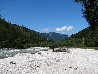
The Isar is a river in Tyrol, Austria and Bavaria, Germany. Its source is in the Karwendel range of the Alps in Tyrol; it enters Germany near Mittenwald and flows through Bad Tölz, Munich, and Landshut before reaching the Danube near Deggendorf. At 295 km (183 mi) in length, it is the fourth largest river in Bavaria, after the Danube, Inn, and Main. It is Germany's second most important tributary of the Danube after the Inn.

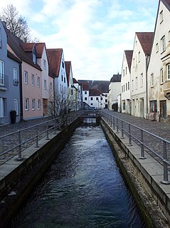
Landshut is a town in Bavaria in the south-east of Germany. Situated on the banks of the River Isar, Landshut is the capital of Lower Bavaria, one of the seven administrative regions of the Free State of Bavaria. It is also the seat of the surrounding district, and has a population of more than 70,000. Landshut is the largest city in Lower Bavaria, followed by Passau and Straubing, and Eastern Bavaria's second biggest city.

The Loisach is a river that flows through Tyrol, Austria and Bavaria, Germany. Its name might be Celtic in origin, from Proto-Celtic *lawo and *iskā, both of which mean "water". But the suffix -ach is Germanic or pre-Germanic. Another possibility would be that Lois might be cognate with basque lohi(tz) "mud, swamp". The Loisach goes through the great swamp Murnauer Moos.

Landau an der Isar is the second-largest town in the Lower Bavarian district, or Landkreis, of Dingolfing-Landau, in the state of Bavaria, Germany. It lies on the Isar River, 120 km downstream from Munich. In 2020, its population was around 14,000.

The Würm is a river in Bavaria, Germany, right tributary of the Amper. The length of the river is 39.8 kilometres (24.7 mi), or 76.3 kilometres (47.4 mi) including the Steinbach, the main feed of Lake Starnberg. It drains the overflow from Lake Starnberg and flows swiftly through the villages of Gauting, Krailling, Planegg, Gräfelfing and Lochham as well as part of Munich before joining, near Dachau, the Amper, which soon afterwards flows into the Isar and eventually flowing into the Danube. Although the Würm is not a very large river, it is well known as it gave its name to the Würm glaciation.
Pullach, officially Pullach i. Isartal, is a municipality in the district of Munich in Bavaria in Germany. It lies on the Isar Valley Railway and is served by the S 7 line of the Munich S-Bahn, at the Großhesselohe Isartalbahnhof, Pullach and Höllriegelskreuth railway stations.
The 1999 Pentecost flood was a 100-year flood around the Pentecost season in 1999 that mostly affected Bavaria, Vorarlberg and Tirol. It was caused by heavy rainfall coinciding with the regular Alpine meltwater.

The Lower Bavarian Upland, Lower Bavarian Hill Country or Lower Bavarian Hills, are part of the tertiary Hügelland or hill country south of the River Danube and cover much of the land within the Bavarian province of Lower Bavaria in southern Germany. To the north it is bordered by the Gäuboden region and the Bavarian Forest; to the south by Upper Bavaria, to the east by the Lower Inn Valley and to the west by the Franconian Jura. In the western part of the Lower Bavarian Hills lies the Hallertau, the world's largest hop-growing region. It belongs to two of officially defined natural regions in Germany: the eponymous Lower Bavarian hills and the Isar-Inn Gravel Beds (Isar-Inn-Schotterplatten) and is sub-divided into the Danube-Isar Hills (Donau-Isar-Hügelland) and the Isar-Inn Upland (Isar-Inn-Hügelland) with the River Isar as the boundary. The hills continue over the border into Austria as the Upper Austrian Hills.

The Leutascher Ache is a river of Tyrol, Austria and of Bavaria, Germany, a left tributary of the Isar.
Dorfen is a river of Bavaria, Germany. It flows into the Isar near Moosburg.

Auer Mühlbach is a river in Bavaria, Germany. It is a branch of the Isar in the southern part of Munich.

The Jachen is a river in Bavaria, Germany. It flows into Isar south of Lenggries.

The Kleine Laber is a river in Bavaria, Germany. The Kleine Laber issues into the Große Laber, which issues into the Danube River.
Moosach is a 38-kilometre-long (24 mi) left tributary of the river Isar near Munich in Bavaria, Germany. It could also be described as a tributary of the river Amper, because of the stream Mühlbach that splits away carrying about 30% of the water just before the Moosach joins the Isar. After passing through Freising, the main flow enters the Isar near Oberhummel. The Mühlbach branch continues through Moosburg and enters the Amper close to its confluence with the Isar.
Rißbach is a river of Tyrol, Austria and Bavaria, Germany. Its source is in the Karwendel mountains in Austria. It passes through the valley Rißtal, and flows into the Isar in Vorderriß, Lenggries, Germany.
Schörgenbach is a river of Bavaria, Germany. It flows into the Isar near Hallbergmoos.

Sempt is a river of Bavaria, Germany. It flows into the Mittlere-Isar-Kanal, which is connected with the Isar, west of Eching.
Strogen is a river of Bavaria, Germany. It is a right tributary of the Sempt, is approximately 40 km in length, and drains a basin of approximately 146 km2. Its source is northwest of Buch am Buchrain in the district Erding. On its way north, the river splits into a main channel and the parallel "Strogenkanal", both of which join the Sempt, a tributary of the Isar, near Moosburg.