
Mahendra Bir Bikram Shah Dev was King of Nepal from 13 March 1955 until his death in 1972, which was due to heart attack as told in an interview by his personal physician Dr. Mrigendra Raj Pandey. Following the 1960 coup d'état, he established the partyless Panchayat system which governed the country for 28 years until the introduction of multiparty democracy in 1990. During his reign, Nepal experienced a period of industrial, political and economic change that opened it to the rest of the world for the first time after the 104-year-long reign of the Rana rulers, who had kept the country under an isolationist policy, came to an end in 1951.
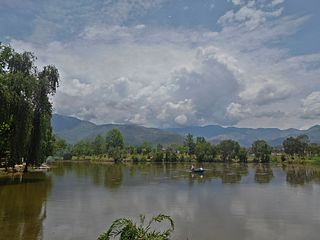
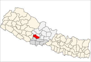
Surkhet District is a district in Karnali Province of mid-western Nepal. Surkhet is one of the ten districts of Karnali located about 600 kilometres (373 mi) west of the national capital Kathmandu. The district's area is 2,489 square kilometres (961 sq mi). It had 288,527 population in 2001 and 350,804 in 2011 which male comprised 169,461 and female 181,381. Its district headquarters, Birendranagar, is the capital of Karnali Province. It is serving as a business hub and document center for Karnali province. According to population, development, road links, landforms, climate, many peoples are migrating here. After becoming province capital developmental activities are boosted and are in peak level. All the governmental works are carried here. Birendranagar is beautiful valley surrounded by hills having moderate climate.

Takhatgarh is a town in Pali District of Rajasthan state in India. The town is one of the nine municipalities in the district, located near the district border. It is only about 160 years old.
Bikramganj is a nagar parishad city and corresponding community development block of Rohtas district, Bihar, India. At the time of the 2011 census, the city of Bikramganj had a population of 48,465, in 7,968 households, while the overall subdistrict had a population of 163,565. The main commodities produced in Bikramganj are rice and pulses. The city of Bikramganj has a slum called Dhangai which, in 2011 had a population of 3,955 in 637 households. Bikramganj is located at 25.2°N 84.25°E. It has an average elevation of 77 metres (252 feet).

Butwal, officially Butwal Sub-Metropolitan City, is a sub-metropolitan city and economic hub in Lumbini Province in West Nepal. Butwal has a city population of 195,054 as per the 2021 AD Nepal census.

Ghorahi is the largest city of Nepal and largest sub-metropolitan city by area and population of Lumbini Province. The city lies in Lumbini Province in the Mid-Western part of Nepal. It is the largest city of Dang Deukhuri District of southwest Nepal. Located in the Inner Terai region, it lies 413 kilometres (257 mi) south-west of Nepal's capital Kathmandu and is one of the Counter Magnets being developed as an alternative centre of growth to help ease the migration and population explosion in the Kathmandu metropolitan area. It is the largest city of the Rapti Zone and is surrounded by the Sivalik Hills to the south and Mahabharata Range to the north.
Triyuga is one of eight municipalities of Udayapur district of the Koshi Pradesh of Nepal. Gaighat is the headquarter of the municipality. According to the 1991 Nepal census, it had a population of 55,291. According to the 2011 Nepal census, Triyuga had 87,557 inhabitants. According to the 2021 Nepal census the initial population of the municipality is 104,375. It is divided into 16 wards. Triyuga Municipality was established on B.S. Chaitra 13, 2053. It was named after Triyuga River. A river which flows through the town. Triyuga is the 3rd largest municipality in Nepal and 1st largest in Koshi Pradesh in term of size (area). The total area of the municipality is 547.43 square kilometres (211.36 sq mi)

Janakpurdham or Janakpur is a sub-metropolitan city in Dhanusha district, Madhesh Province, Nepal. The city is a hub for religious and cultural tourism. A headquarter of Dhanusha district, Janakpur is also the capital for Madhesh Province.

Bhimeshwar,, is a municipality in north-eastern Nepal and the headquarters of Dolakha District in Bagmati Province that was established in 1997 by merging the former Village development committees Charikot, Dolakha Town, Makaibari and Mati. At the time of the 2011 Nepal census, it had a population of 32,486 people living in 8,639 individual households. The town is located at an altitude of 1,554 metres (5,101 feet). The name of the district Dolakha came from Dolakha Town situated north-east of the headquarters Charikot Bazaar.

Koteshwor is a place, located in Kathmandu District. In 1991, Kathmandu Metropolitan City was expanded by incorporating Koteshwor as Ward No. 32. It encompasses 395 hectares and is bounded by the Manohara river in the east and south, the Bagmati river in the west, and share borders with Gothatar in the north, Madhyapur Thimi municipality of Bhaktapur District in east and Lalitpur metropolitan city in the south. With respect to basic services, almost all homes in the ward have access to electricity, but the same cannot be said about drinking water. At the time of the 1991 Nepal census it had a population of 5,787 living in 1,154 households. The ward contains 8,716 households. The population in 2001 was 35,184.
Mirchaiya formerly known as Ramnagar Mirchaiya is a municipality in Siraha District in the Madhesh Province of south-eastern Nepal. The municipality was established on 18 May 2014 by merging the existing Rampur Birta, Malhaniyakhori, Radhopur, Ramnagar Mirchaiya, Phulbariya, Sitapur PraDa and Maheshpur Gamharia Village Development Committees. At the time of the 2017 municipality records, it had a population of approx. 52,000 people living in approx 8,496 individual households. This is one of the main business markets for Katari and the southern part of the Siraha district. Raw material produced here includes padday, miazem, and sugar cane.

Surunga is a trade center of Jhapa District. It is located in Kankai Municipality in Jhapa District in the Koshi Province of south-eastern Nepal. At the time of the 1991 Nepal census it had a population of 16,747 people living in 2996 individual households. Surunga is one of the rapidly developing towns of Jhapa district. It is situated on the bank of the Kankai River.

Tahoon is a village very development committee in Palpa District in the Lumbini Zone of southern Nepal. At the time of the 1991 Nepal census it had a population of 3776.
Banganga is a municipality in Kapilvastu District in the Lumbini Zone of southern Nepal. Banganga Municipality has total of 233.6 km2. According to the 2011 census, total population of the municipality is 75, 242 with population density of 322 person per km2 and density without forest is 804 persons per km2.
Madhumalla is a village development committee in Morang District in the Koshi Zone of south-eastern Nepal. With a population of 21,482 as of the 2011 Nepal census and situated at the foothills of Raja rani mountain, Madhumalla is a village sandwiched by two rivers Mawa and Nunsari. Its neighbours are Urlabari municipality to its south, Damak municipality to its east and south, and Illam district to its north. This village is at a distance of 7.3 km north of Urlabari
Bhalwari is a small town in the Rupandehi District in Nepal. It is located Tilottama municipality ward no. 9 near two larger towns, 12 km south of Butwal and 10 km north of Bhairahawa.

Kawasoti (Nepali: कावासोती) is a municipality in Nawalpur District, Gandaki Province, Nepal. It is 31 km (19 mi) west of Bharatpur and 85 km (53 mi) east of Butwal, approximately on the middle of Mahendra Highway. The Naryani River flows south of it, and the Mahabharat Range is north of it.
Thorga is a village in Gulmi district, Lumbini Zone, Nepal. It is mostly inhabited by Brahmins. The population of this village is around 1200 and literacy rate is about 35%.
Bardaghat नेपाली: बर्दघाट is a Municipality in Nawalparasi District in Lumbini Province, Nepal. It is situated in the lap of the Chure range. This municipality was established on 18 May 2014 by merging existing Makar and Panchanagar VDCs. Again during the local election, the neighbouring VDC Dawanne devi and some parts of Dhurkot, Jamuniya, and Rupauliya were merged. It has a population of 76,703 with an area of 162.05 km2. The population growth rate is 2.77%/per year. It has a LITERACY RATE of 82.05%. It is an emerging town of Nawalparasi District that is developing rapidly with tourist areas.
Gaindakot is a municipality in Nawalpur District in the Lumbini Zone of southern Nepal. It became a municipality in May 2014 by merging the existing Mukundapur, Amarapuri, and Gaindakot VDCs. It was again expanded by merging Ratanpur VDC. It is situated on the shore of Narayani River in the lap of Maula Kalika temple. So this place has a great possibility of tourism development. At the time of the 2011 Nepal census, it had a population of 58,841 and 13,623 individual households according to 2011 Nepal census. Contributed in the article by Prashant Subedi
