
Saptari, a part of Madhesh Province, is one of the seventy-seven districts of Nepal. Its district headquarter is Rajbiraj. Saptari is an Outer Terai district. This district covers an area of 1,363 km2 (526 sq mi) and has a population (2011) of 639,284 which makes it the 10th most populated district of Nepal. Saptari is renowned for its agricultural output, and is bordered on the east by the massive Sapta Koshi river.
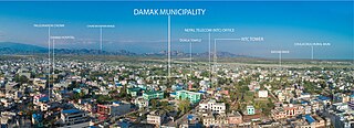
Damak, a city in eastern Nepal, is one of the oldest municipalities in Jhapa District in Koshi Province in eastern Nepal. It is situated between the Ratuwa River in the east and the Maawa River in the west. It has Sivalik Hills in its north and ends with the intersection of Ratuwa River and Maawa River in the south. Mahendra Highway, the longest highway of Nepal, bisects the municipality. It is the largest city in Jhapa District with a population of 107,410 in 2021.

A village development committee in Nepal was the lower administrative part of its Ministry of Federal Affairs and Local Development. Each district had several VDCs, similar to municipalities but with greater public-government interaction and administration. There were 3,157 village development committees in Nepal. Each village development committee was further divided into several wards depending on the population of the district, the average being nine wards.
Pagretar is a village development committee in Sindhupalchowk District in the Bagmati Zone of central Nepal. Kothe is a populated location within the committee area. In 1991, there were 633 houses, and at the time of the 2001 Nepal census Pagretar had a population of 3,352. By 2011, the population had become 2,952 in 762 households.
Phattepur is a village development committee in Banke District in Lumbini Province of south-western Nepal. At the time of the 1991 Nepal census it had a population of 10,793 and had 1586 houses in the town.
Patarasi is a rural municipality located in Jumla District of Karnali Province of Nepal.
Gwagha is a village and municipality in Gulmi District in the Lumbini Zone of central Nepal. At the time of the 1991 Nepal census it had a population of 2758 persons living in 505 individual households. It is notable for a vicious attack by tigers in 1985 in which all but three inhabitants were mauled and killed. The remaining three were left to rebuild and repopulate the municipality, saving the community, fabled for having taller women than men from extinction.

Gadhimai is a former independent municipality in Bara District in of south-eastern Nepal that was merged into Jeetpur Simara Sub-Metropolitan City on 10 March 2017. It was itself established on 18 May 2014 by merging Pipara Simara, Jitpur Bhawanipur, Chhata Pipra, Phattepur, Dumbarwana Village Development Committees.
Shisuwa is a town and once a Village Development Committee in Kaski District in the Gandaki Zone of northern-central Nepal. At the time of the 1991 Nepal census it had a population of 12,127.
Dullu is an urban Municipality in Dailekh District of Karnali Province in Nepal.
Rupakot is a village development committee in Tanahu District in Gandaki Province of central Nepal. At the time of the 1991 Nepal census it had a population of 4765 people living in 937 individual households. The VDC has been merged with existing Bhanu village development committees(VDCs), Barbhanjyang village development committees (VDCs) Tanahunsur Village Development Committee, Purkot VDC, Mirlung VDC, Satiswara VDC, Risti VDC, Basantapur VDC and Chok Chisapani VDC on 19 September 2015 to form Bhanu Municipality.
Kamalpur is a saptakoshi 9 municipality in Saptari District in the Sagarmatha Zone of south-eastern Nepal. At the time of the 2011 Nepal census it had a population of 5,334 people living in 1,038 individual households.

Prakashpur is a small town in Sunsari District in the Koshi Zone in southeastern Nepal.It lies in ward no.10 of Barahakshetra municipality.It is near the Indo-Nepal border.It is famous for its beautiful and peaceful environment. Most of the people come here to visit Koshi river which is one of the longest river in Nepal. It is also famous for its diversity in culture.
Shivanagar is a town in Krishnanagar Municipality in Kapilvastu District in the Lumbini Zone of southern Nepal. The former VDC was merged to form the municipality established on 18 May 2014 Krishnanagar, Sirsihawa, Shivanagar VDCs. At the time of the 2011 Nepal census it had a population of 4,774 people living in 735 individual households.
Shivaraj is a Municipality in Kapilvastu District in the Lumbini Zone of southern Nepal. The former village development committee was transformed into Municipality from 18 May 2014 by merging the existing Birpur, Chanai, Bishunpur,Jawabhari and Shivapur village development committees. At the time of the 1991 Nepal census it had a population of 7241 people living in 1067 individual households.
Pathari Shanishchare (पथरी-शनिश्चरे) is a Municipality in Morang District in the Koshi Zone of south-eastern Nepal. It was formed by merging three existing village development committees i.e. Hasandaha, Pathari and Sanischare in May 2014.

Urlabari is a city and municipality in Morang District in the Koshi Zone of south-eastern Nepal. It is considered to be the second largest city in Morang District after Biratnagar. At the time of the 1991 Nepal census it had a population of 18,224. At the time of the 2011 Nepal census it had a population of 35,166 and 8,165 households.
Nepal conducted a widespread national census in 2011 by the Nepal Central Bureau of Statistics. Working with the 58 municipalities and the 3,915 Village Development Committees at a district level, they recorded data from all the municipalities and villages of each district. The data included statistics on population size, households, sex and age distribution, place of birth, residence characteristics, literacy, marital status, religion, language spoken, caste/ethnic group, economically active population, education, number of children, employment status, and occupation.
Saptakoshi Municipality is located in Saptari District in the Province 2 of Nepal. It was formed in 2014 and then again modified in 2016 occupying current 11 sections (wards) from previous 11 wards. It occupies an area of 60.25 km2 (23.26 sq mi) with a total population of 21,139.

