Kampong Speu is a province (khaet) of Cambodia. It borders the provinces of Pursat and Kompong Chhnang to the north, Kandal to the east, Takéo to the southeast, Kampot to the south and Koh Kong to the west. Its capital is Chbarmorn town.

The Dâmrei Mountains, refer to a mountain range situated in south-western Cambodia, traversing around 110 km (68 mi) north-south as a succession of the Cardamom Mountains, dropping abruptly to the sea near the town of Kampot. The Elephant Mountains represent the easternmost parts of the original extent of the wet evergreen forests that include Cambodia's south and the mountains east of Bangkok in Thailand.
The Krâvanh Mountains, literally the "Cardamom Mountains", is a mountain range in the south west of Cambodia and Eastern Thailand.

Phnom Aural is the tallest peak in Cambodia. It is 1,813 meters tall. It is in the eastern part of the Cardamom Mountains. To protect the biodiversity of the mountains, Phnom Aural Wildlife Sanctuary was established.
Krong Khemarak Phoumin is the capital and largest city of Koh Kong Province in Cambodia. It is located near the mouth of the Kah Bpow river in Smach Mean Chey district on the Gulf of Thailand. The city lies only 10 kilometres from the Thai border. However, it is 138 kilometres by Highway 48 to National Highway 4 at Sre Ambel and a further 133 kilometres to Phnom Penh. After the completion of the bridges on the Highway 48 in 2007 - 2010 the terrestrial link to Phnom Penh and Sihanoukville has significantly improved.

Phnum Kravanh district is a district in Pursat Province, Cambodia. In English the name translates to the Cardamom Mountains.

Kirirom National Park and officially recognized as Preah Suramarit-Kossamak Kirirom National Park is a national park in Cambodia. It is located mostly in Phnom Sruoch District, Kampong Speu Province, while a smaller section is in neighboring Koh Kong Province.
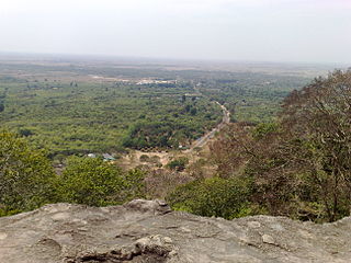
Phnom Chisor is a 133 m high hill in Dok Por village, Rovieng commune, Samraŏng District, Takéo Province, Cambodia. It rises about 42 km south of Phnom Penh.

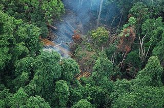
Wildlife Alliance is an international non-profit wildlife and forest conservation organization with current programs and partnerships in Cambodia. It is headquartered in New York City, with offices in Phnom Penh. The logo of the organization is the Asian elephant, an emblematic species of Southeast Asia and the namesake for the organization's programs in the Southwest Elephant Corridor of the Cardamom Mountains of Cambodia.

Phnom Samkos Wildlife Sanctuary is a 3,307.56 km2 (1,277.06 sq mi) large protected area in western Cambodia that was established in 1994. It borders Thailand in the north. It encompasses an Important Bird Area.
Phnom Santuk is a hill and cultural site in the Cambodian province of Kampong Thom. Located in Ko Koh village, Ko Koh commune, Santuk District, it is the most sacred mountain of the province. The summit is accessed by a stone pathway with many statues flanking the way. At the top is a white-walled temple and many shrines and deities, including several reclining Buddhas made out of rock, measuring more than 33 feet (10 m) in length. Monks inhabit the site.

Phnom Sorsia is a Buddhist hill complex in Kampot Province, southern Cambodia. It contains Buddhist cultural features approached by a staircase and a complex of karst caves. One cave Rung Damrey Saa has a stalagmite resembling the head of an elephant; another has a bat colony. The gateway to the caves is marked by a pagoda, approximately 1 kilometre (0.62 mi) from the main road.
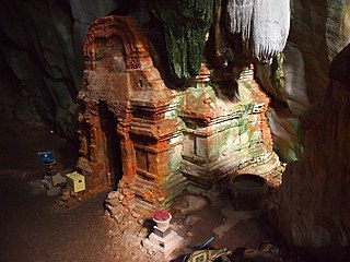
Phnom Chhnork is a Hindu cave temple in Kampot Province, southern Cambodia, located about 5 miles (8.0 km) north-east of Kampot. The temple was built in the 7th century from Funan brick, dedicated to Shiva. It is accessed view stone steps.

The killing caves of Phnom Sampeau are a Khmer Rouge execution site on Phnom Sampeau, a hill 7 mi (11 km) southwest of Battambang in western Cambodia. The Khmer Rouge killed their victims on top of the cave at the rim of a daylight shaft or ceiling hole and then threw the dead body into the cave. Men and women were placed in separate caves and clothes in another. There are a number of caves at Phnom Sampeau that have traditionally served as Buddhist temples. Today there is a large glass memorial in the cave next to the skulls and bones and a golden reclining Buddha, that can be reached via a staircase. A memorial, assembled from cyclone fencing and chicken wire contains human bones at the base of the stairway.
Moat Preah is a village in Pursat Province of western Cambodia. The village lies to the south of Tumpor and north-west of Veal Veng.
Phnom Samkos is the second-highest peak in Cambodia, located in the western Cardamom Mountains at 1,717 metres (5,633 ft) above sea level. It is situated within the Phnom Samkos Wildlife Sanctuary, which takes its name from the mountain, and the Central Cardamom Protected Forest. The elevation and surrounding forest basin support a large variety of rare flora and fauna.
The Central Cardamom Mountains is a 4,010.65 km2 (1,548.52 sq mi) large protected forest in Cambodia's Cardamom Mountains It stretches across three provinces and is flanked on each side by Phnom Samkos Wildlife Sanctuary to the west and Phnom Aural to the east.
Phnom Kmoch is a mountain peak in Pursat Province, Cambodia. It is 1,220 meters tall