Related Research Articles

Eau Claire County is a county located in the U.S. state of Wisconsin. As of the 2020 census, the population was 105,710. Its county seat is Eau Claire. The county took its name from the Eau Claire River.

Chippewa County is a county located in the U.S. state of Wisconsin. It is named for the historic Chippewa people, also known as the Ojibwe, who long controlled this territory. As of the 2020 census, the population was 66,297. Its county seat is Chippewa Falls. The county was founded in 1845 from Crawford County, then in the Wisconsin Territory, and organized in 1853.
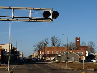
Stanley is a city in Chippewa and Clark counties in the U.S. state of Wisconsin. The population was 3,608 at the 2010 census. Of this, 3,602 were in Chippewa County, and 6 in Clark County.

Eau Claire is a city in Eau Claire and Chippewa counties in the U.S. state of Wisconsin. It is the county seat of Eau Claire County. It had a population of 69,421 in 2020, making it the state's eighth-most populous city. It is the principal city of the Eau Claire metropolitan area, locally known as the Chippewa Valley, and is also part of the larger Eau Claire–Menomonie combined statistical area.

The University of Wisconsin–Eau Claire is a public university in Eau Claire, Wisconsin. It is part of the University of Wisconsin System and offers bachelor's and master's degrees.

The Chippewa River in Wisconsin flows approximately 183 miles (294 km) through west-central and northwestern Wisconsin. It was once navigable for approximately 50 miles (80 km) of its length, from the Mississippi River, by Durand, northeast to Eau Claire. Its catchment defines a portion of the northern boundary of the Driftless Area. The river is easily accessible for bikers and pleasure seekers via the Chippewa River State Trail, which follows the river from Eau Claire to Durand.
Carson Park is a historic park located in Eau Claire, Wisconsin. It is located on a 134-acre (54.2 ha) peninsula created on an oxbow lake, Half Moon Lake, which was part of the former course of the Chippewa River. The park contains baseball, football, and softball venues, as well as the Chippewa Valley Museum.

The Eau Claire River is a tributary of the Chippewa River in west-central Wisconsin in the United States. It is one of three rivers by this name in Wisconsin. Via the Chippewa River, it is part of the Mississippi River watershed. Its name is the French translation from the Ojibwe Wayaa-gonaatigweyaa-ziibi.
The Eau Claire metropolitan area refers loosely to the urbanized area along the Chippewa and Eau Claire Rivers, in west-central Wisconsin, with its primary center at Eau Claire and secondary centers at Chippewa Falls and Altoona.

The Chippewa Valley is a valley in Wisconsin, US.

Old Abe State Trail is a 19.5-mile (31.4 km) paved multi-use rail trail in Chippewa County, Wisconsin, USA.

This is a list of the National Register of Historic Places listings in Eau Claire County, Wisconsin. It is intended to provide a comprehensive listing of entries in the National Register of Historic Places that are located in Eau Claire County, Wisconsin. The locations of National Register properties for which the latitude and longitude coordinates are included below may be seen in a map.
Putnam Park is a 230-acre (0.93 km2) state natural area owned by the University of Wisconsin–Eau Claire. The park is located in the middle of the city of Eau Claire and follows the course of both the Chippewa River to the west and Minnie Creek to the east. Much of the park lies on the boundary of the Third Ward neighborhood. The park sits directly south of a steep section of Harding Avenue, once called "Plank Street Hill."

Chippewa River State Trail is a 26-mile urban-rural rail trail in western Wisconsin that follows the path of the Chippewa River. The trails runs from the spot of the confluence of the Chippewa with the Eau Claire River, at Phoenix Park in downtown Eau Claire, meeting up with the Red Cedar State Trail near Red Cedar, to Durand. A former railroad corridor, the trail passes through a variety of habitat including wetlands, prairies and sandstone bluff.
The 31st Senate District of Wisconsin is one of 33 districts in the Wisconsin Senate. Located in western Wisconsin, the district comprises all of Eau Claire County, southeast Dunn County, and parts of southern Chippewa County and northern Trempealeau County. It includes the cities of Eau Claire, Chippewa Falls, and Menomonie.

St. Patrick's Church is a historic Catholic church built in 1885 in Eau Claire, Wisconsin. It was added to the National Register of Historic Places in 1983 for its architectural significance.

Lake Altoona, is a man-made lake in Eau Claire County, Wisconsin, United States, bordering the city of Altoona, Wisconsin, and to the east of Eau Claire.
Eau Claire Dam is a dam in Eau Claire County, Wisconsin, United States.
The Phoenix Manufacturing Company, later the Phoenix Steel Company, was one of Eau Claire, Wisconsin's oldest manufacturing firms. It manufactured equipment predominantly for the sawmill and logging equipment industries, which were vital to the establishment and growth of Eau Claire.
References
- ↑ "The Project for Public Spaces". The Project for Public Spaces. Retrieved 8 September 2014.
- 1 2 Schuh, James. "Historic American Engineering Record: Phoenix Manufacturing Company" (PDF). Library of Congress. US National Park Service: Department of the Interior. Retrieved 9 September 2014.
- 1 2 "DNR - North Barstow Redevelopment" (PDF). WI DNR. Retrieved 8 September 2014.
- ↑ "National Register of Historic Places". National Register of Historic Places. Retrieved 9 September 2014.
- ↑ "Public Access Lands Mapping Application | Real Estate Program | Wisconsin DNR".
- ↑ "CIty of Eau Claire TIF #8". City of Eau Claire. Retrieved 8 September 2014.