
Phoenixville is a borough in Chester County, Pennsylvania, United States, 28 miles (45 km) northwest of Philadelphia, at the junction of French Creek with the Schuylkill River. It is in the Philadelphia Metro Area. The population is 16,440 as of the 2010 Census. As noted by Forbes, Phoenixville is a former beaten-down mill town with a recent downtown revitalization plan that led to 10 craft breweries, a distillery, and winery tasting rooms.

The Schuylkill River is a river running northwest to southeast in eastern Pennsylvania, which was improved by navigations into the Schuylkill Canal. Several of its tributaries drain major parts of the center-southern and easternmost Coal Regions in the state. It flows for 135 miles (217 km) from Pottsville to Philadelphia, where it joins the Delaware River as one of its largest tributaries.

The Union Canal was a towpath canal that existed in southeastern Pennsylvania in the United States during the 19th century. First proposed in 1690 to connect Philadelphia with the Susquehanna River, it ran approximately 82 mi from Middletown on the Susquehanna below Harrisburg to Reading on the Schuylkill River.
The Schuylkill Expressway, locally known as "the Schuylkill", is a two to eight lane freeway through southwestern Montgomery County and the city of Philadelphia in Philadelphia County, and the easternmost segment of Interstate 76 (I-76) in the U.S. state of Pennsylvania. It extends from the Valley Forge exit of the Pennsylvania Turnpike in King of Prussia, paralleling its namesake Schuylkill River for most of the route, southeast to the Walt Whitman Bridge over the Delaware River in South Philadelphia. It serves as the primary corridor into Philadelphia from points west. Maintenance and planning are administered through Pennsylvania Department of Transportation (PennDOT) District 6, with the Delaware River Port Authority (DRPA) maintaining the approach to the Walt Whitman Bridge.
The Schuylkill Valley Metro (SVM) is a proposed 62-mile inter-city train service that would link Philadelphia, Pennsylvania with the city of Reading, Pennsylvania in central Berks County, using the Norfolk Southern Harrisburg Line, currently used for freight, with the first proposals using the SEPTA Manayunk/Norristown Line and Cynwyd Line. The original proposal was rejected by the Federal Transit Administration, however, in March 2021, Amtrak included service from Reading to Philadelphia in its Amtrak Connects US plan. Amtrak's proposal is for three daily roundtrips with stops in Bridgeport, King of Prussia, Phoenixville and Pottstown. Trains would access 30th Street Station directly via the Harrisburg Line and the Zoo Junction, bypassing all SEPTA territory. Amtrak has yet to receive funding for the proposal.
The Schuylkill Canal, or Schuylkill Navigation, was a system of interconnected canals and slack-water pools along the Schuylkill River in the U.S. state of Pennsylvania, built as a commercial waterway in the early 19th-century. Chartered in 1815, the navigation opened in 1825 to provide transportation and water power. At the time, the river was the least expensive and most efficient method of transporting bulk cargo, and the eastern seaboard cities of the U.S. were experiencing an energy crisis due to deforestation. It fostered the mining of anthracite coal as the major source of industry between Pottsville and eastern markets. Along the tow-paths, mules pulled barges of coal from Port Carbon through the water gaps to Pottsville; locally to the port and markets of Philadelphia; and some then by ship or through additional New Jersey waterways, to New York City markets.
Fitzwater Station was a stop on the anti-slavery Underground Railroad. Located in Port Providence, Pennsylvania, United States, it is now a restaurant and bar. "The Fitz" overlooks the Schuylkill Canal.

Wiconisco Creek is a tributary of the Susquehanna River in Schuylkill and Dauphin counties, Pennsylvania, in the United States. It is approximately 45.5 miles (73.2 km) long.

The Perkiomen Trail is a 19-mile-long (31 km) multi-use rail trail along the Perkiomen Creek in Pennsylvania.

The Schuylkill River Trail is a multi-use trail along the banks of the Schuylkill River in southeastern Pennsylvania. Partially complete as of 2018, the trail is ultimately planned to run about 140 miles (230 km) from the river's headwaters in Schuylkill County to Fort Mifflin in Philadelphia.

French Creek, once known as Saukanac Creek, is a 22.6-mile-long (36.4 km) tributary of the Schuylkill River in Berks and Chester counties, Pennsylvania, in the United States. The water course was also known as the Vincent River, after Sir Mathias Vincent, who purchased land along it in Chester County in 1686.
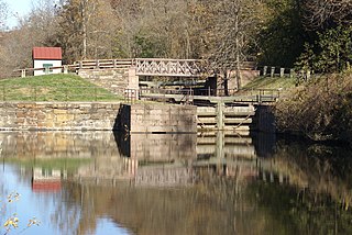
Mont Clare is a village in Upper Providence Township, Montgomery County, Pennsylvania, United States. The village is located on the left bank of the Schuylkill River, opposite Phoenixville and Chester County. Mont Clare is at the site of the former Jacobs' ford. Mont Clare hosts the only functional lock and one of only two remaining watered stretches of the Schuylkill Canal. Mont Clare was the birthplace of the infamous outlaw Sundance Kid.

The Phoenix Iron Works, located in Phoenixville, Pennsylvania, was a manufacturer of iron and related products during the 19th century and early 20th century. Phoenix Iron Company was a major producer of cannons for the Union Army during the American Civil War. The company also produced the Phoenix column, an advance in construction material. Company facilities are a core component of the Phoenixville Historic District, a National Register of Historic Places site that was in 2006 recognized as a historic landmark by ASM International.

The Harrisburg Subdivision is a railroad line owned by CSX Transportation in the U.S. state of Pennsylvania. The line is located in the city of Philadelphia, connecting Greenwich Yard and the Philadelphia Subdivision with the Trenton Subdivision along a former Pennsylvania Railroad line. Much of the Harrisburg Subdivision is the High Line or West Philadelphia Elevated along 31st Street over the 30th Street Station area.

The West Philadelphia Elevated, also known as the High Line or Philadelphia High Line, is a railroad viaduct in the western part of Philadelphia, Pennsylvania. The 8,140-foot (2,480 m) structure spans the railway lines of 30th Street Station, parallel to the main track of the station, in a north-south direction. The 1,045-foot (319 m) long approach made of brick arches is the longest brick bridge and probably even the longest brick building in the United States.

The Schuylkill Branch was a rail line owned and operated by the former Pennsylvania Railroad in the U.S. state of Pennsylvania. The line ran from the Philadelphia to Harrisburg Main Line at 52nd Street in Philadelphia north via Norristown, Reading, and Pottsville to Delano Junction. From Delano Junction, the PRR had trackage rights over the Lehigh Valley Railroad's Hazleton Branch and Tomhicken Branch to Tomhicken, where the PRR's Catawissa Branch began. In conjunction with the Catawissa Branch, Nescopeck Branch, and Wilkes-Barre Branch, the Schuylkill Branch gave the PRR a direct line from Philadelphia to Wilkes-Barre.
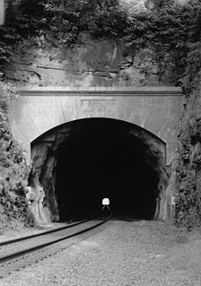
The Black Rock Tunnel is an active rail road tunnel of the old Reading Railroad. The 1835 tunnel was the third rail tunnel constructed in the United States, and is the third oldest still in use. The tunnel is also notable as being the first for which shafts were sunk during construction. The tunnel is cut through a hill in Phoenixville, Pennsylvania, United States. The tunnel and line are now owned by Norfolk Southern as part of its Harrisburg Line.

Spring Garden Street Bridge is a highway bridge in Philadelphia, Pennsylvania, USA, that crosses the Schuylkill River below Fairmount Dam. It connects West Philadelphia to the Philadelphia Museum of Art and Benjamin Franklin Parkway. It is the fourth bridge at this location.
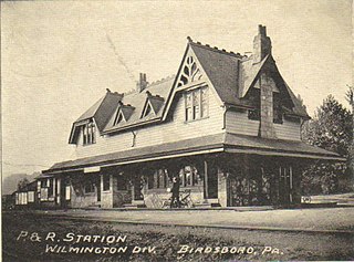
Birdsboro station can refer to three passenger railway stations in or near Birdsboro, Pennsylvania.


