
Montolieu is a commune in the Aude department in southern France.

Son River is a perennial river located in central India. It originates near Amarkantak Hill in Annupur district of Madhya Pradesh and finally merges with the Ganges river near Patna in Bihar. Sone river is the southern and second-largest tributary of the Ganges' after Yamuna River. India's oldest river bridge Koilwar Bridge over Sone river connects Arrah with Patna.

Weedon Bec, usually just Weedon, is a large village and parish in West Northamptonshire, England. It lies close to the source of the River Nene. The population of the civil parish as of the 2011 census is 2,706.
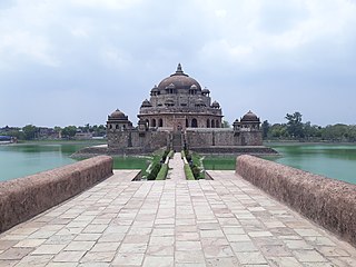
Sasaram sometimes also spelled as Sahasram, is a city in Bihar state of India. In ancient time it was a gateway of "Vihar" to visit Gaya, Rajgriha and Nalanda area and during prehistoric period Buddha has passed through this way to be enlightened with verity & wisdom under Mahabodhi tree in Gaya.

Arrah (Ara) is a city and a municipal corporation in Bhojpur district in the Indian state of Bihar. The name is also sometimes transliterated as Ara. It is the headquarters of Bhojpur district, located near the confluence of the Ganges and Sone rivers, some 24 mi (39 km) from Danapur and 36 mi (58 km) from Patna.

Velachery is a commercial and residential area in south Chennai, and is the largest commercial centre in south Chennai. It is surrounded by Guindy in the north, IIT Madras in the north-east, Taramani in the east, Perungudi in the south-east, Pallikaranai Wetland in the south, also Madipakkam in the south and south-west, Adambakkam in the west and north-west. The growth of the neighbourhood during the last decade can be cited due to the growth of the IT sector in south Chennai. It acts as an important hub connecting the rapidly growing business-class information technology corridor popularly called the OMR; the more mature and well-connected GST road and the central business districts of the city, which has more relevance to the history of Chennai. Velachery as a whole draws a perfect balance between old and new Chennai and is a phenomenon in terms of growth and development.

Stockton is a village and civil parish, in the Stratford-on-Avon district of Warwickshire, England. In the 2001 census it had a population of 1,391, falling to 1,347 at the 2011 Census. The village is located just to the east of the A426 road two miles north-east of Southam, and eight miles south-west of Rugby.

Bansagar or Ban Sagar Dam is a multipurpose river Valley Project on Sone River situated in the Ganges Basin in Madhya Pradesh, India with both irrigation and 435 MW of hydroelectric power generation.
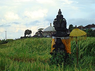
Subak is the water management (irrigation) system for the paddy fields on Bali island, Indonesia. It was developed in the 9th century. For the Balinese, irrigation is not simply providing water for the plant's roots, but water is used to construct a complex, pulsed artificial ecosystem. The system consists of five terraced rice fields and water temples covering nearly 20,000 hectares. The temples are the main focus of this cooperative water management, known as subak.

Behea or Bihiya is a nagar panchayat town in Bhojpur district in the Indian state of Bihar, as well as an associated sub-district.The sub-district comprises 76 rural villages, along with the town of Bihiya itself and 22 uninhabited villages. As of 2011, the population of the sub-district was 151,722, of whom 26,707 lived in the town of Bihiya itself.

Koilwar is a nagar panchayat town and corresponding community development block in Bhojpur district in the Indian state of Bihar. As of 2011, the population of Koilwar town was 17,725, in 2,893 households. It lies on the Arrah-Patna railway route. It is one of the 14 blocks under Bhojpur district.

Nasriganj is a nagar panchayat town and corresponding community development block situated in Rohtas District of Bihar, India. Located on the banks of the Son River, the town was a vibrant economic hub in the late 19th century. The town of Nasriganj had a population of 23,819, according to the 2011 Census of India, while the total population of Nasriganj block was 115,117. Besides the town of Nasriganj itself, the block consisted of 53 villages, of which 50 were inhabited and 3 were uninhabited.
Maudihan is a village in the Rohtas District of Bihar state, India. It is 14 km north of Dehri-On-Sone, an industrial city. It is located on Dehri-Patna road. It is also referred to as 'Maudiha'.

Koilwar Bridge, at Koilwar in Bhojpur spans the Sone river. This 1.44 Km long rail-cum-road bridge connects Arrah with Patna, the capital of Bihar state in India. The bridge is named after Indian academic and social reformer Prof. Abdul Bari, and is presently the oldest operational railway bridge in India standing since 04 November 1862. It is shown in the 1982 Oscar award winning film Gandhi, directed by Richard Attenborough. From 1862 to 1900, Koilwar bridge remained as the longest river bridge in India.

Abdul Qaiyum Ansari was a participant in the freedom struggle of India. He was known for his commitment to national integration, secularism and communal harmony. He was a leader who worked against the demand of Muslim league for creation of a separate Muslim nation from India as an independent state. Mr. Ansari has been sold the All India Momin Conference for his personal political ambitions. After that, he became cabinet minister before independence in the interim government.

Pul Kanjri is a historical site situated 35 km away from Amritsar on Amritsar-Lahore road, near the villages of Dhanoa Khurd and Dhanoa Kalan on the Wagah border. It is one of the heritage sites built by Maharaja Ranjit Singh, where he used to rest while travelling with his troops. During his reign, Pul Kanjari was an important trading centre. The legend has it when Maharaja Ranjit Singh married Begum Gul Bahar, on their way to Lahore they had to cross this canal on Ravi river. People used to cross the canal by foot but Begum Gul Bahar refused to do so. Since Maharaja Ranjit Singh was deeply in love with Begum Gul Bahar, he had a small bridge built for her. Some part of the bridge still exists. It was named Pul Kanjri. It was grately in news during 1971 war. This fortress also contains a bathing pool, a temple, a Gurudwara and a mosque.
Ekwari is a village in the Sahar Block of the Bhojpur district and belongs to the Patna division in the Indian state of Bihar.
Kaler is a block of Arwal district, Bihar state, India. It consist of 15 panchayats. NH139 passes through it.
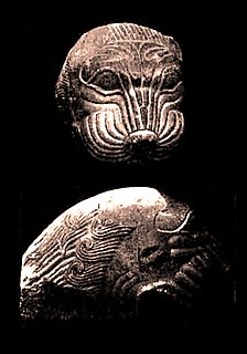
Masarh or Masar is a village situated 10 km west of Arrah in Bhojpur district of Bihar. It is an important historical site for Jains and Hindus.
New Koilwar Bridge, at Koilwar in Bhojpur is a 1.52 km long, 6 lane road bridge over the Sone river. It connects Arrah with Patna, the capital of Bihar state in India and also carries Buxar-Arrah-Patna national highway (NH-922). New Koilwar Bridge is named after Indian mathematician and Padma Shri awardee Vashishtha Narayan Singh (1946-2019). New Koilwar Bridge is 500 metres north and parallel to the existing Koilwar Bridge.

