Related Research Articles

Xishuangbanna, sometimes shortened to Banna, is an autonomous prefecture for Dai people in the extreme south of Yunnan Province, China, bordering both Myanmar and Laos. The prefectural seat is Jinghong, the largest settlement in the area and one that straddles the Mekong, called the "Lancang River" in Chinese.
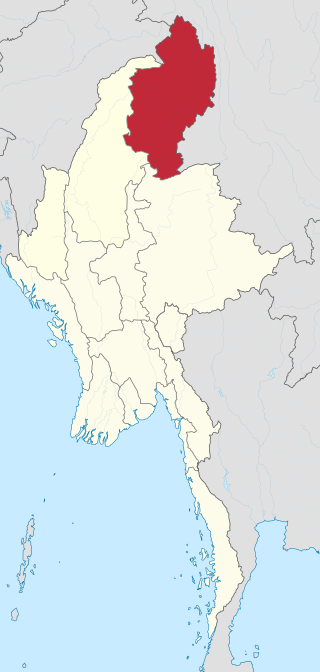
Kachin State is the northernmost state of Myanmar. It is bordered by China to the north and east, Shan State to the south, and Sagaing Region and India to the west. It lies between north latitude 23° 27' and 28° 25' longitude 96° 0' and 98° 44'. The area of Kachin State is 89,041 km2 (34,379 sq mi). The capital of the state is Myitkyina. Other important towns include Bhamo, Mohnyin and Putao.

Kokang is a region in Myanmar. It is located in the northern part of Shan State, with the Salween River to its west, and sharing a border with China's Yunnan Province to the east. Its total land area is around 1,895 square kilometers (732 sq mi). The capital is Laukkai. Kokang is mostly populated by Kokang Chinese, a Han Chinese group living in Myanmar.

The Dehong Dai and Jingpo Autonomous Prefecture is an autonomous prefecture in western Yunnan province, China. It is bordered by Baoshan to the east and Myanmar's Kachin State to the west. Its titular ethnic minorities are the Dai and Jingpo, who make up 28 and 11 percent of the prefecture's population, respectively.
The Kachin Hills are a heavily forested group of highlands in the extreme northeastern area of the Kachin State of Burma. It consists of a series of ranges running mostly in a N/S direction, including the Kumon Bum subrange of which the highest peak is Bumhpa Bum with an elevation of 3,411 metres (11,191 ft) one of the ultra prominent peaks of Southeast Asia.

The Shan States (1885–1948) were a collection of minor Shan kingdoms called muang whose rulers bore the title saopha in British Burma. They were analogous to the princely states of British India.

The Convention between the United Kingdom and China, Respecting an Extension of Hong Kong Territory, commonly known as the Convention for the Extension of Hong Kong Territory or the Second Convention of Peking, was a lease and unequal treaty signed between Qing China and the United Kingdom in Peking on 9 June 1898, leasing to the United Kingdom for 99 years, at no charge, the New Territories and northern Kowloon, including 235 islands.
The Tibetan sovereignty debate refers to two political debates. The first political debate is about whether or not the various territories which are within the People's Republic of China (PRC) that are claimed as political Tibet should separate themselves from China and become a new sovereign state. Many of the points in this political debate rest on the points which are within the second historical debate, about whether Tibet was independent or subordinate to China during certain periods of its recent history.

Tusi, often translated as "headmen" or "chieftains", were hereditary tribal leaders recognized as imperial officials by the Yuan, Ming, and Qing dynasties of China, and the Later Lê and Nguyễn dynasties of Vietnam. They ruled certain ethnic minorities in central China, western China, southwestern China, and the Indochinese peninsula nominally on behalf of the central government. As succession to the Tusi position was hereditary, these regimes effectively formed numerous autonomous petty dynasties under the suzerainty of the central court. This arrangement is known as the Tusi System or the Native Chieftain System. It should not be confused with the Chinese tributary system or the Jimi system.
Yingjiang County is a county in Dehong Prefecture, Yunnan province, China, bordering Burma's Kachin State to the west.

Lushui is a county-level city in and the seat of Nujiang Prefecture, western Yunnan Province, China. It borders Myanmar's Kachin State to the west and occupies the southern fifth of Nujiang Prefecture.
The Sino-Burmese War, also known as the Qing invasions of Burma or the Myanmar campaign of the Qing dynasty, was a war fought between the Qing dynasty of China and the Konbaung dynasty of Burma (Myanmar). China under the Qianlong Emperor launched four invasions of Burma between 1765 and 1769, which were considered one of his Ten Great Campaigns. Nonetheless, the war, which claimed the lives of over 70,000 Chinese soldiers and four commanders, is sometimes described as "the most disastrous frontier war that the Qing dynasty had ever waged", and one that "assured Burmese independence". Burma's successful defense laid the foundation for the present-day boundary between the two countries.

The Wa States was the name formerly given to the Wa Land, the natural and historical region inhabited mainly by the Wa people, an ethnic group speaking an Austroasiatic language. The region is located to the northeast of the Shan States of British Burma, in the area of present-day Shan State of northern Burma (Myanmar) and the western zone of Pu'er Prefecture, Yunnan, China.
Chashan is a Burmish language spoken in Pianma Township (片马镇), Lushui County, Yunnan, China, in Xiapianma (下片马), Gangfang (岗房), and Gulang (古浪) villages. It is closely related to Lashi, and has 56.3% lexical similarity with Lashi of Lushui County out of a sample of 1,000 vocabulary words.

The China–Myanmar border is the international border between the territory of the People's Republic of China and Myanmar. The border is 2,129 km (1,323 mi) in length and runs from the tripoint with India in the north to the tripoint with Laos in the south.
Yunnan is a de jure province in the Republic of China according to the ROC law, as the ROC government formally claims to be the legitimate government of the whole China. It was one of the 22 provinces set up during the Qing dynasty. As one of the 6 provinces in South China, the territory it administers was slightly larger than the present-day Yunnan.

Jiangxinpo was an area currently in Kachin State, Myanmar, located between the N'Mai and Mali Rivers, west of the Gaoligong Mountains of Yunnan, China. It was previously under the rule of the Qing dynasty of China.

Namwan Assigned Tract, also known as Meng-Mao Triangular Area, is a 220 km2 (85 sq mi) area situated at the junction of the Shweli River and Namwan River in the southern Kachin State of Myanmar. It was the territory of China but "perpetual lease" to British Burma in 1897, and legally became the territory of Burma in 1961.

The Chiefdom of Mengmao, officially Mengmao Anfusi (猛卯安撫司) was a Dai autonomous Tusi chiefdom in the west of Yunnan, China from 1611 to 1955.

This article is about territorial disputes of the People's Republic of China (PRC). A territorial dispute is a disagreement over the possession or control of land between two or more political entities. Many of these territorial disputes are almost identical to those that the Republic of China (ROC) based in Taipei, also known as Taiwan, has with other countries. Therefore, many of the subsequent resolved disputes made by the PRC after 1949 with other governments may not be recognized by the ROC.
References
- 1 2 Gillogly, Kathleen (2006). "Transformations of Lisu Social Structure Under Opium Control and Watershed Conservation in Northern Thailand" (PDF). evols.library.manoa.hawaii.edu. University of Hawaiʻi at Mānoa. Archived from the original (PDF) on 2013-09-21. Retrieved 2020-09-13.
... two headmen in a tusi domain who were both Han but had been brought up in Kachin society complained of the tusi to Chinese authorities. When their case failed, they petitioned the British authorities to recognize Pianma as being under British jurisdiction. The British accepted and sent troops to protect the village...British troops occupied the territory and stationed garrisons...
- 1 2 3 "Yunnan | province, China". Encyclopedia Britannica . Retrieved 2023-10-30.
In 1910 the British, then established in Burma, induced the tusi of Pianma (Hpimau) to defect from the central Chinese government, and they then occupied his territory in northwestern Yunnan. Britain also forced China to give up a tract of territory in what is now the Kachin state of Myanmar (1926–27), as well as the territory in the Wa states (1940).
- 1 2 3 4 "International Boundary Study No. 42 – Burma-China Boundary" (PDF). US DOS. 30 November 1964. p. 11. Archived from the original (PDF) on 31 January 2020. Retrieved 17 September 2020.
1961 agreements remove the causes of boundary friction between Burma and the Communist regime on the Chinese mainland. They do not eliminate the dispute between Burma and the Republic of China
- ↑ "International Boundary Study No. 42 – Burma-China Boundary" (PDF). USDOS. 30 November 1964. Archived from the original (PDF) on 31 January 2020. Retrieved 17 September 2020.
Agreement on the Question of the Boundary signed on January 28, 1960...(b) the villages of Hpimaw, Gawlum, and Kangfang would be Chinese;...(d) the Panhung-Panlao tribal area would be exchanged (for Namwan); and (e) with the exception of d, the 1941 boundary in the Wa states would be accepted...
- ↑ "Lúshuǐ Xiàn Piànmǎ Zhèn Gǔlàng Cūnwěihuì" 泸水县片马镇古浪村委会 [Gulang Village Committee, Pianma Town, Lushui County]. ynszxc.gov.cn (in Chinese). Archived from the original on 2015-04-03.