Related Research Articles

North Londonderry Township is a township in Lebanon County, Pennsylvania, United States. It is part of the Lebanon, PA Metropolitan Statistical Area. The population was 8,068 at the 2010 census.

Massachusetts's 7th congressional district is a congressional district located in eastern Massachusetts, including roughly three-fourths of the city of Boston and a few of its northern and southern suburbs. Massachusetts congressional redistricting after the 2010 census changed the borders of the district starting with the elections of 2012, with most of the old 7th district redistricted to the new 5th district. Most of the old 8th district now comprises the new 7th district. The seat is currently held by Ayanna Pressley.
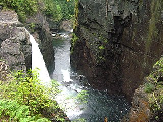
Elk Falls Provincial Park is a provincial park in British Columbia, Canada. It is 1,807 hectares in size and is located at the east end of John Hart Lake on the northwest side of the city of Campbell River, on Vancouver Island.
Thurston Bay Marine Provincial Park is a provincial park on the northwest side of Sonora Island in British Columbia, Canada.
Tranquil Creek Provincial Park is a provincial park in British Columbia, Canada, located at the head of the Kennedy River, east of the head of Bedwell Sound on Vancouver Island.

Nová Polhora is a village and municipality in Košice-okolie District in the Kosice Region of eastern Slovakia.

Rokytov is a village and municipality in Bardejov District in the Prešov Region of north-east Slovakia.
The Upper Similkameen Indian Band or Upper Smelqmix, is a First Nations band government in the Canadian province of British Columbia, whose head offices are located in town of Hedley in the Similkameen Country. They are a member of the Okanagan Nation Alliance.
The Kluskus First Nation is the band government of the Lhoosk’uz, a Dakelh people whose main reserve located on the Chilcotin Plateau 130 km west of the city of Quesnel, British Columbia, Canada. The First Nation is a member of the Carrier-Chilcotin Tribal Council, which includes both Tsilhqot'in and Carrier (Dakelh) communities.
The Tŝideldel First Nation is the band government of the Tsi Del Del subgroup of the Tsilhqot'in people, located in the Chilcotin District in the western Central Interior region of the Canadian province of British Columbia. It is a member of the Tsilhqot'in National Government.
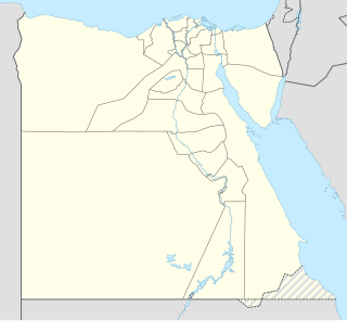
Manfalut is a city in Egypt. It is located on the west bank of the Nile, in the Asyut Governorate. The city is at 350 km south of Cairo. In 2006 it had a population of 82,585 people.

Valle de Oca is a municipality located in the province of Burgos, Castile and León, Spain. According to the 2004 census (INE), the municipality has a population of 226 inhabitants.

Santaliestra y San Quílez, in Aragonese: Santa Llestra y Sant Quílez, is a municipality located in the province of Huesca, Aragon, Spain. According to the 2004 census (INE), the municipality has a population of 102 inhabitants.

Karadzor is a town in the Lori Province of Armenia.
Fuckersberg is a populated place (Ortschaft) in the municipality of Zell an der Pram, Schärding District in Upper Austria, Austria. As of 1 January 2019, population was 21.

Da Qaidam is an administrative committee in Haixi Prefecture in northwestern Qinghai province, China. It borders Gansu province to the north.
Jan de Bakker's Kill is a 7.1-mile-long (11.4 km) tributary of Catskill Creek, part of the Hudson River watershed, in the Catskill Mountains of New York.
Strobilos, modern Aspat or Çıfıt Kalesi, is a Byzantine-era fortress on the south-western Anatolian coast, across from the island of Kos and near modern Bodrum in Turkey.
Marikoppa is a mountain, 1,840 metres (6,040 ft), between Larssen and Paulsen Peak in the Allardyce Range of South Georgia. The name, which is known locally, was used in 1950 by H.B. Paulsen. Koppa is a descriptive Finnish word meaning "basket with a lid on top." The mountain was surveyed by the South Georgia Survey in 1951–52.

Makat, also known as Maqat is a town in Atyrau Region, west Kazakhstan. It lies at an altitude of 22 m (72 ft) below sea level. It has a population of 14,082.
References
- ↑ "Pianola ca. 726 m". geonames.org. Retrieved 2009-04-06.
Coordinates: 42°19′00″N13°24′00″E / 42.31667°N 13.4°E
| This Abruzzo location article is a stub. You can help Wikipedia by expanding it. |