Mont Blanc, meaning "White Mountain", is the highest mountain in the Alps and the highest in Europe west of Russia's Caucasus peaks. It rises 4,808.7 m (15,777 ft) above sea level and is ranked 11th in the world in topographic prominence. The mountain stands in a range called the Graian Alps, between the regions of Aosta Valley, Italy, and Savoie and Haute-Savoie, France. The location of the summit is on the watershed line between the valleys of Ferret and Veny in Italy and the valleys of Montjoie, and Arve in France, in the middle of what is generally considered to be the border between the two countries.

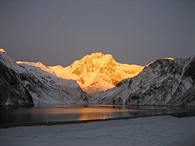
Annapurna is a massif in the Himalayas in north-central Nepal that includes one peak over 8,000 metres (26,000 ft), thirteen peaks over 7,000 metres (23,000 ft), and sixteen more over 6,000 metres (20,000 ft). The massif is 55 kilometres (34 mi) long, and is bounded by the Kali Gandaki Gorge on the west, the Marshyangdi River on the north and east, and by Pokhara Valley on the south. At the western end the massif encloses a high basin called the Annapurna Sanctuary. Annapurna I Main is the tenth highest mountain in the world at 8,091 metres (26,545 ft) above sea level, and was the first of the Eight-thousanders to be climbed.
The Vosges are a range of low mountains in eastern France, near its border with Germany. Together with the Palatine Forest to the north on the German side of the border, they form a single geomorphological unit and low mountain range of around 8,000 km2 (3,100 sq mi) in area. It runs in a north-northeast direction from the Burgundian Gate to the Börrstadt Basin, and forms the western boundary of the Upper Rhine Plain.
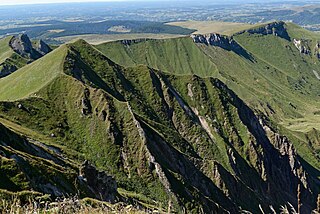
The Massif Central is a highland region in the middle of Southern France, consisting of mountains and plateaus. It covers about 15% of mainland France.

The Diablerets are a huge ice-covered mountain massif of the Alps, culminating at the Sommet des Diablerets at 3,210 metres (10,530 ft) above sea level and straddling the border between the Swiss cantons of Vaud (VD) and Valais (VS). The northeastern part of the massif stretches also into the canton of Bern (BE).

North Twin (Peak) is one of the two peaks that comprise The Twins massif located at the northeast corner of the Columbia Icefield in Jasper National Park, Alberta, Canada. The other lower peak is named South Twin. North Twin is the third-highest peak in the Canadian Rockies, after Mount Robson and Mount Columbia.

Mount Tatlow is one of the principal summits of the Chilcotin Ranges subdivision of the Pacific Ranges of the Coast Mountains of southern British Columbia. Standing on an isolated ridge between the lower end of Chilko Lake and the Taseko Lakes, it is 3,063 m (10,049 ft) in elevation.

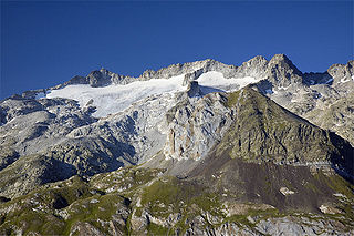
The Mont Blanc massif is a mountain range in the Alps, located mostly in France and Italy, but also straddling Switzerland at its northeastern end. It contains eleven major independent summits, each over 4,000 metres (13,123 ft) in height. It is named after Mont Blanc, the highest point in western Europe and the European Union. Because of its considerable overall altitude, a large proportion of the massif is covered by glaciers, which include the Mer de Glace and the Miage Glacier – the longest glaciers in France and Italy, respectively.

The Dents du Midi are a multi-summited mountain situated in the Chablais Alps in the Swiss canton of Valais. They are composed of seven distinct summits and reach a height of 3257 metres. Highest mountain between Lake Geneva and the Mont Blanc Massif, they dominate the Val-d'Illiez and the Rhône Valley, from Martigny down to the lake. Together with the slightly lower Tour Sallière, they form a cirque around the Lac de Salanfe, an artificial reservoir. Geologically it makes up a part of the massif Haut-Giffre.

The Cordillera Occidental is the lowest in elevation of the three branches of the Colombian Andes. The average altitude is 2,000 m (6,600 ft) and the highest peak is Cerro Tatamá at 4,100 m (13,500 ft). The range extends from south to north dividing from the Colombian Massif in Nariño Department, passes north through Cauca, Valle del Cauca, Risaralda, Chocó, and Caldas Departments to the Paramillo Massif in Antioquia and Córdoba Departments. From this massif the range divides further to form the Serranías de Ayapel, San Jerónimo and Abibe. Only to recede into the Caribbean plain and the Sinú River valley.

The Mount Meager massif is a group of volcanic peaks in the Pacific Ranges of the Coast Mountains in southwestern British Columbia, Canada. Part of the Cascade Volcanic Arc of western North America, it is located 150 km (93 mi) north of Vancouver at the northern end of the Pemberton Valley and reaches a maximum elevation of 2,680 m (8,790 ft). The massif is capped by several eroded volcanic edifices, including lava domes, volcanic plugs and overlapping piles of lava flows; these form at least six major summits including Mount Meager which is the second highest of the massif.

The La Plata Mountains are a small subrange of the San Juan Mountains in the southwestern part of Colorado, United States. They are located on the border between Montezuma and La Plata counties, about 12 miles (19 km) northwest of Durango. Their name is Spanish for silver.
The Massif de la Hotte is a mountain range in southwestern Haiti, on the far-western end of the Tiburon Peninsula. The region is relatively remote and is one of the most biologically diverse and significant areas of all of Hispaniola. It also supports some of the last stands of Haiti's dense cloud forest on its peaks. About 2.5 million years ago, the Massif de la Hotte was separated from the rest of the country by a deep, wide sea channel, which resulted in a hotbed of endemism in its bird, plant, and reptile communities.
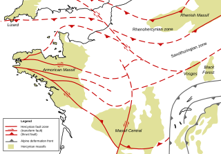
The Armorican Massif is a geologic massif that covers a large area in the northwest of France, including Brittany, the western part of Normandy and the Pays de la Loire. It is important because it is connected to Dover on the British side of the English Channel and there has been tilting back and forth that has controlled the geography on both sides.

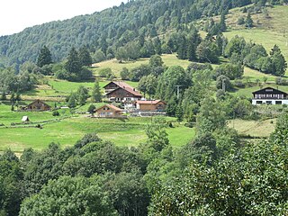
Les Diablerets is a village and ski resort located in the municipality of Ormont-Dessus in the canton of Vaud, Switzerland. It is surrounded by the Diablerets Massif, its peak is the highest point in western Switzerland.
Maladeta is a mountain in the Pyrenees, close to the highest peak in the range, Aneto. It is located in the Natural Park of Posets-Maladeta in the town of Benasque in Province of Huesca, Aragon, Spain. Its northern slope contains the 91-acre (37 ha) Maladeta Glacier, which is divided into the 15-acre (6 ha) Western Maladeta and the 77-acre (31 ha) Eastern Maladeta.

Anseris Mons is an isolated massif (mountain) in the southern highlands of Mars, located at the northeastern edge of Hellas Planitia at longitude 86.65°E and latitude 29.81°S. The mountain is 58 km (36 mi) in diameter and rises to an elevation of approximately 4,200 m (13,780 ft) above datum or about 6,200 m (20,300 ft) above the surrounding plains. The mountain lies in the southeastern quarter of the Iapygia quadrangle (MC-21), straddling the boundary with the adjoining Hellas quadrangle (MC-28) to the south.

The Miage Glacier is a debris-covered glacier in the upper Aosta Valley, in northwestern Italy.
Kunturiri is a mountain in the Cordillera Real of Bolivia, about 5,648 metres (18,530 ft) high. It is also the name of the whole massif. Kunturiri is located in the La Paz Department, Los Andes Province, Pukarani Municipality, southeast of Chachakumani and northwest of Huayna Potosí.

Satyarup Siddhanta is a Bangalore-based Indian mountaineer. On December 15, 2017 he summited Vinson Massif, becoming only the fifth Indian civilian to complete the seven summits. He is the first civilian to accomplish this feat from Karnataka and West Bengal. He is also the 2nd Indian to climb the highest Volcano of the world, Mt. Ojos Del Salado. Satyarup, a certified mountaineer from Himalayan Mountaineering Institute, Darjeeling., has skied the last degree to South Pole, a distance of 111 km. Satyarup is a Techie, Motivational Speaker and an Environmentalist. He is the President and founder of ABETO – "A better tomorrow" foundation, and works as a consultant at Brady Corporation, India.