
The Alpine region of Switzerland, conventionally referred to as the Swiss Alps, represents a major natural feature of the country and is, along with the Swiss Plateau and the Swiss portion of the Jura Mountains, one of its three main physiographic regions. The Swiss Alps extend over both the Western Alps and the Eastern Alps, encompassing an area sometimes called Central Alps. While the northern ranges from the Bernese Alps to the Appenzell Alps are entirely in Switzerland, the southern ranges from the Mont Blanc massif to the Bernina massif are shared with other countries such as France, Italy, Austria and Liechtenstein.

The Last Glacial Period (LGP) occurred from the end of the Eemian to the end of the Younger Dryas, encompassing the period c. 115,000 – c. 11,700 years ago. This most recent glacial period is part of a larger pattern of glacial and interglacial periods known as the Quaternary glaciation extending from c. 2,588,000 years ago to present. The definition of the Quaternary as beginning 2.58 Ma is based on the formation of the Arctic ice cap. The Antarctic ice sheet began to form earlier, at about 34 Ma, in the mid-Cenozoic. The term Late Cenozoic Ice Age is used to include this early phase.
In geomorphology, an outburst flood — a type of megaflood — is a high-magnitude, low-frequency catastrophic flood involving the sudden release of a large quantity of water. During the last deglaciation, numerous glacial lake outburst floods were caused by the collapse of either ice sheets or glaciers that formed the dams of proglacial lakes. Examples of older outburst floods are known from the geological past of the Earth and inferred from geomorphological evidence on Mars. Landslides, lahars, and volcanic dams can also block rivers and create lakes, which trigger such floods when the rock or earthen barrier collapses or is eroded. Lakes also form behind glacial moraines, which can collapse and create outburst floods.

Rila is the highest mountain range of Bulgaria and the Balkan Peninsula. It is situated in southwestern Bulgaria and forms part of the Rila–Rhodope Massif. The highest summit is Musala at an altitude of 2,925 m which makes Rila the sixth highest mountain range in Europe after the Caucasus, the Alps, Sierra Nevada, the Pyrenees and Mount Etna, and the highest one between the Alps and the Caucasus. It spans a territory of 2,629 km2 with an average altitude of 1487 m. The mountain is believed to have been named after the river of the same name, which comes from the Old Bulgarian verb "рыти" meaning "to grub".

A glacial erratic is a piece of rock that differs from the size and type of rock native to the area in which it rests. "Erratics" take their name from the Latin word errare, and are carried by glacial ice, often over distances of hundreds of kilometres. Erratics can range in size from pebbles to large boulders such as Big Rock in Alberta.
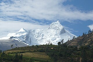
The Cordillera Blanca is a mountain range in Peru that is part of the larger Andes range and extends for 200 kilometres (124 mi) between 8°08' and 9°58'S and 77°00' and 77°52'W, in a northwesterly direction. It includes several peaks over 6,000 metres (19,690 ft) high and 722 individual glaciers. The highest mountain in Peru, Huascarán, at 6,768 metres (22,205 ft) high, is located there.
A glacial lake is a body of water with origins from glacier activity. They are formed when a glacier erodes the land, and then melts, filling the depression created by the glacier.
The Țarcu Mountains are a mountain range in the southwestern Romania, at the western edge of the Southern Carpathians. They are located between the Bistra Valley, Timiș River, Godeanu Mountains and Râul Mare Valley, the last one being a natural barrier between them and the Retezat Mountains. The Țarcu Mountains have been declared Natura 2000 protected area since 2007 because they shelter valuable biodiversity and spectacular nature. Together with the Retezat Mountains, the Godeanu Mountains and Cernei Mountains they form the last European Intact Forest Landscape, if we do not take boreal forests into account.
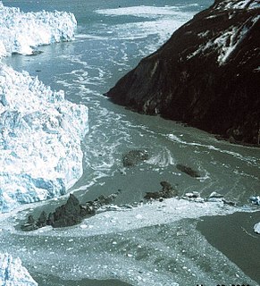
A glacial lake outburst flood (GLOF) is a type of outburst flood that occurs when the dam containing a glacial lake fails. An event similar to a GLOF, where a body of water contained by a glacier melts or overflows the glacier, is called a Jökulhlaup. The dam can consist of glacier ice or a terminal moraine. Failure can happen due to erosion, a buildup of water pressure, an avalanche of rock or heavy snow, an earthquake or cryoseism, volcanic eruptions under the ice, or if a large enough portion of a glacier breaks off and massively displaces the waters in a glacial lake at its base.
Jezerca Peak is the highest peak in the entire Dinaric Alps, the second highest in Albania and the sixth highest in the Balkans, standing at 2,694 m (8,839 ft) above sea level. It is one of the toughest if not one the most dangerous climbs in the Albanian Alps. However, Maja Jezercë is the 28th most prominent mountain peak in the European continent.

The Sierra de Guadarrama is a mountain range forming the main eastern section of the Sistema Central, the system of mountain ranges along the centre of the Iberian Peninsula. It is located between the systems Sierra de Gredos in the province of Ávila, and Sierra de Ayllón in the province of Guadalajara.

Mount Geikie is a mountain in the West Coast Range of Western Tasmania, Australia.

Banyuls-dels-Aspres is a commune in the Pyrénées-Orientales department in southern France.

Mount Pelion East is a mountain located in the Central Highlands region of Tasmania, Australia. The mountain is situated within the Cradle Mountain-Lake St Clair National Park.

Lake Great Falls was a prehistoric proglacial lake which existed in what is now central Montana in the United States between 15,000 BCE and 11,000 BCE. Centered on the modern city of Great Falls, Montana, Glacial Lake Great Falls extended as far north as Cut Bank, Montana, and as far south as Holter Lake. At present-day Great Falls, the Glacial Lake Great Falls reached a depth of 600 feet.

Overdeepening is a characteristic of basins and valleys eroded by glaciers. An overdeepened valley profile is often eroded to depths which are hundreds of metres below the deepest continuous line along a valley or watercourse. This phenomenon is observed under modern day glaciers, in salt-water fjords and fresh-water lakes remaining after glaciers melt, as well as in tunnel valleys which are partially or totally filled with sediment. When the channel produced by a glacier is filled with debris, the subsurface geomorphic structure is found to be erosionally cut into bedrock and subsequently filled by sediments. These overdeepened cuts into bedrock structures can reach a depth of several hundred metres below the valley floor.
Bangda Lake (Tibetan: པང་བཏགས་མཚོ, Wylie: pang btags mtsho ; Chinese: 邦达错; pinyin: Bāngdá Cuò), also Bangdag or Bangdacuo, is a glacial lake in Ngari Prefecture in the northwest of the Tibet Autonomous Region of China. It lies in the western Kunlun Mountains, to the southeast of Guozha Lake. Located at an altitude of 4902 metres, it covers an area of 106 square kilometres with a maximum depth of 21.6 metres and contains 90 glaciers.

Guozha Lake, also Gozha Co, Gozha Tso or Guozhacuo, also known as Lake Lighten, is a glacial lake in Rutog County in the Ngari Prefecture in the northwest of the Tibet Autonomous Region of China. It lies in the western Kunlun Mountains to the northwest of Bangda Lake, not far from the regional border with Xinjiang. Located at an altitude of 5080 metres, it covers an area of 244 square kilometres with a maximum depth of 81.9 metres and his drainage basin contains 62 glaciers.

Sara Sara is a 5,505-metre-high (18,061 ft) volcano lying between Lake Parinacochas and Ocoña River in Peru. It is situated in the Parinacochas Province, Puyusca District, and in the Paucar del Sara Sara Province, in the districts of Pausa and Sara Sara.
The Paleolake Tehuelche is the name for several former lakes that existed in the area of Torres del Paine in southern Patagonia. These were proglacial lakes that existed next to the Patagonian Ice Sheet during the Late Pleistocene and Early Holocene. Some of the evidence of the lakes stem from lake terraces observable at present but these is some uncertainty on which terraces are associated to which lake or lake stage.

