This article needs additional citations for verification .(January 2024) |

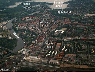
Pichelswerder is a river island located in the Havel River within the Berlin district of Wilhelmstadt, which is part of the Spandau district.
This article needs additional citations for verification .(January 2024) |
Pichelswerder is a river island located in the Havel River within the Berlin district of Wilhelmstadt, which is part of the Spandau district.
Pichelswerder Island is located between Pichelssee (Lake Pichels) and Stößensee (Lake Stößensee), both of which are connected by the Havel River. The island is bordered to the north by Tiefwerder Wiesen, and to the northeast by Kleiner Jürgengraben and Hauptgraben. The interior of the island is a wooded nature reserve, characterized by the presence of old oak and pine trees. The shores of the island are primarily utilized by rowing and sailing clubs. Moreover, Pichelswerder is home to one of the twelve designated dog walking areas in Berlin, situated on both sides of the Heerstraße.

Pichelswerder was discovered in the middle of the 19th century by the people of Spandau and Berlin as a popular excursion destination. Several well-known excursions inns were established on the island, including Wilhelmshöhe, Königgrätzer Garten (now known as Siemenswerder), Wirtshaus zum Freund, and Wirtshaus Rackwitz. The large hall of the Rackwitz Inn later served as a film and television studio after World War II.
In 1879, an erratic boulder was discovered on Pichelswerder in a longitudinal depression running from north to south near the western locales on the Havel River. The local residents dubbed this stone the Wendischer Opferaltar (Wendish sacrificial altar). [1] [2] However, the erratic block on its wall base was lost around 1950.
In 1882, a pontoon bridge was built across the Stößensee, providing access to the restaurants for a "sixer." Furthermore, multiple ferries were in operation to facilitate transportation to and from Pichelswerder. With the construction of the Heerstraße between 1903 and 1911, Pichelswerder was connected to neighboring Pichelsdorf in the west through the Freybrücke (Frey Bridge) and to Charlottenburg in the east via the Stößensee Bridge.
Prior to its incorporation into Greater Berlin in 1920, Pichelswerder was an independent estate district in the district of Osthavelland. According to the 1910 census, the estate district had 39 inhabitants. [3] Although plans were made for a Pichelswerder National Park in the 1910s [4] and a Reichsehrenmal Pichelswerder in the 1920s, [5] both were never realized. Additionally, the buildings for a World's Fair planned by the National Socialists for 1950 on the site were never built.
In some versions of the Schildhorn saga, Pichelswerder is depicted as the starting point of the escape of the Slav prince Jaxa von Köpenick from Albrecht the Bear through the Havel to the Schildhorn in the founding year of the Mark Brandenburg in 1157.

The Havel is a river in northeastern Germany, flowing through the states of Mecklenburg-Vorpommern, Brandenburg, Berlin and Saxony-Anhalt. The 325 kilometres (202 mi) long Havel is a right tributary of the Elbe. However, the direct distance from its source to its mouth is only 94 kilometres (58 mi). For much of its length, the Havel is navigable; it provides an important link in the waterway connections between the east and west of Germany, as well as beyond.

Bundesautobahn 10 is an orbital motorway around the German capital city of Berlin. Colloquially called Berliner Ring , it is predominantly located in the state of Brandenburg, with a short stretch of 5 km in Berlin itself. It should not be confused with the Berliner Stadtring around Berlin's inner city.

Altstadt Spandau is the historic centre of the Spandau borough in the western suburbs of Berlin, situated on the right bank of the Havel river by its confluence with the Spree tributary. It arose near the site of a former Slavic gord during the German eastward expansion (Ostsiedlung) in the early 13th century. A castle at Spandowe, erected on a Havel island to secure the eastern borderlands of the Margraviate of Brandenburg, was already documented in an 1197 deed issued by the Ascanian margrave Otto II.

Kladow is the southernmost district of the Borough of Spandau in Berlin, Germany.

Jungfernheide is an area of forest and heathland located in Berlin in the present-day district of Charlottenburg-Nord, a locality of the borough of Charlottenburg-Wilmersdorf. Formerly a large forested area, it was progressively reduced in size through development and military use. The recently closed Tegel Airport now divides the remainder, with Volkspark Jungfernheide (Jungfernheidepark) to the south, and a larger still-forested region between the airport and Lake Tegel.

Staaken is a locality at the western rim of Berlin within the borough of Spandau.

Westend is a locality of the Berlin borough Charlottenburg-Wilmersdorf in Germany. It emerged in the course of Berlin's 2001 administrative reform on the grounds of the former Charlottenburg borough. Originally a mansion colony, it is today a quite densely settled, still affluent territory adjacent to Berlin's inner city in the east.

Berlin Westkreuz is a station in the Charlottenburg district of Berlin. It is served by the S-Bahn lines S3, S41, S42, S46, S5, S7 and S9 and so represents a major interchange point on the Berlin S-Bahn network. It lies at the opposite end of the Stadtbahn to Ostkreuz and is one of the four main stations on the Ringbahn.

Heerstraße is a railway station in Berlin, Germany. It is located on the Spandau Suburban Line in the Westend district and served by S-Bahn S3 and S9 trains. The station is today listed as a historical monument.

Hakenfelde is a German locality (Ortsteil) of Berlin in the borough (Bezirk) of Spandau.
Wilhelmstadt is a German locality (Ortsteil) of Berlin in the borough (Bezirk) of Spandau.
The Wilhelmstraße in the Berliner district of Spandau is the connecting street between Spandau and Potsdam. In the north, at Seeburger Straße and the Ziegelhof, the Wilhelmstraße runs into the Klosterstraße, about a kilometre south of Spandau Station.

Heerstraße runs from Theodor-Heuss-Platz in Berlin-Charlottenburg to the western city border of Berlin in the locality of Staaken in the borough of Spandau. It is part of Bundesstraße 5; from Theodor-Heuss-Platz to Wilhelmstraße it is forms part of Bundesstraße 2. With a length of around 10 kilometres, it is one of the longest streets in Berlin and an important commuter route. The street is a five-lane expressway (Kraftfahrstraße), depending on traffic flow the middle lane is available during rush hours in the morning (eastbound) and in the evening (westbound).

Geographically, the Havelland is the region around which the River Havel flows in a U-shape between Oranienburg to the northeast and Rhinow to the northwest. The northern boundary of the Havelland is formed by the River Rhin and the Rhin Canal. In the history of Brandenburg, the Havelland represents a historic region.

The Westhafen is Berlin's largest inland port, located in the district of Moabit.

The Tiefwerder Wiesen in Berlin is the remnant of the former floodplain landscape in the Havel/Spreetal lowlands. It is situated in the Tiefwerder area and the lowland region of the Pichelswerder River peninsula in the Wilhelmstadt district of Spandau. These wet meadows contain historical Havel River arms and have been protected under Landschaftsschutzgebiet (LSG) since 1960, covering an area of 66.7 hectares. Within the LSG lies the Faule See, which emerged from an old arm of the Havel.

The Freybrücke is an arch bridge located in the Wilhelmstadt district of the Berlin borough of Spandau. It carries Heerstraße over the Havel and Havelseenweg, connecting Pichelsdorf with the Pichelswerder peninsula. The structure spanning 157.90 meters, serves about 60,000 motorists daily.
Tiefwerder encompasses both a village and a Werder along the Havel River in the Berlin district of Spandau. While the village of Tiefwerder, along with the neighboring southern port of Spandau, falls under the jurisdiction of the district of Spandau, the surrounding forested areas, meadows, and water areas of the Werder are administratively part of the district of Wilhelmstadt.

The Bullengraben is a ditch in Berlin’s glacial valley, which has been in use since the 7th century. It is located in the Berlin district of Spandau and runs from the old village center of Staaken eastwards for about five kilometers to the Havel River, into which it flows north of the Spandau castle rampart. Used for centuries to improve the wetlands, since the 1960s it has been used as a drainage ditch to collect rainwater from the surrounding neighborhoods of Spandau.

The Stößenseebrücke is a steel truss bridge over the Stößensee and the Havelchaussee in the Berlin district of Spandau. The listed bridge from 1908/1909 is part of Heerstraße and connects the Spandau district of Wilhelmstadt with the Westend district of Charlottenburg-Wilmersdorf. The biggest technical and financial problem during the construction of the Heerstraße was bridging the Havel lowland, which includes the Stößensee, an old arm of the Havel. From several options, including an additional 250-meter-long bridge over the Scharfe Lanke, the planners opted for a route that could manage with two bridges - over the Havel and the Stößensee. With regard to the variants of the Stößensee bridge, the "small" solution with a dam embankment and a bridge around 100 meters long was chosen instead of a bridge over the entire lake. The bridge consists of a system of cantilever girders with connected towing girders and has a span of around 50 meters. It was designed by civil engineer Karl Bernhard.