Tiefwerder Wiesen

Last updated
Landscape protection area Tiefwerder-Wiesen
Tiefwerder meadows
Tiefwerder Wiesen 1b.JPG
Boardwalk through the Tiefwerder Wiesen
Berlin relief location map.png
Red pog.svg
Landscape protection area Tiefwerder-Wiesen
Location Berliner Havel-/Spreetalniederung
Coordinates 52°30′55″N13°12′32″E / 52.5152229°N 13.2088575°E / 52.5152229; 13.2088575
Primary inflows Havel
Basin  countries Germany
Max. length1,600 m (5,200 ft)
Max. width900 m (3,000 ft)
Surface area66.7 ha (165 acres)
Max. depth1 m (3 ft 3 in)
Surface elevation300 m (980 ft)
Settlements Berlin-Spandau, Berlin-Charlottenburg

The Tiefwerder Wiesen (lit. German: Tiefwerder meadows) in Berlin is the remnant of the former floodplain landscape in the Havel/Spreetal lowlands. It is situated in the Tiefwerder area and the lowland region of the Pichelswerder River peninsula in the Wilhelmstadt district of Spandau. These wet meadows contain historical Havel River arms and have been protected under Landschaftsschutzgebiet (LSG) (landscape conservation area) since 1960, covering an area of 66.7 hectares. Within the LSG lies the Faule See (Lazy Lake), which emerged from an old arm of the Havel.

Contents

The natural floodplain is the last pike spawning area in Berlin. However, due to the lowering of the Havel water level since 1990, the accessibility of the meadows for the pike has significantly deteriorated. Moreover, the German Unity 17 transport project, if implemented, would cause a further drop in the water level, posing an additional threat to the pike's habitat. Endangered species such as the bladder sedge grow in the wet meadows dominated by sedge in Berlin. The LSG serves as an important inner-city link in the Havel biotope network and functions as a flight path for bats and a migration route for the native beaver. Since 2007, Berlin has been considering extending its protected status to a nature reserve.

Territory boundaries

The highly dissected landscape conservation area lies between the Havel, the Havelchaussee, and the Heerstraße (Bundesstraßen B 2/B 5).

It starts in the north with a narrow east tip of the Freiheitswiesen on Tiefwerder. The western boundary runs southwest between an allotment/weekend settlement and a forest and meadow area, then continues along the Faulen See Lake, and finally crosses the Kleiner Jürgengraben ditch. In the lowland area south of the village of Tiefwerder, the boundary turns west and runs along the Kleiner Jürgengraben for a short distance to the Havel River. Along the river and the Havelseenweg, the western border stretches south almost to the Freybrücke (Frey bridge) and, after a short detour, it reaches the Heerstraße on Pichelswerder.

On the eastern side, the boundary starts from the narrow northern tip of the area, omitting the Tiefwerder waterworks. It runs southward along the Havelchaussee and the Havelaltarm Hohler Weg, which flows into the Stößensee Lake. Here, it also runs parallel to the district border with Charlottenburg-Wilmersdorf, which is marked by the S-Bahn embankment of the Spandauer Vorortbahn (Spandau Suburban Railway), located a few meters away from the Havelchaussee. Just before reaching the Stößensee Lake, the LSG border crosses the Hohlen Weg to the west towards the Steffenhorn and runs below the Schulzenwall and Langer Wall along the Hauptgraben back to the north. Then it circles the weekend settlement on the hill of Pichelswerder at the transverse ditch to the Toten Mantel, turns south again below the hill, and reaches the Heerstraße past the Pichelswerder natural gas storage facility. The southern boundary follows Heerstraße for about 300 meters. The landscape conservation area measures approximately 1.6 kilometers in length from north to south and about 900 meters in width, from west to east.

During the German division, the GDR claimed a small part of the Tiefwerder Wiesen as an exclave of the municipality of Seeburg. However, this claim had no consequences due to the opposition of the British authorities.

Geology, natural space, and climate

Location of the LSG Tiefwerder-Wiesen (borders of the LSG dashed in green) in the Spree - Havel lowlands Karte von Tiefwerder in Berlin.png
Location of the LSG Tiefwerder-Wiesen (borders of the LSG dashed in green) in the Spree - Havel lowlands

The Tiefwerder Wiesen is located in the southern part of the Spree where it meets the Havel River. This region is part of the Weichselian glacial valley in Berlin, characterized by thick sands that reach depths of over 20 meters. The Havel River follows a glacial channel in this area and does not extensively utilize the glacial valley.

On the eastern side, separated by the Havelchaussee and the S-Bahn embankment, lies the Schanzenwald forest, which also belongs to the valley sand area of the Spree lowlands. The Schanzenwald merges into the Murellenberge mountains, creating the Murellenschlucht canyon and Schanzenwald forest nature reserve. These hilly areas are part of the northwestern edge of the Teltow Plateau. Interestingly, the Tiefwerder Wiesen and the Schanzenwald forest run parallel to each other, separated by only a few meters, but are now divided by the S-Bahn embankment of the Spandauer Vorortbahn, also known as Olympic Railway. This railroad was built during preparations for the Summer Olympics, which were canceled due to the First World War, and eventually took place in Berlin 20 years later.

To the west of the Havel channel lies the former lowland Börnicker Lake, also known as Birnicker Lake. On its marshy meadows, the Spandauer Südpark (Spandau South Park) was established in 1923, featuring the Südparksee Lake. The channel continues to flow towards Scharfen Lanke and Grimnitzsee, which are located on the opposite side of the Havel, facing the Tiefwerder Wiesen. South of the Heerstrasse, the LSG Tiefwerder-Wiesen is followed by the landscape conservation area Pichelswerder, after which the Havel, which is canalized at Tiefwerder, opens into the southern Berlin Havel Lake chain. The Tiefwerder meadows are assigned to the Brandenburg-Potsdam Havel area (No. 812) in the natural space unit D 12a (East German Lowlands, Central Brandenburg Plates and Lowlands). [1] [2]

The Tiefwerder Wiesen is in a temperate climate zone, transitioning from the Atlantic-influenced climate of Northern/Western Europe to the continental climate of Eastern Europe, which is similar to the outskirts of Berlin.

Anthropogenic influences on flood dynamics

Tiefwerder on a map from 1842 (detail). The Elsgraben from the Spree to the Faulen See has already been mapped. Karte Tiefwerder 1842.JPG
Tiefwerder on a map from 1842 (detail). The Elsgraben from the Spree to the Faulen See has already been mapped.

The biotope and landscape function of the Tiefwerder Wiesen also referred to as pike spawning meadows, relies heavily on their flood dynamics, which are greatly influenced by the water level of the Havel River and human activities. The Havel lakes play a significant role in regulating the water levels, resulting in a relatively stable environment. The river’s low gradient averaging about 0.05% (equivalent to 5 cm per kilometer), ensures a serene and tranquil flow through the country. [3]

Middle ages

Archaeological discoveries of vessel fragments, belonging to the Prague type and dating back to the sixth to the eighth century, provide evidence of an early Slavic settlement on the eastern shore of the Faulen See (Lazy Lake), which was known as Wirchen Lake until the 19th century. The Middle Ages saw the presence of a Slavic settlement, although it did not significantly impact the water regime of the region. However, many of the Havel's old water names and the former lake name, likely derived from the settlement's name (Wirchen from Slavic verch/virch = height, elevation - referring to the neighboring Teltow slopes), trace back to this historical period. [4]

Following German settlement, the water level of the Havel experienced a significant rise around 1180, attributed to a backwater in Spandau. This increase was primarily caused by the mill dam of the city of Brandenburg, which played a role in altering the flooding dynamics of the area. Despite water regulations implemented during the pre-industrial period between 1500 and 1750, the water balance of the region remained largely unaffected. [5]

Havel regulations, and Elsgraben

Until the mid-19th century, the vast and intricate network of estuary branches from the Spree and numerous ramifications of the Havel would regularly flood the lowlands between the Spree and Pichelswerder. [6] In 1880 and 1881, the canalization of the Havel, known for its strong meandering at Tiefwerder, and the river regulation during the expansion of the southern harbor at Tiefwerder in 1908 significantly altered the water network. [7] However, the Elsgraben, built in 1832, played a crucial role in maintaining good flood dynamics. This canal diverted floodwaters from the Spree directly into the Tiefwerder Wiesen. Originally navigable until 1886, the Elsgraben gradually filled in around 1930. It connected the (old) Spree opposite the former Otternbucht (approximately at the location of today's Reuter combined heat and power plant) with the Faulen See. The primary purpose of the ditch was to protect Spandau by directing water away from the city through the Faulen See into the Havel in case of floods. [8] Additionally, the Elsgraben facilitated the drainage of the Verlandungsmoor Fließwiese Ruhleben (Flow meadow Ruhleben), a former dead ice channel and the northern continuation of the dry valley Murellenschlucht canyon, into the Tiefwerder Wiesen.

Settlement construction and conflicts of interest

Meadows partially wet after heavy rainfall in November 2010 Tiefwerder Wiesen V3.JPG
Meadows partially wet after heavy rainfall in November 2010

In the early 20th century, the floodplain area underwent significant changes due to settlement construction and industrial development. Embankments were built, narrowing the floodplain over time. In 1816, the fishing village of Tiefwerder was established in a higher and flood-free area, marking the first steps of human settlement in the region. As industrial facilities sprouted in the northern part of the area from 1910 onwards, further changes to the landscape were set in motion. The construction of the Heerstraße, between 1910 and 1912, further divided the Stößensee with an embankment, affecting the nearby Pichelswerder as well. The demand for drinking water from the Tiefwerder waterworks prompted the lowering of the groundwater level, starting in 1914. This change allowed for the construction of allotment colonies and weekend houses to the south of the village and along certain ditches. The freedom meadows (Freiheitswiesen) to the north were filled with rubble after the Second World War.

Today, the remaining floodplain in the Tiefwerder-Wiesen landscape conservation area consists only of a limited lowland area south of the village. To protect the delicate wet meadows, the state of Berlin undertook measures in the 1980s, removing road embankments and filled-in paths. Some of the pathways were replaced with footbridges and bridges, promoting a more sustainable approach to the preservation of the area's natural beauty. [6] In 2005, the Naturschutzamt Spandau (Spandau Nature Conservation Office) issued notices of termination to 67 tenants who had allotment garden plots on state-owned land within the LSG. Though many plots have been cleared and their arbors dismantled, legal disputes arose, with some allotment gardeners successfully contesting the termination in court. [9] Presently, certain residents are voicing opposition to the electric fences erected for the commercial keeping of water buffalo, goats, and sheep. These fences encompass several former recreational areas, and allotment gardeners have been granted the right to use them. [10]

Transport project German Unity 17

Havel, southern port of Spandau Sudhafen Spandau 4.JPG
Havel, southern port of Spandau

Various factors such as the reduction of the Spree inflows in Lusatia (the water volume that the Spree fed to the Havel was more than twice as high as that of the Havel itself at its mouth until 1990, 38 m³/s compared to 15 m³/s) or the deepening of the Havel led to a lowering of the Havel water level since 1990. Additionally, the deteriorating flood dynamics have resulted in limited accessibility of the small remaining area for pike, making it possible only during specific years. [6] For instance, prior to 1990, the water level of 29.55 meters above sea level was undercut on 220 days per year, whereas in the 2000s, it reached about 310 days per year. Meanwhile, the water level in the Havel has been reduced to a minimum. [11]

Weekend settlement at the connecting ditch Dead Mantle - main ditch Tiefwerder Wiesen 10.JPG
Weekend settlement at the connecting ditch Dead Mantle – main ditch

The transport project "German Unity" 17 (VDE No. 17) has posed a major threat to the flood dynamics of the Tiefwerder Wiesen. This project involves the expansion of waterways to accommodate barges up to 2000 tons, with an unloading depth of up to 2.8 meters to access the western harbor. The federal waterway link Rühen - Magdeburg - Berlin - which is highly controversial for ecological reasons, includes expanding the Lower Havel Waterway, the Elbe-Havel Canal, and the straightening of a section of the Spree River. The entire stretch was to be dredged to a depth of four meters and, depending on the bank profile, to a water level width of 42–55 meters (up to 72 meters in curves).

Estuary of the Spree into the Havel, on the right the Schuttmuhle Berlin Spreemuendung.jpg
Estuary of the Spree into the Havel, on the right the Schüttmühle Berlin

According to an interim report from the Berlin House of Representatives in February 2009, the transport project could lead to a drop in water levels, resulting in changes to the flooding dynamics of the Tiefwerder Wiesen. It is predicted that water levels might decrease by 1 to a maximum of 13 cm, depending on the discharge situation of low, medium, or high water. [12] As a result, the meadows might no longer experience the same natural flooding patterns they currently do. Despite facing opposition and objections, there are plans to proceed with the project. [13] [14] In response, the state of Berlin aims to protect the Tiefwerder Wiesen by implementing compensatory measures, including artificial irrigation using water from the Havel and the construction of fish ladders. The Federal Waterways and Shipping Administration planned to do this: [11]

"In the course of intervention management for VDE 17, WNA B is therefore now planning, in close coordination with the responsible district and senate administrations, the construction and operation of two small siphon facilities, which in the future will be used to simulate the water level dynamics on the pike spawning meadows that were recorded before 1990. When water levels are high, water should then be transferred from the Havel to the lower-lying Tiefwerder meadows. In order to keep the water in the wetland for as long as possible, a near-natural bottom ramp should be created in the drainage area towards the Jürgengraben, which can also be passed by fish. In this way, the valuable wetland will be sustainably protected against the effects from the VDE 17, but also from the use-related and climatic changes in the Havel catchment area."

VDE 17 – A chance for the Tiefwerder meadows, June 2008

Flora and fauna

Lake at the confluence of the Grosser Jurgengraben, Faulem See, Hauptgraben and Kleiner Jurgengraben Tiefwerder 7b.JPG
Lake at the confluence of the Großer Jürgengraben, Faulem See, Hauptgraben and Kleiner Jürgengraben

The description of the species-rich flora and fauna of the Tiefwerder Wiesen refers to the population of the 2000s.

Plants and plant communities

Sedge reeds and reeds

Dog rosebush at the edge of the meadow Tiefwerder Wiesen 8c.JPG
Dog rosebush at the edge of the meadow

The flooded tall sedge meadows that long dominated the Tiefwerder Wiesen are declining due to increasingly infrequent flooding. However, the riparian sedge, growing up to two meters tall, can still be found along the water bodies' edges. Instead, the wet meadow areas and fallows are now characterized by slender sedge meadows from the sedge genus. The main plant in this community is the slender sedge, a perennial, herbaceous plant that can reach heights between 30 and 150 cm. In the siltation areas, it is joined by the bladder sedge, which is endangered in Berlin [15] and occasionally forms a hybrid with the slender sedge. The slender sedge reed has a long survival capacity with increasing drainage but is displaced by reed canary grass in areas of better-aerated soils. Extensive water swath reeds, also known as giant swaths or sweetgrass, dominate the wetter parts of the meadow, often forming pure stands. These sweetgrass plants can grow up to two meters high. From May to July, the cuckoo campion adds pink flowers and stands up to 60 cm tall in the sedge and reed-rich areas of the meadow. Pennywort and yellow-flowered marsh marigolds also bloom in this period, while the marsh marigold might also have a weaker second flowering phase between July and October. Later in the season, the meadow rue with yellow buttercups (June to August) and poison buttercups, especially in June, contribute to the yellow flowering display. From July to September, the dark purple flowers of the marsh thistle add contrast to the yellow blooms. [6] [16] In early summer, wild rose shrubs like the dog rose showcase many light pink flowers along the paths and shrubbery edges.

Reed belt and floodplain forest relics

Boardwalk through reeds Tiefwerder Wiesen 5.JPG
Boardwalk through reeds
The specially protected water iris in the Tiefwerder meadows Tiefwerder Wiesen 8b.JPG
The specially protected water iris in the Tiefwerder meadows

In the vast reed and cattail belts of the river arms and ditches, one can experience a beautiful array of colors provided by sporadic purple loosestrife, marsh zest, and the water iris, which is classified as species protected under the Bundesartenschutzverordnung (BArtSchV) (Federal Species Protection Ordinance). The delicate hues of violet-red, burgundy, whitish, and yellow color create a picturesque landscape. The open riparian areas and watercourse edges are characterized by willow bushes and floodplain forest relics, including silver willow and fluttering elm. Especially at the Havelaltarm Toter Mantel, which extends to Heerstraße, a softwood floodplain is preserved. In the zones with rich herbaceous flora, plants like the marsh fern (Theylpteris palustris), marsh ragwort, stiff sedge, and common loosestrife, which was formerly administered in folk medicine for scurvy, diarrhea, and fever. Originally from the Himalayas, the balsam is spreading strongly on wet, nutrient-rich meadows, forming dense stands of dominance. The fast-growing and rapidly multiplying neophyte was first imported to England from Kashmir in 1839, from where it reached the European continent as an ornamental plant. It belongs to the heterosporous plants, which were deliberately introduced ethelochor. Similar to other water lily plants, the yellow pond lily, which is protected in Germany, covers large areas of open water with floating foliage. Rich yellow, hermaphroditic flowers 4 to 12 cm in diameter protrude from its sea of green leaves. [6] [16]

Animals

The Tiefwerder-Wiesen biotope provides a diverse habitat for fish, amphibians, reptiles, insects, birds, and mammals such as bats and the beaver, which has now become a permanent resident after several guest visits.

Fishes

Spined loach Cobitis taenia.jpg
Spined loach

The significance of the Tiefwerder Wiesen as a pike spawning ground lies in the oviposition of the predatory fish. From March to May, the substrate spawner seeks out flooded floodplain meadows or shallow shore areas of standing waters. Here, the pike carefully attaches its eggs to water plants, roots, or branches. While the second traditional Berlin pike spawning meadow at Parschenkessel on Pfaueninsel became inaccessible to the pike years ago, the fish have also been unable to reach Tiefwerder Wiesen since 1990. "With water depths of less than 5 centimeters, it is only possible for juvenile fish to swim through the connection from the main ditch. However, in wetter years, some old fish can manage to do this, ensuring successful spawning in the Tiefwerder Wiesen." [6]

Measuring up to 1.5 meters long, the pike preys on whitefish species such as roach, white bream, and rudd, which are known for peacefully coexisting and spawning in abundance in the ditches and river oxbow lakes, just like river perch. Similarly, the protected turbot, under Annex II of the Fauna-Flora-Habitat (FFH) (Habitats Directive), searches for food only at night and burrows into the bottom during the day, with only its head and tail protruding. Another species of concern, the asp, a member of the carp family, gather in small schools as juveniles but develops into solitary fish as adults. For this fish, survival relies on the accessibility and patency of waterways. [17]

Mammals

The otter, occasionally spotted in the Tiefwerder Wiesen, finds its ideal habitat in the shallow, fish-rich Havelaltarms and the flood plains. This aquatic marten species is listed as threatened on the Berlin Red List of Endangered Species (as of 2003) and is strictly protected under the Bundesartenschutzverordnung (BArtSchV) (Federal Ordinance on the Protection of Species). Despite special surveys and conversation efforts by the state of Berlin to safeguard its population, uncertainties persist about the otter's ability to establish a stable presence in Berlin. Their habitats are constrained by bank construction, water pollution, recreational pressure, and potential losses from traffic and fish traps. [18] Similarly, the beaver also holds the same protection status and has been native to the Upper Havel and Lake Tegel since 1994 as a "true new citizen" with several beaver burrows. [18] From Lake Tegel, the rodent visited the Tiefwerder Wiesen down the Havel several times as a guest. In the meantime (as of 2008), beavers are said to have settled permanently in Tiefwerder. [6]

The Tiefwerder Wiesen serves as a nurturing ground for various wildlife, including foxes and badgers. [6] However, the abundant presence of wild boars has become a concern, with the Senate Department for Urban Development citing their burrowing activity as a contributing factor to the decline of the tall sedge meadows. For the planned designation of the landscape conservation area as a nature reserve, the state of Berlin conducted investigations on the bat fauna in the Tiefwerder Wiesen and Pichelswerder in 2007. [19] Bats such as the greater mouse-eared bat (strictly protected according to the BArtSchV and listed in Annex II of the Fauna-Flora-Habitat-Richtlinie (FFH) (Habitats Directive); downgraded in Berlin 2003 from endangered to critically endangered) and the water bat (upgraded in Berlin 2003 from endangered to critically endangered) [20] frequently use the Havel channel as a flight path and hunting ground. These nocturnal and highly social bats seek out the insect-rich Tiefwerder Wiesen for hunting, starting from their roosts in places like the Citadel or the old walls on Pfaueninsel.

Insects

Adult common frog female. Due to a positive population development, the frog is no longer considered endangered in Berlin . Rana temporaria LC0030.jpg
Adult common frog female. Due to a positive population development, the frog is no longer considered endangered in Berlin .

Among the insects, the presence of the black cobwater beetle (Hydrophilus aterrimus) in the Tiefwerder is noteworthy, as it is highly endangered in Berlin. This heat-loving water beetle, strictly protected under the Bundesartenschutzverordnung (BNatSchG), strongly resembles the large water beetle, and prefers larger, mostly perennial waters in sunny areas. [21] Although many waters are suitable for adult large beetles (length up to five centimeters), they are not suitable for their larvae. Especially the 1st and 2nd larval stages require extremely shallow, vegetated, and undisturbed shallow water areas. The young larvae, supported by plant growth, lift their food (small aquatic snails) out of the water to predigest it outside their body. [22]

Several weevil species were last recorded in the Tiefwerder Wiesen in the 1980s and early 1990s. Since intensive searches did not yield any further findings, the small beetles (1.3–20 mm) are mostly considered lost in Berlin. Among them are the shore weevil (Ceutorhynchus scapularis; last record August 1985, one specimen), the hollow-toothed weevil (Datonychus angulosus; May 1990, four specimens), the suture-striped catkin weevil (Dorytomus hirtipennis; February 1991, fifteen specimens found in the bark scales of a silver willow), and the broad silky weevil (Smicronyx smreczynskii; June 1989, one specimen). The silt weevil (Pelenomus velaris), which prefers vegetation-free, periodically flooded, waterlogged sand and mud areas, and its developing plant is not known. It was recorded in Berlin for the first and last time in May 1990 with one specimen. In December 2003, a specimen of the brown-red willow weevil (Ellescus infirmus) was found for the first time on the sieve (soil sample) of a willow in the Tiefwerder Wiesen. [18] [23]

Other animals

The Critically Endangered Kingfisher, twice Bird of the Year Smallblue.jpg
The Critically Endangered Kingfisher, twice Bird of the Year

The reedbeds of the Tiefwerder Wiesen are home to the grass frog, which is specially protected under the BNatSchG, but since a good population trend was noted as early as 1991, it is no longer classified as endangered on the current Berlin Red List of 2003. The grass snake, however, remains endangered in Berlin. It also finds its preferred habitat in the area: structurally rich wetlands, both aquatic and terrestrial. [16] [24]

Grey herons are a common sight as they linger in the meadows before their autumn migration south to feed. The Tiefwerder Wiesen also serves rare and endangered bird species as breeding, migratory, and wintering grounds. For example, the kingfisher, which is highly endangered in Berlin, can occasionally be seen. Due to its endangerment, this species, which is strictly protected under the BNatSchG, has already been voted Bird of the Year twice in Germany, in 1973 and 2009. The sedge meadows, reeds, and tall grasses are home to pond warbler, marsh warbler, dunnock, coot, and little grebe, among others. [16] The bird of the year 1983, the sand martin, is also found in the Tiefwerder Wiesen. Its young birds congregate in large numbers on roosts in the reeds and willow thickets after leaving the breeding burrows.

Nature conservation and trails

Protected areas and maintenance measures

Toter Mantel Tiefwerder Wiesen 9.JPG
Toter Mantel

With the Ordinance for the Protection of Landscape Parts in the District of Spandau of Berlin, the Tieferwerder Wiesen has been designated as a Landschaftsschutz or LSG (protected landscape area). [18] Today, it is listed as No.24 and it covers an area of 66.69 ha. [25] Since 2007, the state has been considering raising its protection status as a nature reserve. [6] Due to its proximity to the Tiefwerder waterworks, which supply drinking water to six Berlin districts, significant portions of the LSG are part of the narrower water protection zone II. [26]

The Senate Department of Urban Development and Environmental Protection stated the target in the 1994 Landscape Program and Species Conservation Program: [27]

"The still preserved, natural landscape elements of these lowland areas are to be protected and extended. The Ruhleben flowing meadow, the Tiefwerder meadows and the Schönower meadows are to be maintained as extensive wet meadows. Along the watercourses, continuous green and open spaces are to be created as connecting elements and planted according to their location (wet meadows and woody plants of the alder marsh, floodplain and oak-hornbeam forests).

Landscape Program and Species Protection Program 1994, Berlin

The main focus of preservation and protection measures within the landscape conservation area is to maintain flood dynamics. This may involve artificial irrigation of the Tiefwerder Wiesen with Havel water and the construction of fish ladders if necessary. Another priority is preserving the softwood meadows, especially for the beaver population after removing dams, roads, arbors, and bank obstructions. Since 2014, regular maintenance mowing has stopped, and instead, a conservation approach using Asian water buffalo, sheep, and goats has been adopted to manage the meadows and conserve the ecosystem. These animals are protected and kept effective by enclosing the meadows with electric fences, preventing access by residents and visitors. Additionally, forestry measures are planned to develop the adjacent Pichelswerder forest into a near-natural mixed oak forest.

Road network and connection to Berlin's green corridors

Boardwalk Tiefwerder Wiesen 2a.JPG
Boardwalk

A circular trail provides access to the central wetland. A plank footbridge about 200 meters long, built in 1996, leads through the wet meadows, while wooden bridges guide over several ditches and the Totes Mantel. An additional long footbridge over the Kleiner Jürgengraben connects the meadows with the Dorfstraße in Tiefwerder and two footpaths with the Heerstraße.

Towards the south, the area is linked to the Havel Heights Trail via Pichelswerder and the Grunewald, while to the east, it connects to the natural area of the Murellenberge and the Ruhleben flowing meadow at the Teltownord edge. In 2004, the Senate Department for Urban Development proposed an elevated path on the edge of the Teltownord as part of a plan for the western region of Berlin. This path would create an almost continuous green corridor, starting from the Tiefwerder Wiesen, passing via Charlottenburg Palace and the Großer Tiergarten to the western part of the city. In 2007, DB ProjektBau also completed the Bullengraben Green Corridor as a nature conservation compensation measure for the adverse effects on nature and the landscape caused by the construction project for the high-speed rail line between Hanover and Berlin. The Bullengraben green corridor runs about 4.5 kilometers west of Staaken along the Havel River. To further enhance the green corridor and connect it to Tiefwerder and the Tiefwerdre Wiesen, the Senate administration proposed the construction of a pedestrian footbridge across the river, as the Bullengraben green corridor meets the Havel only about one kilometer north of the village of Tiefwerder. [28] [29]

The Tiefwerder meadows in the Havel biotope network

View of the Havel and the Tiefwerder meadows from the Frey Bridge (right) Tiefwerder Wiesen 12.JPG
View of the Havel and the Tiefwerder meadows from the Frey Bridge (right)

The biotope network is recognized for its vital role in linking habitats for the conservation of endangered species and has been anchored as a new conservation goal in the Naturschutzgesetz or NSG (Nature Conservation Act). The Havel River and its continuity are of immense importance for migrating fish, as a flight path for bats, as a breeding, migration, and wintering area for birds, and as a migration route for beavers and otters. Recognizing its significance, Berlin's nature conservation associations included the Havel as a connecting landscape element in their list of proposals for the re-registration of protected areas under Article 10 of the European Fauna-Flora-Habitat Directive (FFH) for the state of Berlin in 2000. In Berlin alone, the Havel River links ten landscape protection areas and three nature conservation areas, including the Imchen Island near Kladow NSG, the Pfaueninsel NSG, and the Spandauer Forst LSG. Along its course, it connects existing FFH areas such as the Uckermärkische Seenlandschaft or the Tegeler Fließ, as well as designated SPA areas like the Havelländisches Luch or the lowlands of the lower Havel. [2] Together with the adjacent luch landscapes such as Rhinluch, Havelländisches Luch, Dossebruch and Jäglitzniederung, the lower Havel lowlands form the largest contiguous inland wetland in western-Central Europe. Within this extensive biotope network, the centrally located Tiefwerder Wiesen plays a crucial role as an inner-city link and acts as a " stepping stone for crossing the urban area" for many species. [6]

See also

Related Research Articles

<span class="mw-page-title-main">Havel</span> River in Germany

The Havel is a river in northeastern Germany, flowing through the states of Mecklenburg-Vorpommern, Brandenburg, Berlin and Saxony-Anhalt. The 325 kilometres (202 mi) long Havel is a right tributary of the Elbe. However, the direct distance from its source to its mouth is only 94 kilometres (58 mi). For much of its length, the Havel is navigable; it provides an important link in the waterway connections between the east and west of Germany, as well as beyond.

<span class="mw-page-title-main">Spree (river)</span> River in Germany and the Czech Republic

The Spree is, with a length of approximately 400 kilometres (250 mi), the main tributary of the River Havel. The Spree is much longer than the Havel, which it flows into at Berlin-Spandau; the Havel then flows into the Elbe at Havelberg. The river rises in the Lusatian Highlands, that are part of the Sudetes, in the Lusatian part of Saxony, where it has three sources: the historical one called Spreeborn in the village of Spreedorf, the water-richest one in Neugersdorf, and the highest elevated one in Eibau. The Spree then flows northwards through Upper and Lower Lusatia, where it crosses the border between Saxony and Brandenburg. After passing through Cottbus, it forms the Spree Forest, a large inland delta and biosphere reserve. It then flows through Lake Schwielochsee before entering Berlin, as Müggelspree(pronounced[ˈmʏɡl̩ˌʃpʁeː] ).

<span class="mw-page-title-main">Tonlé Sap</span> Combined lake and river system in Cambodia

Tonlé Sap (; Khmer: ទន្លេសាប, Tônlé Sab ; lit.'Fresh River' or commonly translated as 'Great Lake' is a lake in the northwest of Cambodia. Belonging to the Mekong River system, Tonlé Sap is the largest freshwater lake in Southeast Asia and one of the most diverse and productive ecosystems in the world. It has been designated as a Biosphere Reserve by UNESCO in 1997 due to its high biodiversity. In the 21st century, the lake and its surrounding ecosystems are under increasing pressure from deforestation, infrastructure development and climate change.

<span class="mw-page-title-main">Danube-Auen National Park</span>

Donau-Auen National Park covers 93 square kilometres in Vienna and Lower Austria and is one of the largest remaining floodplains of the Danube in Middle Europe.

<span class="mw-page-title-main">Westend (Berlin)</span> Quarter of Berlin in Germany

Westend is a locality of the Berlin borough Charlottenburg-Wilmersdorf in Germany. It emerged in the course of Berlin's 2001 administrative reform on the grounds of the former Charlottenburg borough. Originally a mansion colony, it is today a quite densely settled, still affluent territory adjacent to Berlin's inner city in the east.

<span class="mw-page-title-main">Gornje Podunavlje</span> Protected wetland area in the northwest of Serbia

Gornje Podunavlje Special Nature Reserve is a large protected area of wetland in the northwest of Serbia, on the Danube's left bank. It comprises two large marshes, Monoštorski Rit and Apatinski Rit and vast forests, meadows, ponds, swamps and the Danube's meanders, including 66 km (41 mi) of the Danube course. It is a part of the trans-boundary biosphere reserve "Mura-Drava-Danube", a five country project, dubbed the "Amazon of Europe".

<span class="mw-page-title-main">Wilhelmstadt</span> Quarter of Berlin in Germany

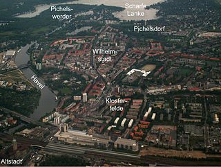
Wilhelmstadt is a German locality (Ortsteil) of Berlin in the borough (Bezirk) of Spandau.

<span class="mw-page-title-main">Berlin–Lehrte railway</span> Major east-west train infrastructure in Germany

The Berlin–Lehrte railway, known in German as the Lehrter Bahn, is an east–west line running from Berlin via Lehrte to Hanover. Its period as a separate railway extended from its opening in 1871 to the nationalisation of its owner, the Magdeburg-Halberstadt Railway Company on 1 July 1886. The company's Berlin station, the Lehrter Bahnhof was finally torn down in 1958.

<span class="mw-page-title-main">Havelland Luch</span>

The Havelland Luch is a lowland area inside a bend of the River Havel west of Berlin, and forms the heart of the Havelland region.

<span class="mw-page-title-main">Havelland</span> Region in Brandenburg, Germany

Geographically, the Havelland is the region around which the River Havel flows in a U-shape between Oranienburg to the northeast and Rhinow to the northwest. The northern boundary of the Havelland is formed by the River Rhin and the Rhin Canal. In the history of Brandenburg, the Havelland represents a historic region.

<span class="mw-page-title-main">Lake Beloye (Ryazan Oblast)</span>

Lake Beloye is a lake in Klepikovsky District, Ryazan Oblast, Russia. It is notable for its relatively great depth for the region - 50 metres (160 ft) - created as a deep gouge in the landscape in the most recent glaciation. The lake is located in the Meshchyera Lowlands, a glacial alluvial plain of swampy lowlands, gravelly moraines and limestone bedrock. It was once connected by an artificial canal to Lake Velikoye. The canal was filled in 2009. Lake Beloye is surrounded by pine forests, with reeds and sedge predominating on the shore. It is a popular lake for recreation and fishing, being home to pike, carp and other fish.

<span class="mw-page-title-main">Khingan Nature Reserve</span> Strict nature reserve in Amur Oblast, Russia

Khingan Nature Reserve is a Russian 'zapovednik', located in the extreme south-east of the Amur River region of the Russian Far East. The reserve covers two types of habitat: the flat Arkharinskaya lowlands with abundant wetlands, and forested spurs of the Lesser Khingan mountains. In particular, Khingan Reserve was created to protect steppe and forest-steppe landscapes, and nesting sites of the endangered Red-crowned crane and the vulnerable White-naped crane. The reserve is situated in the Arkharinsky District of Amur Oblast.

<span class="mw-page-title-main">German Reunification Transport Projects</span>

The German Reunification Transport Projects or German Unity Transport Projects, commonly known by their German initials VDE, are a set of major construction projects to increase and improve transport links between Eastern and Western Germany after German reunification. These projects are planned to positively impact regional development and infrastructure in the new federal states and across the inner German border.

<span class="mw-page-title-main">Old Neckar</span> Nature reserve in Baden-Württemberg, Germany

Old Neckar is a nature conservation area designated by decree of the Regional Council Stuttgart on the territory of the municipality Altbach and the town Esslingen in the district of Esslingen in Baden-Württemberg. A 16.0-hectare (40-acre) area had already been placed under protection by decree of December 2, 1985.

<span class="mw-page-title-main">Poodří Protected Landscape Area</span> Protected area in Czech Republic

Poodří Protected Landscape Area is a protected landscape area in the Moravian-Silesian Region of the Czech Republic. It was declared on 1 May 1991.

<span class="mw-page-title-main">Pichelswerder</span> River island of the Havel in Berlins Wilhelmstadt district of the Spandau district

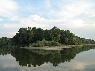
Pichelswerder is a river island located in the Havel River within the Berlin district of Wilhelmstadt, which is part of the Spandau district.

<span class="mw-page-title-main">Freybrücke</span> Road bridge over the Havel in Berlin

The Freybrücke is an arch bridge located in the Wilhelmstadt district of the Berlin borough of Spandau. It carries Heerstraße over the Havel and Havelseenweg, connecting Pichelsdorf with the Pichelswerder peninsula. The structure spanning 157.90 meters, serves about 60,000 motorists daily.

<span class="mw-page-title-main">Tiefwerder</span> Location and Werder of the Havel in the Berlin district of Spandau

Tiefwerder encompasses both a village and a Werder along the Havel River in the Berlin district of Spandau. While the village of Tiefwerder, along with the neighboring southern port of Spandau, falls under the jurisdiction of the district of Spandau, the surrounding forested areas, meadows, and water areas of the Werder are administratively part of the district of Wilhelmstadt.

<span class="mw-page-title-main">Bullengraben</span> Tributary of the Havel

The Bullengraben is a ditch in Berlin’s glacial valley, which has been in use since the 7th century. It is located in the Berlin district of Spandau and runs from the old village center of Staaken eastwards for about five kilometers to the Havel River, into which it flows north of the Spandau castle rampart. Used for centuries to improve the wetlands, since the 1960s it has been used as a drainage ditch to collect rainwater from the surrounding neighborhoods of Spandau.

<span class="mw-page-title-main">Stößensee Bridge</span> A steel truss bridge over the Stößensee lake.

The Stößenseebrücke is a steel truss bridge over the Stößensee and the Havelchaussee in the Berlin district of Spandau. The listed bridge from 1908/1909 is part of Heerstraße and connects the Spandau district of Wilhelmstadt with the Westend district of Charlottenburg-Wilmersdorf. The biggest technical and financial problem during the construction of the Heerstraße was bridging the Havel lowland, which includes the Stößensee, an old arm of the Havel. From several options, including an additional 250-meter-long bridge over the Scharfe Lanke, the planners opted for a route that could manage with two bridges - over the Havel and the Stößensee. With regard to the variants of the Stößensee bridge, the "small" solution with a dam embankment and a bridge around 100 meters long was chosen instead of a bridge over the entire lake. The bridge consists of a system of cantilever girders with connected towing girders and has a span of around 50 meters. It was designed by civil engineer Karl Bernhard.

References

  1. "Liste aller Naturraum-Haupteinheiten in Deutschland, Karte der Haupteinheitengruppen und Großregionen 1./2. Ordnung". geographie.giersbeck.de. Retrieved 2023-07-26.
  2. 1 2 "Liste für die Nachmeldung von Schutzgebieten nach der FFH-Richtlinie für das Land Berlin von den Berliner Naturschutzverbänden" (PDF).
  3. Winfried Schich. Die Havel als Wasserstraße im Mittelalter: Brücken, Dämme, Mühlen, Flutrinnen. Antrittsvorlesung. p. 6.
  4. Winfried Schich. Burg, Stadt und Umland im Mittelalter. In: Wolfgang Ribbe (Hrsg.): Slawenburg, Landesfestung, Industriezentrum. pp. 25, 90.
  5. Winfried Schich. Die Havel als Wasserstraße im Mittelalter: Brücken, Dämme, Mühlen, Flutrinnen. Antrittsvorlesung. pp. 12, 22.
  6. 1 2 3 4 5 6 7 8 9 10 Landschaftsschutzgebiet Tiefwerder Wiesen. In: Senatsverwaltung
  7. Wolfgang Ribbe. Spandau im Zeitalter der Industrialisierung. In: Wolfgang Ribbe (Hrsg.): Slawenburg, Landesfestung, Industriezentrum. p. 242.
  8. kaupertmedia. "Elsgrabenweg 2-30 in Berlin - KAUPERTS". berlin.kauperts.de (in German). Retrieved 2023-07-26.
  9. Eberle, Sebastian (2008-05-24). "Gericht wirft Naturschutzamt Willkür vor". www.morgenpost.de (in German). Retrieved 2023-07-26.
  10. "Home". FreundeKleinVenedigs (in German). Retrieved 2023-07-26.
  11. 1 2 "VDE 17 – Eine Chance für die Tiefwerder Wiesen" (PDF).
  12. "Mitteilung – zur Kenntnisnahme – Stadt- und umweltverträglicher Ausbau von Spree und Havel (neu) (alt: Verkehrsprojekt Deutsche Einheit 17 qualifiziert abschließen – Ausbau von Havel und Spree natur- und stadtverträglich gestalten)" (PDF).
  13. . 2009-05-28 https://web.archive.org/web/20090528050436/http://www.stopp-havelausbau.de/. Archived from the original on 2009-05-28. Retrieved 2023-07-26.{{cite web}}: Missing or empty |title= (help)
  14. "Rot-rote Koalition bringt Antrag zum Flussausbau ein: Mit Laternen und Fackeln gegen den Havelausbau". Berliner Zeitung (in German). 2008-05-22. Retrieved 2023-07-26.
  15. "FloraWeb - Artsteckbrief: Gefährdung & Schutz". www.floraweb.de. Retrieved 2023-07-27.
  16. 1 2 3 4 Informationstafel vor Ort, Naturschutz- und Grünflächenamt Spandau, Stand: 1996
  17. "Pisci Page: Flußkrebse, Neunaugen und Fische Deutschlands - Rapfen (Aspius aspius)". 2009-10-28. Archived from the original on 2009-10-28. Retrieved 2023-07-27.{{cite web}}: CS1 maint: unfit URL (link)
  18. 1 2 3 4 "Senatsverwaltung für Mobilität, Verkehr, Klimaschutz und Umwelt". www.berlin.de (in German). 2023-07-24. Retrieved 2023-07-27.
  19. Susanne Rosenau: Untersuchungen zur Fledermausfauna auf Pichelswerder und in den Tiefwerder-Wiesen in Berlin Spandau (Artenschutzfachbeitrag für die geplante Ausweisung des Gebietes als NSG), Berlin 2007, unveröffentlicht.
  20. "Jürgen Klawitter, Rainer Altenkamp et al.: Rote Liste und Gesamtartenliste der Säugetiere (Mammalia) von Berlin". 10 January 2024. pp. 1, 5, 8, 13.
  21. https://web.archive.org/web/20140102200547/https://www.stadtentwicklung.berlin.de/natur_gruen/naturschutz/downloads/artenschutz/rotelisten/20_wasserkaefer_print.pdf. Archived from the original (PDF) on 2014-01-02. Retrieved 2023-07-27.{{cite web}}: Missing or empty |title= (help)
  22. Lars Hendrich, Michael Balke: Zum Vorkommen der Kolbenwasserkäfer, Hydrophilus aterrimus (Eschscholtz) und Hydrophilus piceus (L.), in Berlin (Coleoptera: Hydrophilidae) – Verbreitung, Habitatbindung, Gefährdung, Schutzmaßnahmen. 1995, Berliner Naturschutzblätter 39 (3), Manuskriptversion für die Berliner Naturschutzblätter. Zum Vorkommen auf den Tiefwerder Wiesen pp. 4, Zitat aus pp. 5.
  23. "Rote Liste und Gesamtartenliste der Amphibien und Reptilien von Berlin". 2 November 2005. pp. 2, 5, 6, 9, 12.
  24. "Rote Liste und Gesamtartenliste der Amphibien und Reptilien von Berlin" (PDF). Archived from the original (PDF) on 2015-09-24.
  25. "FIS-Broker". fbinter.stadt-berlin.de. Retrieved 2023-07-27.
  26. "Verordnung zur Festsetzung des Wasserschutzgebietes für das Wasserwerk Tiefwerder (Wasserschutzgebietsverordnung Tiefwerder)".
  27. "Landschaftsprogramm, Artenschutzprogramm 1994".
  28. Planwerk Westraum Berlin. Ziele, Strategien und landschaftsplanerisches Leitbild (PDF). Kulturbuchverl. 2004. pp. 9, 13, 19, 27, 29. ISBN   3-88961-185-0. Archived from the original (PDF) on 2010-01-07.
  29. "DB Konzern". www.deutschebahn.com (in German). Retrieved 2023-07-27.

Further reading