Related Research Articles

The Aconcagua River is a river in Chile that rises from the conflux of two minor tributary rivers at 1,430 metres (4,690 ft) above sea level in the Andes, Juncal River from the east and Blanco River from the south east. The Aconcagua river flows westward through the broad Aconcagua valley and enters the Pacific Ocean near the city of Concon, 20 kilometres (12 mi) north of Valparaíso.

The Elqui River starts in the west Andes and flows into the Pacific Ocean near the Chilean city of La Serena. It is a wine and pisco producing area. Vicuña, the main town of the middle valley, was the home of Nobel Laureate poet Gabriela Mistral.

Valdivia is a city and commune in southern Chile, administered by the Municipality of Valdivia. The city is named after its founder, Pedro de Valdivia, and is located at the confluence of the Calle-Calle, Valdivia, and Cau-Cau Rivers, approximately 15 km (9 mi) east of the coastal towns of Corral and Niebla. Since October 2007, Valdivia has been the capital of Los Ríos Region and is also the capital of Valdivia Province. The national census of 2017 recorded the commune of Valdivia as having 166,080 inhabitants (Valdivianos), of whom 150,048 were living in the city. The main economic activities of Valdivia include tourism, wood pulp manufacturing, forestry, metallurgy, and beer production. The city is also the home of the Austral University of Chile, founded in 1954 and the Centro de Estudios Científicos.

The Cruces River is a river in south-central Chile. Río Cruces originates from hills near the Villarica volcano and flows then in south-west direction. The southern and final part of the river flows in a south-south-west direction following the eastern flank of Cordillera de Oncol. At the latitude of the city of Valdivia it is crossed by Río Cruces Bridge next to its outflow into Valdivia River.
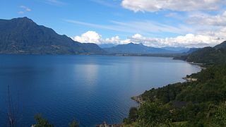
Ranco Lake is located in Ranco Province of Chile. It is the largest lake of Los Ríos Region and the fourth largest in Chile. Administratively Ranco Lake is split into three communes; La Unión, Futrono and Lago Ranco. The lake hosts a series of islands, of which Huapi Island is the largest. Illeifa Island is owned by the affluent Edwards family. The western half of the lake is roughly circular while the eastern part features deep embayments. Geographically the lake lies in the Andean precordillera, the zone between the Chilean Central Valley and the Andes.


Caucau River is minor river in the city of Valdivia, southern Chile. Caucau River acts as a regulating channel between Cruces River and Calle-Calle River forming the Isla Teja island in front of the city centre. It confluence with Calle-Calle River marks the beginning of Valdivia River. '

Calle-Calle River, also called Gudalafquén in Mapuche language, is a river in Valdivia Province, southern Chile. It drains waters from the San Pedro River to the Valdivia River, which in turn flows into Corral Bay on the Pacific Ocean.
Carlos Anwandter Nature Sanctuary is protected wetland in Cruces River about 15 km (9 mi) north of Valdivia, Chile. The sanctuary is named after the German politician Carlos Anwandter who settled in Valdivia in 1850. This sanctuary provides a home for many native waterbird species to flourish, and contains roughly 119 species of birds alone. The most numerous bird species in the sanctuary are the black-necked swans followed by coots.

Cutipay River is a river in Valdivia municipality, southern Chile. Cutipay is often referred to as an inlet of Valdivia River rather than a river. The water flow in Cutapay changes twice a day due to the tide in the Valdivia River. The northern part of the river hosts a small artisan shipyard. Wooden boats constructed in Cutipay can be found from the town of Queule to as far south as Guaitecas Archipelago.
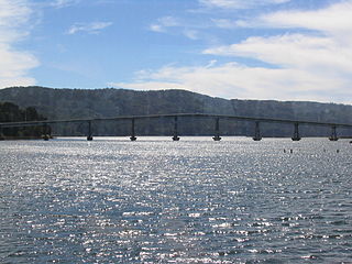
Torobayo is a suburb of Valdivia, Chile. It lies west of Isla Teja and connects to the city through Río Cruces Bridge.

Tornagaleones River is a river and eastuarine channel in Los Ríos Region, Chile. Together with Valdivia and Futa River it encloses the fluvial island of Isla del Rey. The fresh waters of Tornagaleones comes from Futa, Naguilán and Valdivia River. During high tide brackish waters from Corral Bay enters the channel.
The Angachilla River is a river of Chile. The river and the wetland of the same name drains toward Valdivia River to which it connects near San Ramón Peninsula. The southern peripheral neighborhoods of Valdivia reaches the revier.

The Claro River is a river of Chile located in the Maule Region. It rises in the Andes, in the Radal Siete Tazas National Park and flows northwest until the city of Molina. Then, it flows southwest, crosses below the Panamericana, to the vicinity of the city of Talca to empty into the Maule River. In this last portion of its course, the river receives the waters of the tributary Lircay River.

The Estero Limache is a river of Chile. The invasive plant species Limnobium laevigatum is present in the river.
Cabo Blanco is a Chilean hamlet (caserío) located in Valdivia, Valdivia Province, Los Ríos Region.

Limnobium laevigatum is a floating aquatic plant, and is a member of the family Hydrocharitaceae. Common names include West Indian spongeplant, South American spongeplant and Amazon or smooth frogbit. This plant was introduced to North American waterways through use in aquariums and aquascapes.
Las Ánimas, is an industrial and residential neighborhood located on the northern side of Valdivia
The Huilliche uprising of 1792 was an indigenous uprising against the Spanish penetration into Futahuillimapu, territory in southern Chile that had been de facto free of Spanish rule since 1602. The first part of the conflict was a series of Huilliche attacks on Spanish settlers and the mission in the frontier next to Bueno River. Following this a militia in charge of Tomás de Figueroa departed from Valdivia ravaging Huilliche territory in a quest to subdue anti-Spanish elements in Futahuillimapu.
Estero Marga Marga is small natural watercourse in Valparaíso Region, Chile. Estero Marga Marga is known for being an important site of Spanish gold mining in the 16th century. The invasive plant species Limnobium laevigatum is present in the watercourse.
References
- ↑ San Martín, Cristina; Contreras, Domingo; Vidal, Osvaldo; Solís, José Luis; Ramírez, Carlos (2021). "Distribución en Chile y colonización del río Cayumapu (Valdivia) por el macrófito acuático invasor Limnobium laevigatum" [Distribution in Chile and colonization in Cayumapu river (Valdivia) of the invasive aquatic macrophyte Limnobium laevigatum]. Gayana. Botánica (in Spanish). 78 (1).
39°41′58.35″S73°5′43.12″W / 39.6995417°S 73.0953111°W
| | This Los Ríos Region location article is a stub. You can help Wikipedia by expanding it. |