
Ross County is a county in the Appalachian region of the U.S. state of Ohio. As of the 2020 United States Census, the population was 77,093. Its county seat is Chillicothe, the first and third capital of Ohio. Established on August 20, 1798, the county is named for Federalist Senator James Ross of Pennsylvania. Ross County comprises the Chillicothe, OH Micropolitan Statistical Area, which is also included in the Columbus-Marion-Zanesville, OH Combined Statistical Area.

Pickaway County is a county in the U.S. state of Ohio. As of the 2020 census, the population was 58,539. Its county seat is Circleville. Its name derives from the Pekowi band of Shawnee Indians, who inhabited the area.

Ashville is a village in Pickaway County, Ohio, United States. The population was 4,621 at the 2020 census. Ashville is located 17 miles south of Columbus and 8 miles north of Circleville.

Chillicothe is a city in and the county seat of Ross County, Ohio, United States. Located along the Scioto River 45 miles (72 km) south of Columbus, Chillicothe was the first and third capital of Ohio. It is the only city in Ross County and is the center of the Chillicothe micropolitan area. The population was 22,059 at the 2020 census. Chillicothe is a designated Tree City USA by the National Arbor Day Foundation.

Point Pleasant is a city in and the county seat of Mason County, West Virginia, United States, at the confluence of the Ohio and Kanawha Rivers. The population was 4,101 at the 2020 census. It is the principal city of the Point Pleasant micropolitan area extending into Ohio. The town is best known for the Mothman, a purported humanoid creature reportedly sighted in the area that has become a part of West Virginia folklore.

Tecumseh was a Shawnee chief and warrior who promoted resistance to the expansion of the United States onto Native American lands. A persuasive orator, Tecumseh traveled widely, forming a Native American confederacy and promoting intertribal unity. Even though his efforts to unite Native Americans ended with his death in the War of 1812, he became an iconic folk hero in American, Indigenous, and Canadian popular history.

The Scioto River is a river in central and southern Ohio more than 231 miles (372 km) in length. It rises in Hardin County just north of Roundhead, Ohio, flows through Columbus, Ohio, where it collects its largest tributary, the Olentangy River, flows south into Appalachian Ohio, and meets the Ohio River at Portsmouth. Early settlers and Native Americans used the river for shipping, but it is too small for modern commercial craft. The primary economic importance for the river now is for recreation and drinking water. It is the longest river that is entirely within Ohio.

The Shawnee are a Native American people of the Northeastern Woodlands. Their language, Shawnee, is an Algonquian language.

Lord Dunmore's War, also known as Dunmore's War, was a brief conflict in fall 1774 between the British Colony of Virginia and the Shawnee and Mingo in the trans-Appalachian region of the colony south of the Ohio River. Broadly, the war included events between May and October 1774. The governor of Virginia during the conflict was John Murray, 4th Earl of Dunmore, who in May 1774, asked the House of Burgesses to declare a state of war with the Indians and call out the Virginia militia.
Chalahgawtha was the name of one of the five divisions of the Shawnee, a Native American people, during the 18th century. It was also the name of the principal village of the division. The other four divisions were the Mekoche, Kispoko, Pekowi, and Hathawekela. Together these divisions formed the loose confederacy that was the Shawnee tribe.
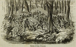
The Battle of Point Pleasant, also known as the Battle of Kanawha and the Battle of Great Kanawha, was the only major action of Dunmore's War. It was fought on October 10, 1774, between the Virginia militia and Shawnee and Mingo warriors. Along the Ohio River near modern-day Point Pleasant, West Virginia, forces under the Shawnee chief Cornstalk attacked Virginia militiamen under Colonel Andrew Lewis, hoping to halt Lewis's advance into the Ohio Valley. After a long and furious battle, Cornstalk retreated. After the battle, the Virginians, along with a second force led by Lord Dunmore, the Royal Governor of Virginia, marched into the Ohio Valley and compelled Cornstalk to agree to a treaty, which ended the war.

Cornstalk was a Shawnee leader in the Ohio Country in the 1760s and 1770s. His name in the Shawnee language was Hokoleskwa. Little is known about his early life. He may have been born in the Province of Pennsylvania. In 1763, he reportedly led a raid against British American colonists in Pontiac's War. He first appears in historical documents in 1764, when he was one of the hostages surrendered to the British as part of the peace negotiations ending Pontiac's War.

The western theater of the American Revolutionary War (1775–1783) was the area of conflict west of the Appalachian Mountains, the region which became the Northwest Territory of the United States as well as what would become the states of Arkansas, Kentucky, Louisiana, Missouri, and Tennessee. The western war was fought between American Indians with their British allies in Detroit, and American settlers south and east of the Ohio River, and also the Spanish as allies of the latter.
Blackfish, was a Native American leader, war chief of the Chillicothe band of the Shawnee tribe.
Wakatomika was the name of two 18th century Shawnee villages in what is now the U.S. state of Ohio. The name was also spelled Wapatomica, Waketomika, Waketomica, and Waketameki, among other variations, but the similar name Wapakoneta was a different Shawnee village. Both Wakatomikas were destroyed in raids, the first by colonial Virginians in 1774, the second by Kentuckians in 1786.

Lower Shawneetown, also known as Shannoah or Sonnontio, was an 18th-century Shawnee village located within the Lower Shawneetown Archeological District, near South Portsmouth in Greenup County, Kentucky and Lewis County, Kentucky. The population eventually occupied areas on both sides of the Ohio River, and along both sides of the Scioto River in what is now Scioto County, Ohio. It was added to the National Register of Historic Places on 28 April 1983. It is near the Bentley site, a Madisonville Horizon settlement inhabited between 1400 CE and 1625 CE. Nearby, to the east, there are also four groups of Hopewell tradition mounds, built between 100 BCE and 500 CE, known as the Portsmouth Earthworks.
Kispoko is the name of one of the five divisions of the Shawnee, a Native American people. The Kispoko were the smallest of the five septs or divisions during the 18th century. They lived among the Creek in the Upper South and Southeast as early as 1650, having been driven from their Ohio country homeland by the Iroquois Confederacy during the Beaver Wars. They returned to Ohio about 1759. The other four divisions were the Chalahgawtha, Mekoche, Pekowi, and Hathawekela. Together these divisions formed the loose confederacy that was the Shawnee tribe. The septs tended to serve different functions for the overall confederacy.
Snake was the English language name of two Shawnee leaders prominent in the history of the Ohio Country: Peteusha and Shemanetoo. They were both commonly referred to as "Snake" in historical records, or by variations such as "Black Snake" or "Captain Snake," so it is often difficult to determine which individual was being referred to. On a number of occasions, the two Snakes both signed a letter or appeared together, so it is clear they were two different people. There may have been additional Shawnees called "Snake," further complicating the matter. According to historian John Sugden, "it is unlikely if the biographies of these chiefs will ever be completely disentangled."
Captain Logan, also known as Spemica Lawba, James Logan, or simply Logan, was a Shawnee warrior who lived in present-day Ohio. Although he opposed the expansion of the United States into Shawnee lands, following the Treaty of Greenville in 1795, he became one of many Shawnees who sought to preserve Shawnee independence by maintaining peaceful relations with the United States. When the War of 1812 reached Ohio, Logan served as a scout and guide for the American military.

Quatawapea or John Lewis, also known as Captain Lewis and Colonel Lewis and ‘’’Captain Johnny’’’, was a Shawnee leader for whom Lewistown, Ohio, is named.
 Non-Hel-E-Ma sign located on Emerson Road.