
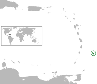
Barbados is an island country in the Lesser Antilles of the West Indies, in the Caribbean region of the Americas, and the most easterly of the Caribbean Islands. It is 34 kilometres in length and up to 23 km (14 mi) in width, covering an area of 432 km2 (167 sq mi). It is in the western part of the North Atlantic, 100 km (62 mi) east of the Windward Islands and the Caribbean Sea. Barbados is located roughly 13°N of the equator. It is about 168 km (104 mi) east of both the countries of Saint Lucia and Saint Vincent and the Grenadines and 180 km (110 mi) south-east of Martinique and 400 km (250 mi) north-east of Trinidad and Tobago. Barbados is outside the principal Atlantic hurricane belt. Its capital and largest city is Bridgetown.

The Canary Islands, also known informally as the Canaries, are a Spanish region and archipelago in the Atlantic Ocean, in Macaronesia. At their closest point to the African mainland, they are 100 kilometres west of Morocco. They are the southernmost of the autonomous communities of Spain. The archipelago is economically and politically European and is part of the European Union.
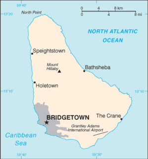
Barbados is a continental island in the North Atlantic Ocean and is located at 13°10' north of the equator, and 59°32' west of the Prime Meridian. As the easternmost isle of the Lesser Antilles in the West Indies, Barbados lies 160 kilometres (100 mi) east of the Windward Islands and Caribbean Sea. The maritime claim for Barbados is a territorial sea of 12 nmi, with an exclusive economic zone of 200 nmi which gives Barbados a total maritime area of 186,898 km2 (72,162 sq mi). Of the total EEZ area, 70,000 km2 is set aside for offshore oil exploration. A pending application to UNCLOS has placed for consideration a continental shelf 200 nmi to the east and south. To the west, most of Barbados' maritime boundaries consist of median lines with neighbours. These neighbours include: Martinique, and Saint Lucia to the northwest, Saint Vincent and the Grenadines to the west, Trinidad and Tobago and Venezuela to the southwest, and Guyana to the southeast.

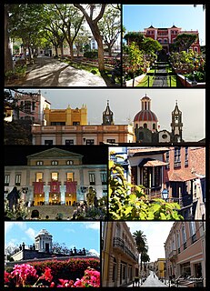
Tenerife is the largest and most populous island of the Canary Islands. It is home to 43% of the total population of the archipelago. With a land area of 2,034 square kilometres (785 sq mi) and a population of 966,354 inhabitants at the end of 2020, it is also the most populous island of Spain and of Macaronesia.

Montes Teneriffe is a range on the northern part of the Moon's near side. It was named after Tenerife, one of the Canary Islands.

Teide, or Mount Teide, is a volcano on Tenerife in the Canary Islands, Spain. Its summit is the highest point in Spain and the highest point above sea level in the islands of the Atlantic.

Mons Pico is a solitary lunar mountain that lies in the northern part of the Mare Imbrium basin, to the south of the dark-floored crater Plato and on the southern rim of a ghost crater. This peak forms part of the surviving inner ring of the Imbrium basin, continuing to the northwest and with the Montes Teneriffe and Montes Recti ranges, and probably to the southeast with the Montes Spitzbergen. This mountain feature is thought to have been named by Johann Hieronymus Schröter for Pico del Teide on Tenerife.

The Parish of Saint Peter is one of eleven parishes in the Caribbean island country of Barbados. It is named after the Christian Apostle and patron saint, Saint Peter. It is located in the north of Barbados, and is the only parish besides Saint Lucy that extends from the east coast to the west.
Tenerife lace or “roseta canaria”is a needle lace from Canary Islands. The first name comes from the fact that the lace made on the islands was exported from that island. The origin of this lace is uncertain and it is not known on which island the technique was born.
La Orotava is a town and a municipality in the northern part of Tenerife, one of the Canary Islands of Spain. The area of the municipality stretches from the north coast to the mountainous interior, and includes the summit of the Teide volcano, Canary Islands' and Spain's highest point at 3,718 m. At 207.31 km2, it is the largest municipality of the island of Tenerife. The population is 41,255 (2013).
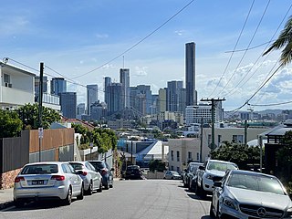
Teneriffe is an inner suburb of Brisbane, Australia, 2.5 kilometres (1.6 mi) north-east of the CBD. lt borders Fortitude Valley to the west, Newstead to the north and New Farm to the south.
The following is an alphabetical list of topics related to the nation of Barbados.
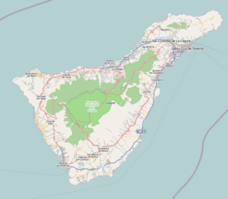
Teide National Park is a national park located in Tenerife, Canary Islands, Spain.

The Museum of Science and the Cosmos, is an astronomy, technology, and science museum located in the city of San Cristóbal de La Laguna on Tenerife island, in the Spanish Canary Islands of Macaronesia. It belongs to the Cabildo de Tenerife and the Tenerife Organization of Museums and Centers. The museum opened in 1993 under the initiative of the Cabildo and the Instituto de Astrofisica de Canarias (IAC). It is considered the primary astronomy and science museum of the Canary Islands and the Macaronesian archipelago.

Mount Teneriffe in central Victoria, Australia, is a distinctive granite formation, 444 m (1,457 ft) above sea level. It takes its name from the island of Tenerife in Spain.

Mount Teneriffe is a mountain located in King County of Washington state. The mountain is 1,459 meters high and is located at the western edge of the Cascade Range on land managed by Mount Baker-Snoqualmie National Forest. Its nearest higher peak is Green Mountain, 1.18 miles (1.90 km) to the northeast. The mountain takes its name from the island of Tenerife in Spain.
