Picture Canyon Natural and Cultural Preserve

Last updated
Picture Canyon Archeological Site
Picture Canyon Rio De Flag Trees.jpg
USA Arizona location map.svg
Red pog.svg
LocationEl Paso Flagstaff Road, Flagstaff, Arizona
Coordinates 35°13′45″N111°33′12″W / 35.22903°N 111.55347°W / 35.22903; -111.55347 Coordinates: 35°13′45″N111°33′12″W / 35.22903°N 111.55347°W / 35.22903; -111.55347
Area30 acres (12 ha)
NRHP reference No. 07001349 [1]
Added to NRHPJanuary 10, 2008

The Picture Canyon Natural and Cultural Preserve is an archaeological site and a nature preserve open to the public year-round, located in northeast Flagstaff, Arizona. [2] The preserve is used for educating the community about ecology, geology and archaeology along with general outdoor recreation.

Contents

History

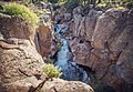
Picture Canyon was listed on the National Register of Historic Places on January 10, 2008.  The 478-acre preserve was purchased October 30, 2012 at a public auction on the steps of Coconino County Courthouse from the State Land Department by the City of Flagstaff for $4.8 million after several community groups rehabilitated the area and rallied decades for its protection.  An agreement was made with the Wildcat Hill Wastewater Treatment Plant, located immediately south of the preserve, to provide a constant water source for the riparian habitat and wildlife.  Reclaimed water is discharged into a pond which feeds the Rio de Flag through a rugged geological canyon composed of basalt rock.  Thousands of years ago, between 700 and 1300 AD, this area was home to the natives known as the Northern Sinagua (people without water). Picture Canyon is named for the large density of petroglyphs created by the Sinagua located along the river.  Hundreds of panels were created depicting archers, geometric shapes, and local animals like birds and turtles.

Trails and Natural Features

There are three trails within the preserve:

Related Research Articles

Flagstaff, Arizona City in Coconino County, Arizona, US

Flagstaff is a city in, and the county seat of, Coconino County in northern Arizona, in the southwestern United States. In 2019, the city's estimated population was 75,038. Flagstaff's combined metropolitan area has an estimated population of 139,097.

Montezuma Castle National Monument Ancient dwellings in Yavapai County, Arizona, US

Montezuma Castle National Monument protects a set of well-preserved dwellings located in Camp Verde, Arizona, which were built and used by the Sinagua people, a pre-Columbian culture closely related to the Hohokam and other indigenous peoples of the southwestern United States, between approximately AD 1100 and 1425. The main structure comprises five stories and about 20 rooms and was built over the course of three centuries.

Wupatki National Monument Protected area in Coconino County, Arizona

The Wupatki National Monument is a United States National Monument located in north-central Arizona, near Flagstaff. Rich in Native American archaeological sites, the monument is administered by the National Park Service in close conjunction with the nearby Sunset Crater Volcano National Monument. Wupatki was listed on the National Register of Historic Places on October 15, 1966. The listing included three contributing buildings and 29 contributing structures on 35,422 acres (14,335 ha).

McCormicks Creek State Park State park in Owen County, Indiana

McCormick's Creek State Park is the oldest state park in the U.S. state of Indiana, dedicated on July 4, 1916, as part of the state's centennial celebration. It is located 14 miles (23 km) west of Bloomington in Owen County. The park receives about 640,000 visitors annually.

Bandelier National Monument United States historic place

Bandelier National Monument is a 33,677-acre (13,629 ha) United States National Monument near Los Alamos in Sandoval and Los Alamos counties, New Mexico. The monument preserves the homes and territory of the Ancestral Puebloans of a later era in the Southwest. Most of the pueblo structures date to two eras, dating between 1150 and 1600 AD.

Sunset Crater Cinder cone in Coconino County, Arizona, US

Sunset Crater is a cinder cone located north of Flagstaff in the U.S. state of Arizona. The crater is within the Sunset Crater Volcano National Monument.

Virgin Islands National Park 14,700 acres in St. John, Virgin Islands (US) managed by the National Park Service

The Virgin Islands National Park is an American national park preserving about 60% of the land area of Saint John in the United States Virgin Islands, as well as more than 5,500 acres of adjacent ocean, and nearly all of Hassel Island, just off the Charlotte Amalie, Saint Thomas harbor.

Chiricahua National Monument National monument in southeastern Arizona

Chiricahua National Monument is a unit of the National Park System located in the Chiricahua Mountains of southeastern Arizona. The monument was established on April 18, 1924, to protect its extensive hoodoos and balancing rocks. The Faraway Ranch, which was owned at one time by Swedish immigrants Neil and Emma Erickson, is also preserved within the monument.

Northern Arizona Region of the US state of Arizona

Northern Arizona is an unofficial, colloquially-defined region of the U.S. state of Arizona. Generally consisting of Apache, Coconino, Mohave, Navajo, and Gila counties, the region is geographically dominated by the Colorado Plateau, the southern border of which in Arizona is called the Mogollon Rim.

Walnut Canyon National Monument is a United States National Monument located about 10 mi (16 km) southeast of downtown Flagstaff, Arizona, near Interstate 40. The canyon rim elevation is 6,690 ft (2,040 m); the canyon's floor is 350 ft lower. A 0.9 mi (1.4 km) long loop trail descends 185 ft (56 m) into the canyon passing 25 cliff dwelling rooms constructed by the Sinagua, a pre-Columbian cultural group that lived in Walnut Canyon from about 1100 to 1250 AD. Other contemporary habitations of the Sinagua people are preserved in the nearby Tuzigoot and Montezuma Castle national monuments.

Comanche National Grassland Protected area in southeast Colorado

Comanche National Grassland is a National Grassland located in southeastern Colorado, United States. It is the sister grassland of Cimarron National Grassland and contains both prairie grasslands and canyons. It is separated into two sections, each operated by a local ranger district, one of which is in Springfield and the other of which is in La Junta. The grassland is administered by the Forest Service together with the Pike and San Isabel National Forests, and the Cimarron National Grassland, from common headquarters located in Pueblo, Colorado.

White Tank Mountain Regional Park Regional park in Maricopa County, Arizona

The White Tank Mountain Regional Park is a large regional park located in west-central Maricopa County, Arizona. Encompassing 29,271 acres of desert and mountain landscape, it is the largest regional park in the county. The bulk of the White Tank Mountains range is located within the park's boundaries.

Sloan is an unincorporated community with a population of 105 in Clark County, Nevada, situated 18 miles southwest of Las Vegas. It is named for its limestone dolomite carnotite and was first settled in 1912 under the name Ehret; named for the founders' family name, but changed its name to Sloan on September 11, 1922. It is known for its canyon and its Sloan Canyon Petroglyph Site, Petroglyph Canyon, Black Mountain and is mostly located within the North McCullough Wilderness Area and is adjacent to the McCullough Range. It contains well-preserved petroglyphs and several hiking trails that allow visitors to photograph the petroglyphs. Sloan is also home to the George W. Dunaway Army Reserve Center which officially opened in April 2015, which is a large military area not open to the public. 2.7 miles west of Sloan was the site of the Bonanza Air Lines Flight 114 accident, which killed 29 people. Most of the residential areas are located on the main street, Sloan Road, and other smaller roads such as Arville Street, Hinston Street, and Roark Avenue. It is adjacent to Interstate 15 and is accessible from exit 25. The Sloan Canyon visitors center and trailhead to the Petroglyphs are accessible from a newer paved road through the Henderson neighborhood of Anthem, east of Interstate 15.

V Bar V Heritage Site Petroglyph site in central Arizona

The V Bar V Heritage Site is the largest known petroglyph site in the Verde Valley of central Arizona, and one of the best-preserved. The rock art site consists of 1,032 petroglyphs in 13 panels. Acquired by the Coconino National Forest in 1994, the site is protected and kept open to the public by the US Forest Service. Volunteers from the Verde Valley Archaeological Society and the Friends of the Forest provide interpretive tours and on-site management.

The Trail of the Ancients is a collection of National Scenic Byways located in the U.S. Four Corners states of Utah, Colorado, New Mexico, and Arizona. These byways comprise:

Deer Valley Petroglyph Preserve United States historic place in Maricopa County, Arizona

The Deer Valley Petroglyph Preserve, formerly known as the Deer Valley Rock Art Center, is a 47-acre nature preserve featuring over 1500 Hohokam, Patayan, and Archaic petroglyphs visible on 500 basalt boulders in the Deer Valley area of Phoenix, Arizona. In 1980, the US Army Corps of Engineers contracted Simon J. Bruder to conduct an archaeological investigation prior to the construction of the Adobe Dam at the Hedgpeth Hills. The petroglyphs are between 500 and 5,000 years old. The site was listed on the National Register of Historic Places in 1984, and it was also listed with the Phoenix Points of Pride. The preserve and museum are operated by the ASU College of Liberal Arts and Sciences's School of Human Evolution and Social Change.

History of Flagstaff, Arizona Review of the topic

Flagstaff is a city in, and the county seat of, Coconino County in northern Arizona, in the southwestern United States. Established as a modern settlement in 1876 and incorporated as a city in 1928, the land had previously been lived on by native peoples of the southwest, primarily the Sinagua. Mountaineer Antoine Leroux then traveled the area, with Edward Fitzgerald Beale following in his footsteps and establishing a trail through the city in the mid-1800s. With a local spring, a small settlement grew by the wagon road, and the town was dominated by the McMillan, Riordan, and Babbitt families. Focused on agricultural pursuits, these families constructed some historic red stone buildings that still stand today.

Tahquitz Falls

Tahquitz Falls is a waterfall on Tahquitz Creek in the west skirt of the city Palm Springs, in the U.S. state of California. The waterfall is located in lower Tahquitz Canyon, a short distance upstream from the visitor center. The name of the canyon and its waterfall is from the spirit Tahquitz, a Cahuilla native of the Agua Caliente folklore.

Rio de Flag River in Arizona, United States

The Rio de Flag, which has historically been known as the River de Flag and San Francisco river, is a river in Arizona that runs through Flagstaff, originating from the San Francisco Peaks before draining into the Little Colorado River. The river's age is unknown, though its first channels were around over one million years ago.

References

  1. "National Register Information System". National Register of Historic Places . National Park Service. November 2, 2013.
  2. "Picture Canyon Natural and Cultural Preserve | City of Flagstaff Official Website". www.flagstaff.az.gov. Retrieved 2018-09-03.