Rio de Flag

Last updated
Rio de Flag
Picture Canyon Rio De Flag Meadow.jpg
Physical characteristics
SourceLeroux Springs
  location San Francisco Peaks, Arizona
  coordinates 35°17′36″N111°43′30″W / 35.29333°N 111.72500°W / 35.29333; -111.72500
  elevation8,000 feet (2,400 m)
Mouth San Francisco Wash
  location
Walnut Creek, Arizona
  coordinates
35°14′12″N111°10′43″W / 35.23667°N 111.17861°W / 35.23667; -111.17861
  elevation
7,000 feet (2,100 m)
Length33 miles (53 km) [1]
Basin features
Tributaries 
  leftSchultz Creek
  rightSinclair Wash
WaterbodiesFrances Short Pond, Logan's Crossing
Waterfalls Picture Canyon

The Rio de Flag, which has historically been known as the River de Flag [2] and San Francisco river, [3] is a river in Arizona that runs through Flagstaff, originating from the San Francisco Peaks before draining into the Little Colorado River. The river's age is unknown, though its first channels were around over one million years ago. [4]

Contents

Headwaters

Four springs in the San Francisco Peaks originate the river; they would not produce enough water to maintain flow if not for the heavy rain and snowfall of the area supplementing the levels in the channel. [5] The main headwaters of the river are the Leroux Springs, located 1 mile (1.6 km) up Snowbowl Road just northwest of the city, [6] with Taylor Spring and Chimney Spring also sourcing it, and most of the south face snowmelt filling the river, too. [5] Edward Fitzgerald Beale and his men, in planning for his wagon road, visited the Leroux Springs on September 12, 1857. He described the spring and the start of the river as such: "Leroux's spring is one of transparent sparkling water, and bursts out of the side of the mountain and runs gurgling down for a quarter of a mile, where it loses itself in the valley. To reach it we found it necessary to turn from the course we were steering, and go up into a little mountain glen from which it flows into the valley." [7] Other springs of the river include Antelope/Old Town Spring, by the base of Mars Hill, and San Francisco Spring by the McMillan homestead. [8]

The San Francisco Peaks as seen from a stream by the Leroux Springs c. 1855 Reports of explorations and surveys, to ascertain the most practicable and economical route for a railroad from the Mississippi River to the Pacific Ocean (1855) (14760859085).jpg
The San Francisco Peaks as seen from a stream by the Leroux Springs c. 1855

The Leroux Springs are two separate sources: Big Leroux Spring and Little Leroux Spring. [5] [9] The Leroux Springs are named for Antoine Leroux, the guide of the Sitgreaves Expedition who led them to the spring in 1851; the bigger spring was given this name by Amiel Weeks Whipple on December 17, 1853 during a later expedition with him. [9] [10] During the Sitgreaves Expedition multiple new species were discovered at the spring, including Abert's squirrel, the Western Pocket Gopher, and Woodhouse's toad. It has been suggested that Flagstaff owes its existence to Leroux and this expedition; Beale was an admirer of Leroux and made sure his paths traveled by the springs, and in turn it was from Beale's wagon road that the city developed. [9] In 1882, Thomas S. Sedgewick of the railroad company planned to construct a water pipeline to connect Big Leroux Spring to Flagstaff, following the course of the river, but the pipeline was not built. [2] The flow of Big Leroux Spring was measured in 1949 at 29 gallons per minute, while the average flow between 2004 and 2013 was 13.5 gallons per minute. During the 20th century, the springs had been modified and sequestered to provide water for the city and for different private owners, with underground pipes particularly reducing the flow. With less need for water from the springs in the 21st century, a project to restore natural flow took place in 2013. [9]

River route

Picture Canyon Waterfall.jpg
Waterfall at Picture Canyon
Bottomless Pit Rio de Flag Flagstaff.png
The 'Bottomless Pit' c. 1915

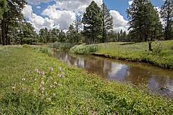
From the mountains, the river roughly follows Route 180 towards the city of Flagstaff. Its Cheshire Wetlands area begins downstream before the city proper, at Cheshire Park near the Museum of Northern Arizona. [6] [11] As the river starts to turn southeast with the highway, Schultz Creek drains into it. The river continues south through downtown Flagstaff, with the Frances Short Pond having formed by Thorpe Park in the west of the city. Here the river crosses Route 66 and starts to turn east again, Sinclair Wash drains into it; the river then crosses Interstate 40 (I-40) at Willow Bend, where the I-40 Wetlands are located. The river then turns northeast towards East Flagstaff and passes through Foxglenn Park before crossing back over I-40 and Route 66 and falling into Picture Canyon, where there is a waterfall between narrow canyon walls. Beyond this, the river crosses Townsend-Winona Road but then follows the road's loop until Logan's Crossing, a wetland and bird sanctuary. After Logan's Crossing, the river turns east-northeast towards the San Francisco Wash and Little Colorado River. [6] The river from Picture Canyon and Logan's Crossing is mostly fed by water from a nearby wastewater treatment plant. [12] [13] At the east of the city lies the 'Bottomless Pit'; volcanism in the area created pits where small lakes of the river formed, [4] and when it rains heavily the river begins to fill in a pit that lies on Kaibab Limestone with a sinkhole 2,000 feet (610 m) deep beneath, the water eventually draining down underground while the pit appears to be bottomless. [14] [15]

Before meeting the Little Colorado, the river has a confluence with Walnut Creek. [4] The river did not always run its current course through the city, as during the 20th century it was rerouted in certain areas to allow urban expansion and as a means of flood control. [16] In 2020, $52 million was awarded to Flagstaff to finish the Rio de Flag Flood Control Project, with Arizona Senator Kyrsten Sinema visiting the project. [17]

Geology

Geologically, the substrate of the river is an igneous rock called basalt, which has many vertical cracks through which water can travel down to the clay sandstone below; where there is stronger flow the water could cut through this rock, but the river is typically small enough that most spring water is absorbed by the stream bed. Other surfaces also affect the river. The soil of the drainage basin of the river absorbs moisture, allowing a slow release into the river of naturally filtered water, but fires in the area can damage this soil. Within the urban areas, non-absorbent surfaces mean that unfiltered rainwater is entering the river, which can contain pollutants poisonous to fish. [5]

Related Research Articles

<span class="mw-page-title-main">Grand Canyon</span> Steep-sided canyon carved by the Colorado River in Arizona, United States

The Grand Canyon is a steep-sided canyon carved by the Colorado River in Arizona, United States. The Grand Canyon is 277 miles (446 km) long, up to 18 miles (29 km) wide and attains a depth of over a mile.

<span class="mw-page-title-main">Flagstaff, Arizona</span> City in Arizona

Flagstaff is the county seat of Coconino County, Arizona, in the southwestern United States. As of the 2020 United States census, the city's population was 76,831.

<span class="mw-page-title-main">Colorado River</span> Major river in the western United States and Mexico

The Colorado River is one of the principal rivers in the Southwestern United States and in northern Mexico. The 1,450-mile-long (2,330 km) river, the 5th longest in the United States, drains an expansive, arid watershed that encompasses parts of seven U.S. states and two Mexican states. The name Colorado derives from the Spanish language for "colored reddish" due to its heavy silt load. Starting in the central Rocky Mountains of Colorado, it flows generally southwest across the Colorado Plateau and through the Grand Canyon before reaching Lake Mead on the Arizona–Nevada border, where it turns south toward the international border. After entering Mexico, the Colorado approaches the mostly dry Colorado River Delta at the tip of the Gulf of California between Baja California and Sonora.

<span class="mw-page-title-main">Glen Canyon Dam</span> Dam in Arizona, USA

Glen Canyon Dam is a concrete arch-gravity dam in the southwestern United States, located on the Colorado River in northern Arizona, near the city of Page. The 710-foot-high (220 m) dam was built by the Bureau of Reclamation (USBR) from 1956 to 1966 and forms Lake Powell, one of the largest man-made reservoirs in the U.S. with a capacity of more than 25 million acre-feet (31 km3). The dam is named for Glen Canyon, a series of deep sandstone gorges now flooded by the reservoir; Lake Powell is named for John Wesley Powell, who in 1869 led the first expedition to traverse the Colorado River's Grand Canyon by boat.

<span class="mw-page-title-main">Lake Powell</span> Reservoir in Utah and Arizona, United States

Lake Powell is a reservoir on the Colorado River in Utah and Arizona, United States. It is a major vacation destination visited by approximately two million people every year. It holds 24,322,000 acre-feet (3.0001×10¹⁰ m3) of water when full, second in the United States to only Lake Mead - though Lake Mead has fallen below Lake Powell in size several times during the 21st century in terms of volume of water, depth and surface area.

<span class="mw-page-title-main">Little Colorado River</span> River in Arizona, United States

The Little Colorado River is a tributary of the Colorado River in the U.S. state of Arizona, providing the principal drainage from the Painted Desert region. Together with its major tributary, the Puerco River, it drains an area of about 26,500 square miles (69,000 km2) in eastern Arizona and western New Mexico. Although it stretches almost 340 miles (550 km), only the headwaters and the lowermost reaches flow year-round. Between St. Johns and Cameron, most of the river is a wide, braided wash, only containing water after heavy snowmelt or flash flooding.

<span class="mw-page-title-main">Gila River</span> River in New Mexico and Arizona, United States

The Gila River is a 649-mile-long (1,044 km) tributary of the Colorado River flowing through New Mexico and Arizona in the United States. The river drains an arid watershed of nearly 60,000 square miles (160,000 km2) that lies mostly within the U.S., but also extends into northern Sonora, Mexico.

<span class="mw-page-title-main">San Juan River (Colorado River tributary)</span> River in Utah, United States

The San Juan River is a major tributary of the Colorado River in the Southwestern United States, providing the chief drainage for the Four Corners region of Colorado, New Mexico, Utah, and Arizona. Originating as snowmelt in the San Juan Mountains of Colorado, it flows 383 miles (616 km) through the deserts of northern New Mexico and southeastern Utah to join the Colorado River at Glen Canyon.

<span class="mw-page-title-main">Salt River (Arizona)</span> River in Gila and Maricopa counties in Arizona, United States

The Salt River is a river in Gila and Maricopa counties in Arizona, United States, that is the largest tributary of the Gila River. The river is about 200 miles (320 km) long. Its drainage basin covers about 13,700 square miles (35,000 km2). The longest of the Salt River's many tributaries is the 195-mile (314 km) Verde River. The Salt's headwaters tributaries, the Black River and East Fork, increase the river's total length to about 300 miles (480 km). The name Salt River comes from the river's course over large salt deposits shortly after the merging of the White and Black Rivers.

<span class="mw-page-title-main">Lees Ferry</span> Historical Colorado River ferry crossing

Lees Ferry is a site on the Colorado River in Coconino County, Arizona in the United States, about 7.5 miles (12.1 km) southwest of Page and 9 miles (14 km) south of the Utah–Arizona state line.

<span class="mw-page-title-main">Santa Fe River (New Mexico)</span> River in Santa Fe and Sandoval counties in New Mexico, United States

The Santa Fe River is a river in Santa Fe and Sandoval counties in New Mexico, United States, that is a tributary of the Rio Grande.

<span class="mw-page-title-main">Mojave Road</span> Historical trails and roads

The Mojave Road, also known as Old Government Road, is a historic route and present day dirt road across what is now the Mojave National Preserve in the Mojave Desert in the United States. This rough road stretched 147 miles (237 km) from Beale's Crossing, to Fork of the Road location along the north bank of the Mojave River where the old Mojave Road split off from the route of the Old Spanish Trail/Mormon Road.

The Hardy River is a 26-kilometer (16 mi)-long Mexican river formed by residual agricultural waters from the Mexicali Valley, and running into the Colorado River. The river is believed to have been an ancient channel of the Colorado, as well as the primary outflow for the prehistoric Lake Cahuilla.

<span class="mw-page-title-main">Course of the Colorado River</span> Route and confluences of the Colorado River in the United States and Mexico

The Colorado River is a major river of the western United States and northwest Mexico in North America. Its headwaters are in the Rocky Mountains where La Poudre Pass Lake is its source. Located in north central Colorado it flows southwest through the Colorado Plateau country of western Colorado, southeastern Utah and northwestern Arizona where it flows through the Grand Canyon. It turns south near Las Vegas, Nevada, forming the Arizona–Nevada border in Lake Mead and the Arizona–California border a few miles below Davis Dam between Laughlin, Nevada and Needles, California before entering Mexico in the Colorado Desert. Most of its waters are diverted into the Imperial Valley of Southern California. In Mexico its course forms the boundary between Sonora and Baja California before entering the Gulf of California. This article describes most of the major features along the river.

<span class="mw-page-title-main">Otis R. Marston</span> American river runner (1894–1979)

Otis Reed "Dock" Marston was an American writer, historian and Grand Canyon river runner who participated in a large number of river-running firsts. Marston was the eighty-third person to successfully complete the water transit of the Grand Canyon. He spent the last thirty years of his life writing his magnum opus on the history of the first 100 Grand Canyon river runners. In researching his book, he amassed a vast collection of material on early river runners in the American Southwest, especially runners of the Green and Colorado Rivers. His collection is housed in the Huntington Library in San Marino, California.

<span class="mw-page-title-main">Rose–Baley Party</span> Emigrant wagon train going to California

The Rose–Baley Party was the first European American emigrant wagon train to traverse the 35th parallel route known as Beale's Wagon Road, established by Edward Fitzgerald Beale, from Zuni Pueblo, New Mexico to the Colorado River near present-day Needles, California.

<span class="mw-page-title-main">History of Flagstaff, Arizona</span> Review of the topic

Flagstaff is a city in, and the county seat of, Coconino County in northern Arizona, in the southwestern United States. Established as a modern settlement in 1876 and incorporated as a city in 1928, the land had previously been lived on by native peoples of the southwest, primarily the Sinagua. Mountaineer Antoine Leroux then traveled the area, with Edward Fitzgerald Beale following in his footsteps and establishing a trail through the city in the mid-1800s. With a local spring, a small settlement grew by the wagon road, and the town was dominated by the McMillan, Riordan, and Babbitt families. Focused on agricultural pursuits, these families constructed some historic red stone buildings that still stand today.

<span class="mw-page-title-main">Walnut Creek (Arizona)</span> Stream in Coconino County, Arizona

Walnut Creek is a major stream in Coconino County, Arizona that is part of the Little Colorado River drainage basin. The creek flows about 34 miles (55 km) in a northeasterly direction from south of Flagstaff to near Winona.

<span class="mw-page-title-main">Picture Canyon Natural and Cultural Preserve</span> United States historic place

The Picture Canyon Natural and Cultural Preserve is an archaeological site and a nature preserve open to the public year-round, located in northeast Flagstaff, Arizona. The preserve is used for educating the community about ecology, geology and archaeology along with general outdoor recreation.

References

  1. "Resources". Friends of the Rio de Flag. Retrieved 2020-04-13. See document "FOR Rio de Flag Main Stem Channel Length Data – by Collis Lovely"
  2. 1 2 Olberding, Susan Deaver (2002). Fort Valley Then and Now (PDF). Fort Valley Pub. p. 6. ISBN   978-09720048-0-0.
  3. Whipple, A. W. (1855). Report of Explorations for a Railway Route, Near the Thirty-fifth Parallel of Latitude, for the Mississippi River to the Pacific Ocean (PDF). p. 23.
  4. 1 2 3 "New Publication explores the origin and geology of the Rio de Flag of Flagstaff, Arizona | e-Magazine of the AZ Geological Survey". blog.azgs.arizona.edu. Retrieved 2020-04-07.
  5. 1 2 3 4 "Rio de Flag: Flow". www2.nau.edu. Retrieved 2020-04-07.
  6. 1 2 3 "Map of the Rio". Friends of the Rio de Flag. Retrieved 2020-04-07.
  7. Beale, Edward F. (May 12, 1858). "The report of the superintendent of the wagon road from Fort Defiance to the Colorado river" (PDF). US House of Representatives: 51.
  8. "Springs of the Rio". Friends of the Rio de Flag. Retrieved 2020-04-07.
  9. 1 2 3 4 Monroe, Stephen; Grahame, John; Clark, Shannon (2013). "Leroux Redux: Release of Flow at Big Leroux Spring near Flagstaff, Arizona" (PDF). Biennial Conference of Research on the Colorado Plateau.
  10. Coody, Robert A. (1988). Historic Fort Valley, Arizona An Archeological Survey and Historic Overview (PDF). US Department of the Interior, National Park Service. pp. 30–35.
  11. "Cheshire Wetland". Friends of the Rio de Flag. Retrieved 2020-04-07.
  12. "Picture Canyon". Friends of the Rio de Flag. Retrieved 2020-04-07.
  13. "Logan's Crossing". Friends of the Rio de Flag. Retrieved 2020-04-07.
  14. "Arizona geological wonder is seen by few". KTAR.com. 2013-07-15. Retrieved 2020-04-07.
  15. "Bottomless Pit in the Kaibab Limestone, Flagstaff (ca. 1915)". AZGS. 2018-09-17. Retrieved 2020-04-07.
  16. "Rio de Flag: Flood Control". www2.nau.edu. Retrieved 2020-04-07.
  17. "Sinema Tours Rio de Flag Flood Control Project with Flagstaff Leaders". Senator Kyrsten Sinema. Retrieved 2020-04-07.