Puerco River

Last updated
Puerco River
Rio Puerco or “Perky”
Puerco River in Petrified Forest NP.jpg
Flowing near Puerco Pueblo,
in Petrified Forest National Park
USA Arizona relief location map.svg
Red pog.svg
The mouth of the Puerco River on the Little Colorado River, northeast-central Arizona
Location
Country United States
State Arizona, New Mexico
Region Colorado Plateau
Physical characteristics
Sourcenear Hosta Butte
  location McKinley County, New Mexico
  coordinates 35°34′33″N108°10′52″W / 35.57583°N 108.18111°W / 35.57583; -108.18111 [1]
  elevation7,930 ft (2,420 m) [2]
Mouth Little Colorado River
  location
near Holbrook, Navajo County, Arizona
  coordinates
34°53′20″N110°07′17″W / 34.88889°N 110.12139°W / 34.88889; -110.12139 [1]
  elevation
5,102 ft (1,555 m) [1]
Length167 mi (269 km) [3]
Basin size2,654 sq mi (6,870 km2)
Discharge 
  locationnear Chambers, Arizona
  average70 cu ft/s (2.0 m3/s)
  minimum0 cu ft/s (0 m3/s)
  maximum17,800 cu ft/s (500 m3/s)

The Puerco River or Rio Puerco is a tributary of the Little Colorado River in northwestern New Mexico and northeastern Arizona. It flows through arid terrain, including the Painted Desert.

Contents

Name

The Puerco River is sometimes called Rio Puerco of the West, to distinguish it from the Rio Puerco of the East that rises in the same vicinity but flows east to the Rio Grande. [4]

Although the word Puerco means pig, it also used to mean dirty or filthy in Spanish, this usage in the southwest United States is better translated as Dirty River or Muddy River due its high content of silt and mud. [5]

Geography

The intermittent river is the main tributary of the Little Colorado River, which is a tributary of the Colorado River. It drains an area of about 2,654 square miles (6,870 km2) and is 167 miles (269 km) long. [3] The river's average discharge is very low, less than 70 cubic feet per second (2.0 m3/s) in normal years, because its drainage basin is extremely dry. For most of the year, the Puerco River is a braided wash containing little or no water, although large flash floods can occur in downpours.

Course

The Puerco River in McKinley County, New Mexico. Puerco River in flood August, 2010.jpg
The Puerco River in McKinley County, New Mexico.

The Puerco River headwaters are on the western slopes of the Continental Divide of the Americas, 0.5 miles (0.80 km) east of Hosta Butte, in McKinley County, New Mexico. It flows first north, and then west, through a wide desert valley bordered by high rocky buttes and cliffs. It passes under Interstate 40, and receives the South Fork Puerco River from the right-south near Gallup. For most of its remaining course, I-40 and the former Atchison, Topeka and Santa Fe Railway (now the BNSF Railway) tracks follow the river's valley.

The Puerco River crosses into Apache County, Arizona. It flows by Houck, Sanders, and Chambers, and then flows through the middle of Petrified Forest National Park, where Lithodendron Wash enters from the left-north. The river then flows southwest to its confluence with the Little Colorado River, near the eastern side of Holbrook. [6]

Discharge

The United States Geological Survey (USGS) operates a Puerco River stream gauge 1 mile (1.6 km) southwest of Chambers in Arizona. The maximum discharge recorded by this gauge between 1971 and 2009 was 17,800 cubic feet per second (500 m3/s) on Sept. 30, 1971, and the minimum discharge was often zero, from a drainage basin of 2,156 square miles (5,580 km2). [7]

Water pollution

Navajos in the Puerco River Valley have used surface waters in the Puerco River for livestock watering for decades. [8]

From the 1950s through the early 1980s, the Puerco River ran almost continuously from being fed by mining wastewater, some untreated, from uranium mines upstream. [9]

Radioactive spill

The Church Rock uranium mill spill is one of the worst radioactive spills in U.S. history. On July 16, 1979, a tailings pond at the Church Rock uranium mill, owned by United Nuclear Corporation, breached its dam and 93 million gallons (350,000 m3) of radioactive, acidic uranium tailings solution flowed into the North Fork of the Puerco River. [10] Approximately 1,100 short tons (1,000  t ) of uranium mine waste contaminated 250 acres (100 ha) of land and up to 50 miles (80 km) of the Puerco River. [11] [12]

See also

Related Research Articles

<span class="mw-page-title-main">Rio Grande</span> Major river forming part of the US–Mexico border

The Rio Grande, known in Mexico as the Río Bravo del Norte or simply the Río Bravo, is one of the principal rivers in the southwestern United States and in northern Mexico. The length of the Rio Grande is 1,896 miles (3,051 km), making it the 4th longest river in North America by main stem. It originates in south-central Colorado, in the United States, and flows to the Gulf of Mexico. The Rio Grande drainage basin (watershed) has an area of 182,200 square miles (472,000 km2); however, the endorheic basins that are adjacent to and within the greater drainage basin of the Rio Grande increase the total drainage-basin area to 336,000 square miles (870,000 km2).

<span class="mw-page-title-main">Church Rock, New Mexico</span> Human settlement in New Mexico, United States

Church Rock is a census-designated place (CDP) in McKinley County, New Mexico, United States. The population was 1,128 at the 2010 census. Church Rock is named for Church Rock, a prominent natural landmark with the same name.

<span class="mw-page-title-main">Painted Desert (Arizona)</span> Desert in Arizona

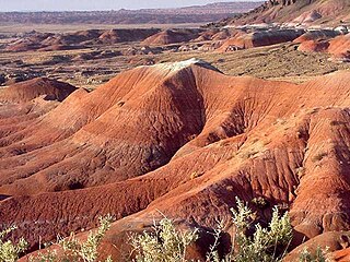
The Painted Desert is a United States desert of badlands in the Four Corners area, running from near the east end of Grand Canyon National Park and southeast into Petrified Forest National Park. It is most easily accessed from the north portion of Petrified Forest National Park. The Painted Desert is known for its brilliant and varied colors: these include the more common red rock, but also shades of lavender.

<span class="mw-page-title-main">Colorado River</span> Major river in the western United States and Mexico

The Colorado River is one of the principal rivers in the Southwestern United States and in northern Mexico. The 1,450-mile-long (2,330 km) river drains an expansive, arid watershed that encompasses parts of seven U.S. states and two Mexican states. The name Colorado derives from the Spanish language for "colored reddish" due to its heavy silt load. Starting in the central Rocky Mountains of Colorado, it flows generally southwest across the Colorado Plateau and through the Grand Canyon before reaching Lake Mead on the Arizona–Nevada border, where it turns south toward the international border. After entering Mexico, the Colorado approaches the mostly dry Colorado River Delta at the tip of the Gulf of California between Baja California and Sonora.

<span class="mw-page-title-main">Little Colorado River</span> River in Arizona, United States

The Little Colorado River is a tributary of the Colorado River in the U.S. state of Arizona, providing the principal drainage from the Painted Desert region. Together with its major tributary, the Puerco River, it drains an area of about 26,500 square miles (69,000 km2) in eastern Arizona and western New Mexico. Although it stretches almost 340 miles (550 km), only the headwaters and the lowermost reaches flow year-round. Between St. Johns and Cameron, most of the river is a wide, braided wash, only containing water after heavy snowmelt or flash flooding.

<span class="mw-page-title-main">Gila River</span> River in New Mexico and Arizona, United States

The Gila River is a 649-mile-long (1,044 km) tributary of the Colorado River flowing through New Mexico and Arizona in the United States. The river drains an arid watershed of nearly 60,000 square miles (160,000 km2) that lies mainly within the U.S., but also extends into northern Sonora, Mexico.

<span class="mw-page-title-main">San Juan River (Colorado River tributary)</span> River in Utah, United States

The San Juan River is a major tributary of the Colorado River in the Southwestern United States, providing the chief drainage for the Four Corners region of Colorado, New Mexico, Utah, and Arizona. Originating as snowmelt in the San Juan Mountains of Colorado, it flows 383 miles (616 km) through the deserts of northern New Mexico and southeastern Utah to join the Colorado River at Glen Canyon.

<span class="mw-page-title-main">Dolores River</span> River in Colorado and Utah in the United States

The Dolores River is a tributary of the Colorado River, approximately 241 miles (388 km) long, in the U.S. states of Colorado and Utah. The river drains a rugged and arid region of the Colorado Plateau west of the San Juan Mountains. Its name derives from the Spanish El Rio de Nuestra Señora de Dolores, River of Our Lady of Sorrows. The river was explored and possibly named by Juan Maria Antonio Rivera during a 1765 expedition from Santa Fe.

<span class="mw-page-title-main">White River (Green River tributary)</span> River in Colorado and Utah, United States

White River is a river, approximately 195 miles (314 km) long, in the U.S. states of Colorado and Utah and is a tributary of the Green River.

<span class="mw-page-title-main">Rio Chama</span> River of Colorado and New Mexico in the United States

The Rio Chama, a major tributary river of the Rio Grande, is located in the U.S. states of Colorado and New Mexico. The river is about 130 miles (210 km) long altogether. From its source to El Vado Dam its length is about 50 miles (80 km), from El Vado Dam to Abiquiu Dam is about 51 miles (82 km), and from Abiquiu Dam to its confluence with the Rio Grande is about 34 miles (55 km).

<span class="mw-page-title-main">Rio Puerco (Rio Grande tributary)</span> River in New Mexico, United States

The Rio Puerco is a tributary of the Rio Grande in the U.S. state of New Mexico. From its source on the west side of the Nacimiento Mountains, it flows about 230 miles (370 km), generally south to join the Rio Grande about 20 miles (32 km) south of Belen and about 50 miles (80 km) south of Albuquerque. Its drainage basin is about 7,350 square miles (19,000 km2) large, of which probably about 1,130 square miles (2,900 km2) are noncontributing.

<span class="mw-page-title-main">Piedra River (Colorado)</span> River

The Piedra River is a river in the U.S. state of Colorado. It drains parts of Archuleta, Hinsdale, and Mineral counties along a mainstem length of about 40 miles (64 km). The river flows through a series of isolated box canyons, emptying into the San Juan River at Navajo Lake. Its name stems from the Spanish word, piedra, meaning rock.

<span class="mw-page-title-main">Church Rock uranium mill spill</span> Radioactive spill in New Mexico on July 16, 1979

The Church Rock uranium mill spill occurred in the U.S. state of New Mexico on July 16, 1979, when United Nuclear Corporation's tailings disposal pond at its uranium mill in Church Rock breached its dam. The accident remains the largest release of radioactive material in U.S. history, having released more radioactivity than the Three Mile Island accident four months earlier.

<span class="mw-page-title-main">Navajo River</span> River

Navajo River is a 54-mile-long (87 km) tributary of the San Juan River. It flows from a source in the South San Juan Wilderness of Conejos County, Colorado southwest past Chromo, Colorado. The river dips into New Mexico, passing just north of Dulce before heading northwest to a confluence with the San Juan in Archuleta County, Colorado. A large portion of its water is diverted across the Continental Divide to the Rio Grande basin as part of the San Juan–Chama Project.

<span class="mw-page-title-main">Course of the Colorado River</span> Route and confluences of the Colorado River in the United States and Mexico

The Colorado River is a major river of the western United States and northwest Mexico in North America. Its headwaters are in the Rocky Mountains where La Poudre Pass Lake is its source. Located in north central Colorado it flows southwest through the Colorado Plateau country of western Colorado, southeastern Utah and northwestern Arizona where it flows through the Grand Canyon. It turns south near Las Vegas, Nevada, forming the Arizona–Nevada border in Lake Mead and the Arizona–California border a few miles below Davis Dam between Laughlin, Nevada and Needles, California before entering Mexico in the Colorado Desert. Most of its waters are diverted into the Imperial Valley of Southern California. In Mexico its course forms the boundary between Sonora and Baja California before entering the Gulf of California. This article describes most of the major features along the river.

<span class="mw-page-title-main">Black Creek (Arizona)</span> Water body in Apache County, AZ, and McKinley County, NM

Black Creek of Arizona is a 55-mi (89 km) long north tributary of the Puerco River, in northeast Arizona and northwest New Mexico.

<span class="mw-page-title-main">Defiance Plateau</span> Region in the United States

The Defiance Plateau, part of the geologic Defiance Uplift, is an approximately 75-mile (121 km) long, mostly north-trending plateau of Apache County, Arizona, with its east and southeast perimeter, as parts of San Juan and McKinley Counties, New Mexico.

This is a list of notable events relating to the environment in 1979. They relate to environmental law, conservation, environmentalism and environmental issues.

References

  1. 1 2 3 "Puerco River". Geographic Names Information System (GNIS). United States Geological Survey. February 8, 1980. Retrieved May 28, 2010.
  2. Source elevation derived from Google Earth search using GNIS source coordinates.
  3. 1 2 "The National Map". U.S. Geological Survey. Retrieved Feb 25, 2011.
  4. "Feature Detail Report – DecisionCard #694.9 Puerco River". USGS GNIS. Retrieved 2 January 2017.
  5. Garland D. Bills, Neddy A. Vigil (2008). The Spanish Language of New Mexico and Southern Colorado: A Linguistic Atlas. University of New Mexico Press. ISBN   9780826345493.
  6. USGS Topo Maps for United States (Map). Cartography by United States Geological Survey. ACME Mapper. Retrieved 2010-10-01.
  7. "Water-Data Report 2009: 09396100 Puerco River near Chambers, AZ" (PDF). United States Geological Survey. Retrieved May 29, 2010.
  8. Chris Shuey Contaminant Loading on the Puerco River A Historical Overview Archived 2008-10-14 at the Wayback Machine Southwest Research and Information Center, October 14, 1992
  9. Gault, Ramona (September 13, 1989), "Navajos inherit a legacy of radiation", In These Times , Chicago
  10. Pasternak, Judy (2010). Yellow Dirt: A Poisoned Land and a People Betrayed. Free Press. p. 149. ISBN   978-1416594826.
  11. Brendan Giusti, Radiation Spill in Church Rock Still Haunts 30 Years Later, The Daily Times (Farmington, New Mexico), July 16, 2009, Section: Local
  12. Carl Jensen, Project Censored (U.S.) 20 Years of Censored News Archived 2010-01-06 at the Wayback Machine Seven Stories Press, July 1, 2003, p. 84, ISBN   1-888363-52-5