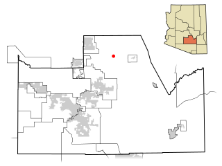
Queen Valley is a census-designated place (CDP) in north central Pinal County, Arizona, United States. The population was 820 at the 2000 census.

The Funeral Mountains are a short, arid mountain range in the United States along the California-Nevada border approximately 100 mi (160 km) west of Las Vegas. The mountains are considered a subrange of the Amargosa Range that form the eastern wall of Death Valley.

The Avra Valley is a 50-mile (80 km) long northwest–southeast valley, bordering the west of Tucson, Arizona. The Tucson Mountains are at the valley's center-east, with suburbs ranging east of the Tucson Mountains and trending northwest to the Avra Valley's northeast. This entire northwest stretch from Tucson contains the northwest trending Interstate 10, the route to Casa Grande and Phoenix. The northeast of the valley contains Marana on I-10, the Pinal Airpark, an aircraft storage park, and other communities along I-10. Avra Valley Airport is a general aviation airport in Marana, located about 15 miles (24 km) northwest of Tucson and being used for storage of classic propeller-era airliners.

The Tucson Mountains are a minor mountain range west of Tucson, Arizona. The Tucson Mountains, including Wasson Peak, are one of four notable mountain ranges surrounding the Tucson Basin. The Santa Catalina Mountains lie to the northeast, the Rincon Mountains are to the east of Tucson, and the Santa Rita Mountains lie to the south. Additionally the Sierrita Mountains lie due south, the Roskruge Mountains lie to the west across Avra Valley, the Silver Bell Mountains lie to the northwest, and the Tortolita Mountains lie to the north across the Santa Cruz Valley.

The Mormon Mountains are located in Lincoln and Clark counties in Nevada, between 16 and 28 miles (45 km) northwest of Mesquite on I–15 in the Virgin Valley, east of the Meadow Valley Mountains and Meadow Valley and northeast of Moapa Valley. The highest point in the range is Mormon Peak, at 7,414 feet (2,260 m) above sea level. Another smaller mountain range lies to the east, called the East Mormon Mountains. The south fork of the Toquop Wash drains the east side of the range and continues on through the N–S linear ridge of the East Mormon Mountains.

The New York Mountains are a small mountain range found in northeastern San Bernardino County in California, USA. The range's northeastern area lies in southeastern Nevada. The range lies just south of the small community of Ivanpah, and north of the Lanfair Valley. The mountains are part of the mountain ranges, cones, mountains, and landforms in the Mojave National Preserve. The mountains reach an elevation of 7,533 feet (2,296 m), and run in a mostly southwest-northeasterly direction between the Providence Mountains and the McCullough Range approximately five miles into Nevada and border the northwest corner of the Piute Valley of Nevada-California.
The Tule Desert is located in southeastern Nevada in Lincoln County, near the Utah state line. The desert lies northeast of the Mormon Mountains, south of the Clover Mountains and west of the Tule Springs Hills.

The Muggins Mountains is a mountain range in southwest Arizona east of Yuma, Arizona, northeast of the Gila Mountains, and east of the Laguna Mountains. The Castle Dome Mountains lie to the northeast across the broad Castle Dome Plain. The Muggins Mountains Wilderness occupies the southwest portion of the range.

The Delamar Mountains are a mountain range in Lincoln County, Nevada, named after Captain Joseph Raphael De Lamar. The range extends for approximately 50 miles (80 km) in a NNE–SSW orientation with a width of about 11 miles (18 km). Surrounding ranges include the Burnt Springs Range and the Chief Range to the north, the Clover Mountains and Meadow Valley Mountains to the east and the Sheep Range and South Pahroc Range on the west. The Delamar Valley lies to the west, the Kane Springs Valley to the east and the Coyote Springs Valley lies to the south of the range.

The Meadow Valley Mountains is a mountain range in Lincoln and Clark counties in southern Nevada. The range is a narrow north to northeast trending ridgeline with a length of about 40 miles (64 km). The Clover Mountains lie to the north, Meadow Valley Wash and the Mormon Mountains to the east, the Moapa Valley to the southeast, Arrow Canyon Range to the south, Coyote Springs Valley to the southwest and the Kane Springs Valley and Delamar Mountains to the west and northwest.

The Little Ajo Mountains is a mountain range in southern Arizona, in extreme western Pima County, Arizona. The city of Ajo sits on the northeast of this small mountain range. Both the mountain range and city take their name from the Spanish word for garlic.

The Arica Mountains are a small mountain range in northern Riverside County, California. The range lies along the south edge of Rice Valley 6.2 miles (10.0 km) southwest of the old Rice townsite on California State Route 62. They lie 6 miles (9.7 km) north of the Little Maria Mountains and 9 miles (14 km) southwest of the Turtle Mountains. The Granite Mountains lie about 8 miles to the west. They are in the Colorado Desert, in the Lower Colorado River Valley region. They are north the Palen Mountains and Big Maria Mountains; and northwest of Blythe, California.

The Cerro Colorado Mountains are a low mountain range in southern Pima County, Arizona, USA. The highest point of the range is. The range consists of a NNW–SSE trending ridge with several shorter ridges extending off the main ridge to the ENE. The higher portions of the range cover an area of about 21 km2 (8.1 sq mi), with dimensions of 6.8 km (4.2 mi) by 4.0 km (2.5 mi).

The Altar Valley is a 45-mile (72 km) long north-south valley, trending slightly northeast from Sasabe, Arizona on the Mexico border to the Avra Valley west of the Tucson Mountains. It is delimited by Arizona State Route 86, from east-to-west on the north separating it from the Avra Valley which then trends northwesterly, merging into the plains and drainage of the Santa Cruz River.
The San Luis Mountains are a small, lower elevation mountain range of central-southern Pima County Arizona adjacent to the U.S.-Mexico border, northeast of Sasabe, Arizona–Sasabe, Sonora.
The West Silver Bell Mountains are a small 10 mile (16 km) long mountain range of south-central Arizona, United States. The range lies in the north-central arid Sonoran Desert; the Madrean Sky Islands region of southeast Arizona, around Tucson is adjacent to the southeast.
The Antelope Valley of southern Eureka County is a small 35 mi long valley, surrounded by four mountain ranges. Antelope Wash flows north, to endorheic flatlands at the valley's north end. Eureka, Nevada lies 20 mi east nestled among mountain ranges. From Eureka U.S. Route 50 travels west through the north end of the valley on a route to Austin.
Shadow Valley is a north to northwest flowing drainage within the Mojave Desert of San Bernardino County, California. A section of Interstate 15 passes through the valley between Mountain Pass and Halloran Springs. The valley drains to the north from the west flank of the Mescal Range, the Ivanpah Mountains and Cima Dome within the Mojave National Preserve. North of I-15 the valley lies between Clark Mountains to the east and Shadow Mountain to the west. To the north of Shadow Mountain, Kingman Wash becomes the main drainage and turns to the west south of the Kingston Range. The Mesquite Mountains and the Mesquite Valley are to the northeast.
The Las Guijas Mountains are a small northwest - southeast trending mountain range in southern Pima County, Arizona. The range is approximately 12 kilometres (7.5 mi) long by 4 km (2.5 mi). Surrounding ranges includes the Cerro Colorado Mountains to the northeast, the Tumacacori Mountains of Santa Cruz County to the east, the San Luis Mountains to the south and the Baboquivari Mountains across the Altar Valley to the west. Arivaca is immediately to the southeast and the old mining townsite of Las Guijas is in the wash just north of the range.
