Related Research Articles
Bullville is a populated place located in the Town of Crawford in Orange County, New York, United States. It is located at the junction of routes NY-17K and NY-302. Bulville is the site of a United States Post Office and is served by the postal code 10915.

Castle Rock Hoodoos Provincial Park is a provincial park in British Columbia, Canada. Located on the Deadman Plateau northwest of Kamloops, the park was originally named Deadman Hoodoos Provincial Park and was created on July 23, 1997 and was 34 hectares in size. The park was reduced in size to 16 hectares on April 11, 2001, and renamed at the same time.
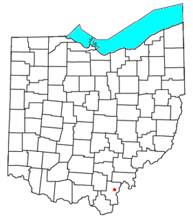
Kerr is an unincorporated community in southeastern Springfield Township, Gallia County, Ohio, United States. It has a post office with the ZIP code 45643.

Seis am Schlern is an Alpine village in South Tyrol, in the Trentino-Alto Adige/Südtirol region of northern Italy. It is a frazione of the comune of Kastelruth.

Eloxochitlán de Flores Magón, formerly known as San Antonio Eloxochitlán, is a city and municipality in the Mexican state of Oaxaca. It is part of the Teotitlán District in the north of the Cañada Region. Approximately 96% of the inhabitants of the municipality speak the indigenous Tecóatl Mazatec.
The Apalachee River is a 74-mile-long (119 km) tributary of the Oconee River in the U.S. state of Georgia. It rises north of Lawrenceville in eastern Gwinnett County and flows southeast to join the Oconee River in Lake Oconee west of Greensboro.
Ethel is an unincorporated community in Pushmataha County, Oklahoma, United States, six miles east of Antlers. Ethel is located at 34°13′46″N95°32′39″W.
Union Airport was a former civil airport and military airfield located approximately 5 miles (8.0 km) north-northeast of Lincoln, Nebraska. Today the land formerly occupied by the airport is an agricultural industrial estate and fields.
Harryhogan is an unincorporated community in Northumberland County, in the U.S. state of Virginia.
Bis Ii Ah Wash may refer to either of two places in Apache County, Arizona:
Kinlichee Creek is a stream in the U.S. state of Arizona. It is located northeast of the census-designated place of Ganado in Apache County.
Little Lithodendron Wash is a stream located in Navajo County, Arizona, east of Sun Valley and west of the ghost town of Adamana.
Initially built as a combined passenger and transport ship for Turkey, Hugo Zeye was taken over by Nazi Germany's Kriegsmarine at the outbreak of the war and completed as a torpedo training ship. Equipped with eight torpedo tubes, the ship was used to train torpedo personnel for surface combat ships in the Baltic Sea.

Chinle Creek is a tributary stream of the San Juan River in Apache County, Arizona and San Juan County, Utah. Its source is at 36°53′40″N109°44′37″W, the confluence of Laguña Creek and the Chinle Wash arroyo. Its name is derived from the Navajo word ch'inili meaning 'where the waters came out'. Its sources is in Canyon de Chelly National Monument where Canyon de Chelly and Canyon del Muerto have their confluence at an elevation of 5,616 feet at 36°08′35″N109°29′17″W. It then trends northwest to its confluence with Laguña Creek where it forms Chinle Creek, 7 miles northeast of Dennehotso, Arizona at an elevation of 4,774 feet / 1,455 meters.
Osbornes Mills is an unincorporated community in Roane County, in the U.S. state of West Virginia.
Coyote Wash is a tributary stream of Whiskey Creek in the watershed of the San Juan River and Colorado River. The confluence with Whiskey Creek lies within the Canyon de Chelly National Monument. It is entirely in Apache County, Arizona. Its mouth is located at an elevation of 7,080 feet (2,160 m) at its confluence with Whiskey Creek. Its source is at an elevation of 7,096 feet (2,163 m) at the confluence of Crystal Creek and Cattail Wash 36°04′52″N109°08′56″W.

Penn Park is an unincorporated community in Otsego Township, Steuben County, in the U.S. state of Indiana.
References
Coordinates: 35°52′30″N109°32′39″W / 35.87500°N 109.54417°W