Related Research Articles

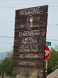
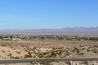
Ehrenberg, also historically spelled "Ehrenburg", is an unincorporated community and census-designated place (CDP) in La Paz County, Arizona, United States. The population was 1,470 at the 2010 census. Ehrenberg is named for its founder, Herman Ehrenberg.

Poston is an unincorporated community and census-designated place (CDP) in La Paz County, Arizona, United States, in the Parker Valley. The population was 285 at the 2010 census, down from 389 in 2000.

Selby-on-the-Bay is a census-designated place (CDP) in Anne Arundel County, Maryland, United States, for the 2000 census, at which time its population was 3,674. It was added to the Mayo CDP for the 2010 census.

The Kadéï River is a tributary of the Sangha River that flows through Cameroon and the Central African Republic. Its total drainage basin is 24,000 km2. The river rises from the eastern Adamawa Plateau, southeast of Garoua-Boulaï in Cameroon's East Province. The Kadéï is swelled by two tributaries, the Doumé at Mindourou and the Boumbé, before flowing east into the Central African Republic. At Nola, the Kadéï meets the Mambéré and becomes the Sangha. The Kadéï is part of the Congo River basin.

Swan Township is located in Warren County, Illinois, United States. As of the 2010 census, its population was 265 and it contained 126 housing units.

Norris Point is a community in the Canadian province of Newfoundland and Labrador.

Telmen is a sum of Zavkhan Province in western Mongolia. In 2005, its population was 2,820.

La Paz was a short-lived early gold mining town along on the western border of current-day La Paz County, Arizona. The town grew quickly after gold was discovered nearby in 1862. La Paz, Spanish for peace, was chosen as the name in recognition of the feast day for Our Lady of Peace. Originally located in the New Mexico Territory, the town became part of the Arizona Territory when President Abraham Lincoln established the new territory in 1863. In 1983 the newly-formed County of La Paz adopted the name, long after the town had become a ghost town.

The Black Mountains of northwest Arizona are an extensive, mostly linear, north-south trending 75 miles (121 km) long mountain range. It forms the north-south border of southwest Mohave County as it borders the eastern shore of the south-flowing Colorado River from Hoover Dam.

The Parker Valley is located along the Lower Colorado River within the Lower Colorado River Valley region, in southwestern Arizona and southeastern California.

Sobrado is a municipality in the province of León, Castile and León, Spain.

Al-Salihiyah is a municipality and a neighborhood of Damascus, Syria. It lies to the northwest of the old walled city of Damascus and about 2.4 kilometres (1.5 mi) southeast the Citadel at the foot of Mount Qasioun. The quarter is famous for its cemetery of holy men. It houses the Syrian Parliament building. It also has the Hanabila Mosque.
Taylor Hollow is a hamlet in the town of Collins in Erie County, New York, United States.
Quartzsite Elementary School District 4 is a school district in La Paz County, Arizona, United States.
Dos Palmas Spring is an artesian spring in Riverside County, California where it lies at the foot of the Orocopia Mountains. It is only one of several such springs in the area that create an oasis in the Colorado Desert there.
Clip, or Clip Landing, was a steamboat landing and mill settlement in Yuma County, Arizona Territory. The site in the present day is a ghost town, on the east bank of the Colorado River in La Paz County, Arizona. The settlement was located 70 miles up river from Yuma. It lies at an elevation of 223 feet, just south of Clip Wash, and the road to the Clip Mine at the top of the wash, 8 miles southeast of the mill.
Callville Wash is an ephemeral stream or wash in Clark County, Nevada. It was named for Callville the riverport settlement founded in 1866, at its mouth where it had its original confluence with the Colorado River.
Boulder Wash is an ephemeral stream or wash in Clark County, Nevada. Its mouth is at its confluence with the Boulder Wash Cove of Lake Mead at an elevation 1,276 feet / 389 meters at when Lake Mead is at its full level. Currently as the reservoir is at a much lower level its mouth is found at approximately 36°10′07″N114°33′07″W. Its source is at 36°13′36″N114°31′22″W at an elevation of 2,841 feet / 866 meters in the Black Mountains. It flows down a canyon into the upper Pinto Valley southwestward before turning southeastward to Boulder Wash Cove.
Devils Slide State Forest is a 290-acre (120 ha) state forest in Stark, New Hampshire. It is part of a contiguous area of more than 2,000 acres (810 ha) of protected lands that includes the Kauffmann Forest and Percy State Forest.

Mihaylovski Cove is the 5 km wide cove indenting for 1.3 km the northwest coast of South Bay in Livingston Island, Antarctica that is entered west of Ereby Point and east of Lukovo Point, and has its head fed by Kamchiya Glacier. The area was known to early 19th century sealers who operated from nearby Johnsons Dock. The feature is named after the brothers Petar Mihaylovski, physician at St. Kliment Ohridski base during the 2007/08 and subsequent seasons, and Hristo Mihaylovski, engineer in the national Antarctic campaign during 2015/16 and subsequent seasons.
References
Coordinates: 33°36′43″N114°31′10″W / 33.61194°N 114.51944°W