Chinle is a census-designated place (CDP) in Apache County, Arizona. The name in Navajo means "flowing out" and is a reference to the location where the water flows out of the Canyon de Chelly. The population was 4,518 at the 2010 census.
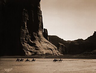
Canyon de Chelly National Monument was established on April 1, 1931, as a unit of the National Park Service. Located in northeastern Arizona, it is within the boundaries of the Navajo Nation and lies in the Four Corners region. Reflecting one of the longest continuously inhabited landscapes of North America, it preserves ruins of the indigenous tribes that lived in the area, from the Ancestral Puebloans to the Navajo. The monument covers 83,840 acres and encompasses the floors and rims of the three major canyons: de Chelly, del Muerto, and Monument. These canyons were cut by streams with headwaters in the Chuska Mountains just to the east of the monument. None of the land is federally owned. Canyon de Chelly is one of the most visited national monuments in the United States.

Northeast Arizona is a region of the U.S. state of Arizona commonly including Apache County and Navajo County. Some notable towns there are St. Johns, Eagar, Holbrook, Show Low, Winslow, Window Rock, Fort Defiance, Ganado, Chinle, and Kayenta.

Kanab Creek is one of the many tributaries of the Colorado River. It begins in Kane County, Utah, just south of the watershed to the Great Basin and flows 125 miles (201 km) south to the Colorado River.

Temescal Creek is an approximately 29-mile-long (47 km) watercourse in Riverside County, in the U.S. state of California. Flowing primarily in a northwestern direction, it connects Lake Elsinore with the Santa Ana River. It drains the eastern slopes of the Santa Ana Mountains on its left and on its right the western slopes of the Temescal Mountains along its length. With a drainage basin of about 1,000 square miles (2,600 km2), it is the largest tributary of the Santa Ana River, hydrologically connecting the 720-square-mile (1,900 km2) San Jacinto River and Lake Elsinore watersheds to the rest of the Santa Ana watershed. However, flowing through an arid rain shadow zone of the Santa Ana Mountains, and with diversion of ground water for human use, the creek today is ephemeral for most of its length, except for runoff from housing developments and agricultural return flows.

The Battle of Canyon de Chelly was fought in 1864 as part of the Navajo Wars. It was a successful operation for the United States Army which precipitated the Long Walk and was the final major military engagement between the Navajo and the Americans. The battle ended with the fall of the main Navajo settlements of Canyon de Chelly in present-day northern Arizona.

Chinle Valley is a 65-mile (105 km) long valley located mostly in Apache County Arizona. Chinle Creek continues north into Utah to meet the San Juan River (Utah).

The Defiance Plateau, part of the geologic Defiance Uplift, is an approximately 75-mile (121 km) long, mostly north-trending plateau of Apache County, Arizona, and its east and southeast perimeter, are parts of San Juan and McKinley Counties, New Mexico.

Del Muerto is a census-designated place (CDP) in Apache County, Arizona, United States. The population was 329 at the 2010 census.
San Simon River is an ephemeral river, or stream running through the San Simon Valley in Graham and Cochise County, Arizona and Hidalgo County, New Mexico. Its mouth is at its confluence with the Gila River at Safford in Graham County. Its source is located at 31°51′21″N109°01′27″W.

Laguña Creek also formerly also known as Tyende Creek, is a stream in the Navajo and Apache Counties of Arizona. Laguña Creek has its source at 36°41′15″N110°30′36″W, at the confluence of Long Canyon and Dowozhiebito Canyon at an elevation of 6325 feet / 1928 meters at the head of Tsegi Canyon. Its mouth is in the Chinle Valley at its confluence with Chinle Wash which together forms Chinle Creek, at an elevation of 4774 feet / 1455 meters. Chinle Creek is a tributary of San Juan River which is in turn a tributary of the Colorado River.
Dowozhiebito Canyon is a canyon in Navajo County, Arizona. The head of Dowozhiebito Canyon is at 36°49′48″N110°27′39″W. Laguña Creek has its headwaters at the mouth of Dowozhiebito Canyon, where the creeks from Long Canyon and Dowozhiebito Canyon have their confluence at an elevation of 6325 feet / 1928 meters at the head of Tsegi Canyon.
Long Canyon is a canyon in Navajo County, Arizona. The head of Long Canyon is at 36°50′04″N110°28′08″W. Laguña Creek has its headwaters at the mouth of Long Canyon, where the creeks from Long Canyon and Dowozhiebito Canyon have their confluence at an elevation of 6322 feet / 1927 meters at the head of Tsegi Canyon.

Chinle Creek is a tributary stream of the San Juan River in Apache County, Arizona and San Juan County, Utah. Its source is at 36°53′40″N109°44′37″W, the confluence of Laguña Creek with Chinle Wash where it forms Chinle Creek, 7 miles northeast of Dennehotso, Arizona at an elevation of 4,774 feet (1,455 m). Its mouth is at its confluence with the San Juan River at 37°11′53″N109°42′57″W at an elevation of 4,229 feet (1,289 m), 9 miles northeast of Mexican Hat, Utah.
Walker Creek is a stream in Apache County, Arizona. Its mouth is at an elevation of 4,688 feet / 1,429 meters at its confluence with Chinle Creek. Its source is located at 36°41′28″N109°15′04″W, the confluence of Alcove Canyon and Tah Chin Lini Canyon in the Carrizo Mountains, from which it flows west and northwest to Chinle Creek at 36°57′42″N109°41′35″W. Hogansaani Spring, a tributary, is located on the south side of Walker Creek, at an elevation of 5,102 feet (1,555 m), midway downstream Walker Creek to its confluence with Chinle Creek.
Coyote Wash is a tributary stream of Whiskey Creek in the watershed of the San Juan River and Colorado River. The confluence with Whiskey Creek lies within the Canyon de Chelly National Monument. It is entirely in Apache County, Arizona. Its mouth is located at an elevation of 7,080 feet (2,160 m) at its confluence with Whiskey Creek. Its source is at an elevation of 7,096 feet (2,163 m) at the confluence of Crystal Creek and Cattail Wash 36°04′52″N109°08′56″W.
Palm Canyon Wash is an arroyo and tributary ephemeral stream or wash of the Whitewater River, in Riverside County, California.
Bull Canyon is a canyon at the top of Palm Canyon Wash, which is a tributary to the Whitewater River, in Riverside County, California. Bull Canyon and the creek of Palm Canyon Wash heads at 33°36′47″N116°33′23″W, at an elevation of 6,165 feet in the southern western slope of a ridge in the San Jacinto Mountains. The waters of the creek of Palm Canyon Wash are augmented by Bull Canyon Spring at 33°35′22″N116°33′24″W, at an elevation of 5,331 feet / 1,625 meters. The mouth of Bull Canyon is at an elevation of 4,508 feet / 1,374 meters at the head of head of Palm Canyon. The mouth of an unnamed creek flows north down from Vandeventer Flat into the head of Palm Canyon at its confluence with Palm Canyon Wash at 33°34′08″N116°31′43″W at an elevation of 4,460 feet.
Alcove Canyon is a valley in Apache County in the U.S. state of Arizona. The valley lies southwest of the Carrizo Mountains and extends to Walker Creek.
Whitmire Creek is a stream tributary to Animas Creek within Hidalgo County, New Mexico. Its source is in Whitmire Canyon in the Peloncillo Mountains in Cochise County, Arizona. It is one of two creeks of that name that are tributary to Animas Creek in the Animas Valley. They both were named for J. B. Whitmire one of the first settlers that established the Whitmire Ranch in the area during the 1880s.
