
The Rio Grande, known in Mexico as the Río Bravo del Norte and as the Río Bravo, is one of the principal rivers in the southwestern United States and in northern Mexico. The length of the Rio Grande is 1,896 miles (3,051 km) and originates in south-central Colorado, in the United States, and flows to the Gulf of Mexico. The Rio Grande drainage basin (watershed) has an area of 182,200 square miles (472,000 km2); however, the endorheic basins that are adjacent to and within the greater drainage basin of the Rio Grande increase the total drainage-basin area to 336,000 square miles (870,000 km2).

Tierra Amarilla is a census-designated place in and the county seat of Rio Arriba County, New Mexico, United States.
Rio Arriba County is a county in the U.S. state of New Mexico. As of the 2010 census, the population was 40,246. Its county seat is Tierra Amarilla. Its northern border is the Colorado state line.

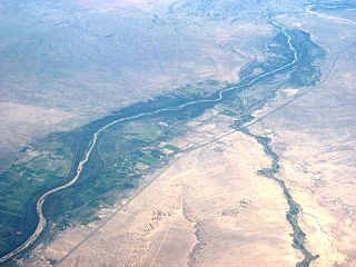
The Rio Chama, a major tributary river of the Rio Grande, is located in the U.S. states of Colorado and New Mexico. The river is about 130 miles (210 km) long altogether. From its source to El Vado Dam its length is about 50 miles (80 km), from El Vado Dam to Abiquiu Dam is about 51 miles (82 km), and from Abiquiu Dam to its confluence with the Rio Grande is about 34 miles (55 km).

Abiquiú is a census-designated place in Rio Arriba County, in northern New Mexico in the southwestern United States, about 53 miles (85 km) north of Santa Fe. As of 2010, the population was 231. Abiquiú's one school, an elementary school, is part of the Española Public Schools.

Abiquiu Lake is a reservoir located in Rio Arriba County, in northern New Mexico in the southwestern United States. Water of the Rio Chama is impounded by the earth-filled Abiquiu Dam, 1,800 feet long and 340 feet high, completed in 1963 and raised in 1986. The 5,200-acre (21 km2) lake is over 12 miles (20 km) long, and lies at elevations of 6,100–6,220 feet (1,859–1,896 m).

The Rio Puerco is a tributary of the Rio Grande in the U.S. state of New Mexico. From its source on the west side of the Nacimiento Mountains, it flows about 230 miles (370 km), generally south to join the Rio Grande about 20 miles (32 km) south of Belen and about 50 miles (80 km) south of Albuquerque. Its drainage basin is about 7,350 square miles (19,000 km2) large, of which probably about 1,130 square miles (2,900 km2) are noncontributing.
Canjilón Mountain is a 10,922 feet (3,329 m). mountain approximately six miles northeast of the village of Canjilón, in the Carson National Forest.
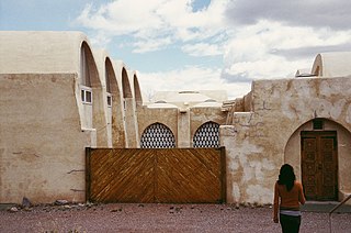
Dar al-Islam is a Muslim educational center located near Abiquiú, New Mexico, USA.

The Puerco River or Rio Puerco is a tributary of the Little Colorado River in northwestern New Mexico and northeastern Arizona. It flows through arid terrain, including the Painted Desert.
Fesere is one of the principal Tewa Pueblo ancestral sites in New Mexico, US. The prehistoric pueblo is situated on a mesa west or south of the Rio Chama, near Abiquiu, Rio Arriba County.

Santa Rosa de Lima was an early 18th-century Spanish settlement in the Rio Chama valley, near the present-day town of Abiquiu in Rio Arriba County, New Mexico, United States

Abiquiu Dam is a dam on the Rio Chama, located about 60 miles (97 km) northwest of Santa Fe in Rio Arriba County, New Mexico. Built and operated by the U.S. Army Corps of Engineers (USACE), the dam is an earth embankment structure 354 feet (108 m) high and 1,800 feet (550 m) long, containing 11.8 million cubic yards of fill. The dam forms Abiquiu Lake, one of the largest lakes in New Mexico with a full storage capacity of 1,369,000 acre-feet (1,689,000 dam3) and 5,200 acres (2,100 ha) of water. To date, the reservoir has never filled to capacity, with a record high of 402,258 acre-feet (496,178 dam3), 29.4% of full pool, on June 22, 1987. The dam's primary purpose is flood control, in addition to irrigation and municipal water storage, and hydroelectric generation.
Bernardo is an unincorporated community in Socorro County, New Mexico, United States, at the northern junction of US 60 and Interstate 25. Bernardo was named, circa 1902, after a friend of John Becker, a leading merchant in nearby Belen. The main point of interest is the nearby Bernardo Wildlife Management Area, visited by large flocks of sandhill cranes and other birds.
Heron Dam is a storage dam Rio Arriba County, in northern New Mexico in the southwestern United States, just north of the El Vado Dam. It is owned and operated by the United States Bureau of Reclamation. The dam is about 9 miles west of the town of Tierra Amarilla.

The Abiquiu Formation is a geologic formation found in northern New Mexico. Radiometric dating constrains its age to between 18 million and 27 million years, corresponding to the late Oligocene to Miocene epochs.
New Mexico State Road 554 is a 21.153 mi (34.0 km) long state highway in northern New Mexico, located in the Southwestern United States. NM 554 is located on the southern slope of the Tusas Mountains. The highway starts East of Abiquiú at an intersection with U.S. Route 84, crossing the Rio Chama, then paralleling El Rito creek, passing through the village of El Rito, and ending Northwest of Ojo Caliente at an intersection with NM 111.

The Arroyo del Agua Formation is a geologic formation in New Mexico. It preserves fossils dating back to the early Permian period.
