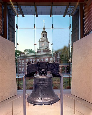
Philadelphia, commonly referred to as Philly, is the most populous city in the U.S. state of Pennsylvania and the second-most populous city in the Northeast megalopolis and Mid-Atlantic regions after New York City. Philadelphia is known for its extensive contributions to United States history, especially the American Revolution, and served as the nation's capital until 1800. It maintains contemporary influence in business and industry, culture, sports, and music. Philadelphia is the nation's sixth-most populous city, with a population of 1,603,797 in the 2020 census and is the urban core of the larger Delaware Valley, the nation's seventh-largest and one of the world's largest metropolitan regions consisting of 6.245 million residents in the metropolitan statistical area and 7.366 million residents in its combined statistical area.

The East Coast Greenway is a 3,000-mile (4,800 km) pedestrian and bicycle route between Maine and Florida along the East Coast of the United States. The nonprofit East Coast Greenway Alliance was created in 1991 with the goal to use the entire route with off-road, shared-use paths; as of 2021, over 1,000 mi (1,600 km) of the route (35%) meets these criteria. In 2020, the Greenway received over 50 million visits.
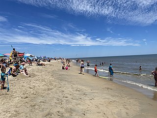
Cape Henlopen State Park is a Delaware state park on 5,193 acres (2,102 ha) on Cape Henlopen in Sussex County, Delaware, in the United States. William Penn made the beaches of Cape Henlopen one of the first public lands established in what has become the United States in 1682 with the declaration that Cape Henlopen would be for "the usage of the citizens of Lewes and Sussex County." Cape Henlopen State Park has a 24-hour and year-round fishing pier as well as campgrounds. The remainder of the park is only open from sunrise to sunset, and includes a bathhouse on the Atlantic Ocean, an area for surf-fishing, a disc golf course, and bicycle and walking paths. The beach at Herring Point is a popular surfing spot. The park is a stop on Delaware's Coastal Heritage Greenway.
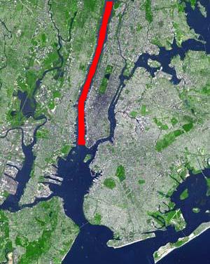
North River is an alternative name for the southernmost portion of the Hudson River in the vicinity of New York City and northeastern New Jersey in the United States.

Harbourfront is a neighbourhood on the northern shore of Lake Ontario within the downtown core of the city of Toronto, Ontario, Canada. Part of the Toronto waterfront, Harbourfront extends from Bathurst Street in the west, along Queens Quay, with its ill-defined eastern boundary being either Yonge Street or York Street. Its northern boundary is the Gardiner Expressway. Much of the district was former water lots filled in during the early 1900s to create a larger harbour district. After shipping patterns changed and the use of the Toronto harbour declined, the area was converted from industrial uses to a mixed-use district that is mostly residential and leisure.

The Port of Philadelphia is located on the Delaware River in Philadelphia in the U.S. state of Pennsylvania.

Transportation in Philadelphia involves the various modes of transport within the city and its required infrastructure. In addition to facilitating intracity travel, Philadelphia's transportation system connects Philadelphia to towns of its metropolitan area and surrounding areas within the Northeast megalopolis.

Penn's Landing is a waterfront area of Center City Philadelphia, Pennsylvania, situated along the Delaware River. Its name commemorates the landing of William Penn, the founder of Pennsylvania, in 1682. The actual landing site is farther south, in Chester. The city of Philadelphia purchased the right to use the name. Penn's Landing is bounded by Front Street to the west, the Delaware River to the east, Spring Garden Street to the north, and Washington Avenue to the south, and is primarily focused on the Christopher Columbus Boulevard corridor.

Hudson River Park is a waterfront park on the North River that extends from 59th Street south to Battery Park in the New York City borough of Manhattan. The park, a component of the Manhattan Waterfront Greenway, stretches 4.5 miles (7.2 km) and comprises 550 acres (220 ha), making it the second-largest park in Manhattan after the 843-acre (341 ha) Central Park.
Pennsport is a neighborhood in the South Philadelphia section of Philadelphia, Pennsylvania, United States.

Brooklyn Bridge Park is an 85-acre (34 ha) park on the Brooklyn side of the East River in New York City. Designed by landscape architecture firm Michael Van Valkenburgh Associates, the park is located on a 1.3-mile (2.1 km) plot of land from Atlantic Avenue in the south, under the Brooklyn Heights Promenade and past the Brooklyn Bridge, to Jay Street north of the Manhattan Bridge. From north to south, the park includes the preexisting Empire–Fulton Ferry and Main Street Parks; the historic Fulton Ferry Landing; and Piers 1–6, which contain various playgrounds and residential developments. The park also includes Empire Stores and the Tobacco Warehouse, two 19th-century structures, and is a part of the Brooklyn Waterfront Greenway, a series of parks and bike paths around Brooklyn.

The RiverLink Ferry is a passenger ferry service in the United States. The ferry crosses the Delaware River, connecting the Camden Waterfront, in Camden, New Jersey, with Penn's Landing, in Philadelphia, Pennsylvania. The ferry operates daily from May through September, and on Fridays through Sundays in April and October. Primarily, the system provides tourists with a means to reach waterfront attractions. The service carries over 200,000 passengers per year and first turned a profit in 2006.

Holts Landing State Park is a 203-acre (82 ha) Delaware state park northwest of Bethany Beach, Sussex County, Delaware, USA. Prior to becoming a state park the land of Holts Landing State Park was the Holt family farm. The Holts sold the land to the state of Delaware in 1957 and Holts Landing State Park was opened to the public in 1965. The park is on the southern shore of Indian River Bay. Holts Landing State Park is open for year-round recreation and features the only pier on the east coast of Delaware that has been purpose-built for crabbing, the recreational harvesting of blue crabs.

Boston Harborwalk is a public walkway that follows the edge of piers, wharves, beaches, and shoreline around Boston Harbor. When fully completed it will extend a distance of 47 miles (76 km) from East Boston to the Neponset River.
PennPraxis is the clinical arm of the School of Design at the University of Pennsylvania, and is a 501c(3) non-profit subsidiary of the Trustees of the University of Pennsylvania. Founded in 2012, PennPraxis has worked on ideas for urban planning for the city of Philadelphia, Pennsylvania, according to a "civic vision" it has for the city, including the Delaware River waterfront, and the western banks of the Schuylkill River.

The Port of Camden is situated on east bank of the Delaware River in Camden and Gloucester City in southern New Jersey. It is one of several ports in the Delaware Valley metro area port complex and is located near the mouth of Newtown Creek opposite the Port of Philadelphia. The port is one of the nation's largest for wood products, steel, cocoa and perishable fruit.

The East River Greenway is an approximately 9.44-mile-long (15.19 km) foreshoreway for walking or cycling on the east side of the island of Manhattan on the East River. It is part of the Manhattan Waterfront Greenway. The largest portions are operated by the New York City Department of Parks and Recreation. It is separated from motor traffic, and many sections also separate pedestrians from cyclists. The greenway is parallel to the Franklin D. Roosevelt East River Drive for a majority of its length.

Dilworth Park is a public park and open space along the western side of City Hall in Center City, Philadelphia. The one-half-acre (0.20 ha) park opened to the public on September 4, 2014.

The Washington Avenue Immigration Station was an immigrant processing facility in Philadelphia, Pennsylvania, United States located at the end of Washington Avenue at Pier 53 on the Delaware River, south of modern-day Penn's Landing waterfront district. The building opened in 1873 and was demolished in 1915.

Subaru Park is a soccer-specific stadium located in Chester, Pennsylvania, located next to the Commodore Barry Bridge on the waterfront along the Delaware River. The venue is home to the Philadelphia Union of Major League Soccer.
