The Tasman Sea is a marginal sea of the South Pacific Ocean, situated between Australia and New Zealand. It measures about 2,000 kilometres (1,200 mi) across and about 2,800 kilometres (1,700 mi) from north to south. The sea was named after the Dutch explorer Abel Janszoon Tasman, who was the first recorded European to encounter New Zealand and Tasmania. The British explorer Captain James Cook later extensively navigated the Tasman Sea in the 1770s as part of his first voyage of exploration.
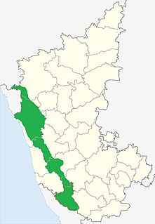
Malenadu is a region in the state of Karnataka in India. Malenadu covers the western and eastern slopes of the Western Ghats or Sahyadri mountain range, and is roughly 100 kilometers in width. It is situated between Coastal Karnataka and Bayaluseeme regions of Karnataka.
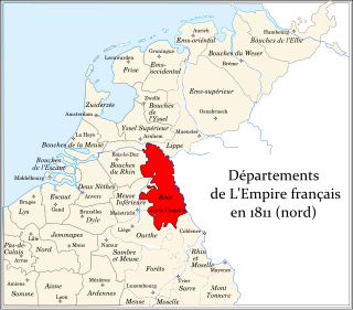
Roer[ʁo.ɛʁ] was a department of the First French Empire in present-day Germany and the Netherlands. It was named after the river Roer (Rur), which flows through the department. It was formed in 1795, when the Southern Netherlands and the left bank of the Rhine were occupied by the French. The department was formed from the duchies of Jülich and Cleves, the part of the Archbishopric of Cologne left of the Rhine, the Free City of Aachen, the Prussian part of the duchy of Guelders and some smaller territories. In 1805 the city of Wesel was added to the department. The capital was Aix-la-Chapelle (Aachen).

The Meetjesland is a historical region in the north-west of the province East Flanders in Belgium.
German submarine U-554 was a Type VIIC U-boat of Nazi Germany's Kriegsmarine during World War II. The submarine was laid down on 1 December 1939 at the Blohm & Voss yard in Hamburg as yard number 530, launched on 7 November 1940, and commissioned on 15 January 1941 under the command of Kapitänleutnant Dietrich Lohmann.

German submarine U-12 was a Type IIB U-boat of Nazi Germany's Kriegsmarine laid down on 20 May 1935 by Germaniawerft at Kiel and commissioned on 30 September.
German submarine U-777 was a German Type VIIC U-boat built in World War II, launched on 25 March 1944, and commissioned on 9 May, by its sole commander, Oberleutnant zur See Günter Ruperti.

Nieuw-Wehl is a village in the eastern Netherlands, about 10 km west of Doetinchem. It has a population of about 500. Before 1 January 2005, it was part of the municipality of Wehl, along with neighboring village Wehl. After the division, Nieuw-Wehl joined the municipality of Doetinchem. In 1925, a Roman Catholic church was built.

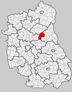
Turno is a village in the administrative district of Gmina Sosnowica, within Parczew County, Lublin Voivodeship, in eastern Poland. It lies approximately 23 kilometres (14 mi) south-east of Parczew and 54 km (34 mi) north-east of the regional capital Lublin.

Bà Rịa is a city in Bà Rịa–Vũng Tàu Province in the Southeast region of Vietnam. Bà Rịa is split from Vũng Tàu by a river crossed by Co May Bridge. This is the de jure seat of the province since most of the provincial administration agencies are located here. Bà Rịa officially became the provincial capital of Bà Rịa–Vũng Tàu from May 2, 2012, replacing Vũng Tàu in that role.
Okszów is a village in the administrative district of Gmina Chełm, within Chełm County, Lublin Voivodeship, in eastern Poland.
Tytusin is a village in the administrative district of Gmina Chełm, within Chełm County, Lublin Voivodeship, in eastern Poland. It lies approximately 12 kilometres (7 mi) north-west of Pokrówka, 11 km (7 mi) west of Chełm, and 54 km (34 mi) east of the regional capital Lublin.
Dorohusk is a village in Chełm County, Lublin Voivodeship, in eastern Poland, close to the border with Ukraine. It is the seat of the gmina called Gmina Dorohusk. It lies approximately 24 kilometres (15 mi) east of Chełm and 88 km (55 mi) east of the regional capital Lublin.
Wólka Okopska is a village in the administrative district of Gmina Dorohusk, within Chełm County, Lublin Voivodeship, in eastern Poland, close to the border with Ukraine. It lies approximately 7 kilometres (4 mi) west of Dorohusk, 17 km (11 mi) east of Chełm, and 81 km (50 mi) east of the regional capital Lublin.
Tuligłowy is a village in the administrative district of Gmina Krasnystaw, within Krasnystaw County, Lublin Voivodeship, in eastern Poland.
Owadów is a village in the administrative district of Gmina Jastrzębia, within Radom County, Masovian Voivodeship, in east-central Poland. It lies approximately 6 kilometres (4 mi) west of Jastrzębia, 12 km (7 mi) north of Radom, and 81 km (50 mi) south of Warsaw.

Sajópálfala is a village in Borsod-Abaúj-Zemplén County in northeastern Hungary.