Pigeon Forge Mill

Last updated
Pigeon Forge Mill

Oldmillpf2.jpg

The Old Mill and milldam
Location Off U.S. Route 441
Nearest city Pigeon Forge, Tennessee
Coordinates 35°47′18″N83°33′15″W / 35.78833°N 83.55417°W / 35.78833; -83.55417 Coordinates: 35°47′18″N83°33′15″W / 35.78833°N 83.55417°W / 35.78833; -83.55417
Area Less than 1 acre (0.40 ha) [1]
Built 1830
(188 years ago)
 (1830) [1]
Architect Isaac Love [1]
NRHP reference # 75001778
Added to NRHP June 10, 1975
(42 years ago)
 (1975-06-10) [1]

The Pigeon Forge Mill, commonly called the Old Mill, is a historic gristmill in the U.S. city of Pigeon Forge, Tennessee. Located along the West Fork of the Little Pigeon River, the mill complex currently consists of a millhouse, breastshot wheel, and milldam, all of which are operative. [1] The mill is the only structure in Pigeon Forge listed on the National Register of Historic Places.

Gristmill mill; grinds grain into flour

A gristmill grinds cereal grain into flour and middlings. The term can refer to both the grinding mechanism and the building that holds it.

Pigeon Forge, Tennessee City in Tennessee, United States

Pigeon Forge is a mountain resort city in Sevier County, Tennessee, in the southeastern United States. As of the 2010 census, the city had a total population of 5,875. Situated just 5 miles (8 km) north of Great Smoky Mountains National Park, Pigeon Forge is a tourist destination that caters primarily to Southern culture and country music fans. The city's attractions include Dollywood and Dollywood's Splash Country as well as numerous gift shops, outlet malls, amusement rides, and musical theaters.

Little Pigeon River (Tennessee) river in Sevier County, Tennessee

The Little Pigeon River is a river located entirely within Sevier County, Tennessee. It rises from a series of streams which flow together on the dividing ridge between the states of Tennessee and North Carolina inside the boundary of the Great Smoky Mountains National Park. The river is subdivided with three separate tributaries: East, Middle, and West.

Contents

Now a souvenir shop and restaurant, the Pigeon Forge Mill was once part of a small industrial complex established by local businessman Isaac Love (17831854) that included the iron forge for which the city was named. The mill was initially used to grind grain mainly corn, wheat, and oats for local farmers. During the U.S. Civil War (18611865), the mill powered several looms which produced cloth for the military. In the early 1900s, a generator was installed at the mill which provided electricity to the area until 1930. After the establishment of the Great Smoky Mountains National Park a few miles to the south in 1934, Pigeon Forge gradually evolved into a tourist boom town, and the mill became a popular stop for passing tourists. [1]

Great Smoky Mountains National Park national park in the USA

Great Smoky Mountains National Park is an American national park and a UNESCO World Heritage Site that straddles the ridgeline of the Great Smoky Mountains, part of the Blue Ridge Mountains, which are a division of the larger Appalachian Mountain chain. The border between Tennessee and North Carolina runs northeast to southwest through the centerline of the park. Great Smoky Mountains is the most visited national park in the United States with over 11.3 million recreational visitors in 2016. The Appalachian Trail passes through the center of the park on its route from Maine to Georgia. The park was chartered by the United States Congress in 1934 and officially dedicated by President Franklin D. Roosevelt in 1940.

Location

The Pigeon Forge Mill is situated on the east bank of the West Fork of the Little Pigeon River, which flows down out of the Great Smoky Mountains to the south and passes through Gatlinburg and Pigeon Forge before joining the Little Pigeon River proper in Sevierville a few miles downstream from the mill. The mill is accessible via Old Mill Avenue, which intersects US 441 near the center of Pigeon Forge. A small plaza of shops, known as the Old Mill Square, has developed in the mill's immediate vicinity.

Gatlinburg, Tennessee City in Tennessee, United States

Gatlinburg is a mountain resort city in Sevier County, Tennessee, United States. It is located 39 miles (63 km) southeast of Knoxville and had a population of 3,944 at the 2010 Census and an estimated U.S. Census population of 4,163 in 2017. It is a popular vacation resort, as it rests on the border of Great Smoky Mountains National Park along U.S. Route 441, which connects to Cherokee, North Carolina, on the southeast side of the national park.

Sevierville, Tennessee City in Tennessee, United States

Sevierville is a city in and the county seat of Sevier County, Tennessee, located in Eastern Tennessee. The population was 14,807 at the 2010 United States Census and 16,355 according to the 2014 census estimate.

U.S. Route 441 highway in the United States

U.S. Route 441 is a spur route of U.S. Route 41. It runs for 939 miles (1,511 km) from U.S. Route 41 in Miami, Florida to U.S. Route 25W in Rocky Top, Tennessee. Between its termini, US 441 passes through the states of Florida, Georgia, North Carolina and Tennessee. The route acts as a connector between several major urban areas, including Miami, Orlando, Ocala, Gainesville, Athens and Knoxville. It also crosses the Great Smoky Mountains National Park, where it meets the southwestern end of the Blue Ridge Parkway, and where no trucks or other commercial traffic are allowed.

History

Pigeon Forge Mill
Pigeon-forge-mill-entrance-tn1.jpg
Front facade
Pigeon-forge-mill-dam-tn1.jpg
Milldam

The Pigeon Forge Mill is located on land that was originally part of a 151-acre (61 ha) plot of land granted in 1810 to Mordecai Lewis (17511817), a Revolutionary War veteran from Virginia. Before his death, Lewis may have erected a tub mill along the river (no longer standing). [2] In 1817, Lewis's son-in-law, Isaac Love, built the iron forge for which the city would eventually be named. Taking advantage of a Tennessee state law that allowed tax incentives for the creation of iron works on unfarmable land, Love acquired over 7,000 acres (2,800 ha) of the surrounding country. Love mined brown hematite ore in the hills northeast of the forge, and transported the ore to the forge using ox-drawn wagons. The forge included a bloomery furnace which converted the ore into pig iron, and a 500-pound (230 kg) trip hammer that molded the pig iron into bar iron. [3]

American Revolutionary War War between Great Britain and the Thirteen Colonies, which won independence as the United States of America

The American Revolutionary War (1775–1783), also known as the American War of Independence, was an 18th-century war between Great Britain and its Thirteen Colonies which declared independence as the United States of America.

Virginia State of the United States of America

Virginia, officially the Commonwealth of Virginia, is a state in the Southeastern and Mid-Atlantic regions of the United States located between the Atlantic Coast and the Appalachian Mountains. The geography and climate of the Commonwealth are shaped by the Blue Ridge Mountains and the Chesapeake Bay, which provide habitat for much of its flora and fauna. The capital of the Commonwealth is Richmond; Virginia Beach is the most populous city, and Fairfax County is the most populous political subdivision. The Commonwealth's estimated population as of 2018 is over 8.5 million.

Limonite Oxide mineral

Limonite is an iron ore consisting of a mixture of hydrated iron(III) oxide-hydroxides in varying composition. The generic formula is frequently written as FeO(OH)·nH2O, although this is not entirely accurate as the ratio of oxide to hydroxide can vary quite widely. Limonite is one of the three principal iron ores, the others being hematite and magnetite, and has been mined for the production of iron since at least 2500 BCE.

In 1830, Love and his sons built a large gristmill adjacent to the iron furnace, which was used by local farmers to grind grain. [1] As his iron business was never profitable, Love eventually ceased iron production, and sold the entire operation to Alexander Preston in 1841. On May 29 of that same year, Isaac's son, William, established a post office for the community that had developed around the complex, giving it the name "Pigeon Forge." [3]

Preston operated the Pigeon Forge iron works under the name "Sweden Furnace" until 1849, when he sold the mill and furnace to local businessman John Sevier Trotter (18071884). By 1856, Trotter was producing two tons of bar iron annually at the Pigeon Forge furnace. [3] During the U.S. Civil War, Trotter a Union supporter installed looms in the mill to furnish uniforms for local Union volunteers (Trotter's son, William, commanded a company at the Battle of Fort Sanders in late 1863). [1] [4] After the war, Trotter expanded the mill, most notably adding a 60-rpm, 30-horsepower wooden wheel (the current breastshot wheel was a later addition), and establishing a sawmill at the site. [3] Trotter's son, George, dismantled and sold the iron furnace in 1885, but continued operating the mill. [1]

Union (American Civil War) United States national government during the American Civil War

During the American Civil War (1861–1865), the Union, also known as the North, referred to the United States of America and specifically to the national government of President Abraham Lincoln and the 20 free states and four border and slave states that supported it. The Union was opposed by 11 southern slave states that formed the Confederate States of America, also known as "the Confederacy" or "the South".

Sawmill facility where logs are cut into timber

A sawmill or lumber mill is a facility where logs are cut into lumber. Modern saw mills use a motorized saw to cut logs lengthwise to make long pieces, and crosswise to length depending on standard or custom sizes. The "portable" saw mill is iconic and of simple operation—the logs lay flat on a steel bed and the motorized saw cuts the log horizontally along the length of the bed, by the operator manually pushing the saw. The most basic kind of saw mill consists of a chainsaw and a customized jig, with similar horizontal operation.

In December 1900, the Pigeon Forge Mill was purchased by local businessman A.T. Householder. Shortly afterward a generator was installed, providing electricity to the string of houses that occupied the river opposite the mill. [1] The current milldam was completed in 1916. [5] The mill was remodeled several times throughout the 20th century by subsequent owners to cater to the tourist traffic along US-441.

Design

The Pigeon Forge Mill is a three-story structure supported by 14-foot (4.3 m) by 14-foot (4.3 m) yellow poplar logs, which in turn rest on several pillars of large river rock (now reinforced by concrete). These pillars have helped preserve the mill through several disastrous floods, most notably floods in 1875 and 1920, both of which washed away bridges at the mill site. [3] The interior of the mill consists of hand-hewn hemlock and oak walls, held together by hickory pegs, and the millhouse's exterior walls have been weatherboarded with yellow poplar boards. The floor consists of nailed pine boards. The elongated section on the north side of the millhouse was built in the latter half of the 19th century to house the mill's new sawmill. [1]

The Pigeon Forge Mill makes use of both the 24-foot (7.3 m) breatshot wheel that characterizes its exterior and several smaller tub wheels. Water is diverted to the wheels via the milldam, which spans the length of the river. The mill uses two two-ton French burr millstones for grinding. [1]

See also

Related Research Articles

Sevier County, Tennessee County in the United States

Sevier County ( "severe") is a county of the U.S. state of Tennessee. As of the 2010 census, the population was 89,889. Its county seat and largest city is Sevierville.

Watermill structure that uses a water wheel or turbine to drive a mechanical process

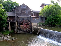
A watermill or water mill is a mill that uses hydropower. It is a structure that uses a water wheel or water turbine to drive a mechanical process such as milling (grinding), rolling, or hammering. Such processes are needed in the production of many material goods, including flour, lumber, paper, textiles, and many metal products. These watermills may comprise gristmills, sawmills, paper mills, textile mills, hammermills, trip hammering mills, rolling mills, wire drawing mills.

The Great Smoky Mountains Parkway travels 14.5 miles (23.3 km) between Great Smoky Mountains National Park and Sevierville, along U.S. Route 441 and State Route 448, in east Tennessee. It serves both, as the main thoroughfare for Gatlinburg and Pigeon Forge, and a 4.3-mile (6.9 km) spur of the Foothills Parkway.

The Sugarlands

The Sugarlands is a valley in the north-central Great Smoky Mountains, located in the Southeastern United States. Formerly home to a string of small Appalachian communities, the valley is now the location of the Great Smoky Mountains National Park headquarters and the Sugarlands Visitor Center. Lying just south of Gatlinburg, the Sugarlands is one of the park's most popular access points.

Mount Collins mountain in North Carolina, USA

Mount Collins is a mountain in the Great Smoky Mountains, located in the Southeastern United States. It has an elevation of 6,188 feet (1,886 m) above sea level. Located along the Appalachian Trail between Clingmans Dome and Newfound Gap, the mountain is a popular destination for thru-hikers. A backcountry shelter and a major trail junction are located along the mountain's northeastern slope. The mountain's summit is located amidst the Southern Appalachian spruce-fir forest that covers much of the upper elevations in the central Smokies.

Wears Valley, Tennessee Unincorporated community in Tennessee, United States

Wears Valley is an unincorporated community in Sevier County, Tennessee, treated by the U.S. Census Bureau as a census county division. As of the 2000 Census, the population of Wears Valley was 6,486.

Roaring Fork (Great Smoky Mountains)

Roaring Fork is a stream in the Great Smoky Mountains of Tennessee, located in the Southeastern United States. Once the site of a small Appalachian community, today the stream's area is home to the Roaring Fork Motor Nature Trail and the Roaring Fork Historic District.

State Route 71 is a north–south state highway in Tennessee. For most of the length it is a "hidden" route, as it coincides with US 441 in all but a short section in Knoxville. The road begins at the North Carolina state line in Sevier County within the Great Smoky Mountains National Park at Newfound Gap and ends at an intersection with US 25W, SR 116, and SR 9 (hidden) in Rocky Top. Along the length SR 71 passes through Sevier County, a small portion of Blount County, Knox County, Anderson County, and in and out of Campbell County.

Greenbrier (Great Smoky Mountains) valley in Sevier County, Tennessee

Greenbrier is a valley in the northern Great Smoky Mountains of Tennessee, located in the Southeastern United States. Now a recreational area, Greenbrier was once home to a string of Appalachian communities.

Sugarland Mountain Trail

The Sugarland Mountain Trail is an American hiking trail, in the Great Smoky Mountains National Park of Sevier County, Tennessee. The trail traverses Sugarland Mountain, a massive ridge running perpendicular to the main crest of the Smokies and effectively dividing the park's north-central section from its northwestern section. Sugarland Mountain is flanked by the deep upper valleys of two of the park's major watersheds— the West Fork of the Little Pigeon River and Little River. The trail passes through several forest types, including deciduous forest at lower elevations, heaths ("hells") along the mountain's backbone formations, and a stand of Southern Appalachian spruce-fir forest in the upper elevations. Occasional breaks in the foliage allow for views of Mount Le Conte and Sevier County to the east and Blanket Mountain and the ridges above Elkmont to the west.

Lewis Buckner was an American house builder, carpenter and furniture maker. Born and raised a slave as a child, Buckner was freed in 1865 and later apprenticed to a furniture maker. He became one of several successful African-American construction entrepreneurs in late-19th century Sevier County, Tennessee. At least fifteen homes that were either built by Buckner or are believed to have been built by Buckner are still standing, two of which are listed on the U.S. National Register of Historic Places.

Wear Cove Valley in east Tennessee, USA

Wear Cove is a valley in southwestern Sevier County, Tennessee. It runs parallel to the Great Smoky Mountains National Park just to its south. Like other park border regions, the history and economy of the valley are intertwined with that of the Smokies. The primary community is Wears Valley.

Noah Ogle Place

The Noah "Bud" Ogle Place was a homestead located in the Great Smoky Mountains of Sevier County, in the U.S. state of Tennessee. The homestead presently consists of a cabin, barn, and tub mill built by mountain farmer Noah "Bud" Ogle (1863–1913) in the late 19th century. In 1977, the homestead was added to the National Register of Historic Places and is currently maintained by the Great Smoky Mountains National Park.

Alex Cole Cabin

The Alex Cole Cabin is a historic house in Sevier County, Tennessee, United States, along Roaring Fork within the Great Smoky Mountains National Park. The last remaining building of the community of Sugarlands community proper, it was built by Albert Alexander "Alex" Cole (1870–1958). The cabin was originally located at 35°40′0″N83°31′17″W, across the Little Pigeon River from what is now the "Quiet Walkway" opposite the Huskey Gap Trailhead, just off Newfound Gap Road. After being placed on the National Register of Historic Places in the 1970s, the cabin was moved to the Jim Bales Place along the Roaring Fork Motor Nature Trail.

State Route 449 is a 6.2-mile-long (10.0 km) north–south state highway in Sevier County, within the eastern part of the U.S. state of Tennessee. It travels from US 411 overlaying Veterans Boulevard and some of Middle Creek Road in Sevierville south to US 441/US 321 (Parkway) in Pigeon Forge. It serves as a bypass around the busy tourist areas in Sevierville and Pigeon Forge.

Oude Molen, Simpelveld former watermill in Simpelveld, Netherland, Cultural heritage

The Oude Molen or Molen van Houben is a watermill located on the Oude Molenweg 6 in Simpelveld, Netherlands. Build in 1774 along the Eyserbeek river, the watermill functioned as gristmill until the 1960s. During this time it was restored several times. In 1960 the mill stopped functioning, and a year later the land upstream was disowned by the local government. Currently it functions as housing.

References

  1. 1 2 3 4 5 6 7 8 9 10 11 12 Michael Carberry, "National Registration of Historic Places Nomination Form for Pigeon Forge Mill," July 1974.
  2. J. A. Sharp, "The Historic Beginnings of Pigeon Forge." Sevier County Library History Center website. Retrieved: 2007-09-15.
  3. 1 2 3 4 5 Robbie Jones, The Historic Architecture of Sevier County, Tennessee (Sevierville, Tenn.: Smoky Mountain Historical Society, 1997), pp. 24-25, 30, 44.
  4. Pinkney Seaton, Beulah Linn (ed.), "Abstracts of the Civil War Diary of Lt. P.P. Seaton," Smoky Mountain Historical Society Newsletter 20, no. 3 (Autumn 1994): 9-16.
  5. Beulah Linn, "The West Fork of the Little Pigeon River," Smoky Mountain Historical Society Journal 22, no. 2 (Summer 1996): 3.