Related Research Articles

Orogeny is a mountain-building process that takes place at a convergent plate margin when plate motion compresses the margin. An orogenic belt or orogen develops as the compressed plate crumples and is uplifted to form one or more mountain ranges. This involves a series of geological processes collectively called orogenesis. These include both structural deformation of existing continental crust and the creation of new continental crust through volcanism. Magma rising in the orogen carries less dense material upwards while leaving more dense material behind, resulting in compositional differentiation of Earth's lithosphere. A synorogenic process or event is one that occurs during an orogeny.

A thrust fault is a break in the Earth's crust, across which older rocks are pushed above younger rocks.
Obduction is a geological process whereby denser oceanic crust is scraped off a descending ocean plate at a convergent plate boundary and thrust on top of an adjacent plate. When oceanic and continental plates converge, normally the denser oceanic crust sinks under the continental crust in the process of subduction. Obduction, which is less common, normally occurs in plate collisions at orogenic belts or back-arc basins.

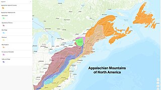
The geology of the Appalachians dates back more than 1.2 billion years to the Mesoproterozoic era when two continental cratons collided to form the supercontinent Rodinia, 500 million years prior to the development of the range during the formation of Pangea. The rocks exposed in today's Appalachian Mountains reveal elongate belts of folded and thrust faulted marine sedimentary rocks, volcanic rocks, and slivers of ancient ocean floor—strong evidences that these rocks were deformed during plate collision. The birth of the Appalachian ranges marks the first of several mountain building plate collisions that culminated in the construction of Pangea with the Appalachians and neighboring Anti-Atlas mountains near the center. These mountain ranges likely once reached elevations similar to those of the Alps and the Rocky Mountains before they were eroded.

Flysch is a sequence of sedimentary rock layers that progress from deep-water and turbidity flow deposits to shallow-water shales and sandstones. It is deposited when a deep basin forms rapidly on the continental side of a mountain building episode. Examples are found near the North American Cordillera, the Alps, the Pyrenees and the Carpathians.

The Acadian orogeny is a long-lasting mountain building event which began in the Middle Devonian, reaching a climax in the Late Devonian. It was active for approximately 50 million years, beginning roughly around 375 million years ago (Ma), with deformational, plutonic, and metamorphic events extending into the early Mississippian. The Acadian orogeny is the third of the four orogenies that formed the Appalachian Mountains and subsequent basin. The preceding orogenies consisted of the Grenville and Taconic orogenies, which followed a rift/drift stage in the Neoproterozoic. The Acadian orogeny involved the collision of a series of Avalonian continental fragments with the Laurasian continent. Geographically, the Acadian orogeny extended from the Canadian Maritime provinces migrating in a southwesterly direction toward Alabama. However, the northern Appalachian region, from New England northeastward into Gaspé region of Canada, was the most greatly affected region by the collision.

The Sevier orogeny was a mountain-building event that affected western North America from northern Canada to the north to Mexico to the south.

The Helvetic zone, Helvetic system or the Helveticum is a geologic subdivision of the Alps. The Helvetic zone crops out mainly in Switzerland, hence the name. Rocks in the Helvetic zone are sedimentary and were originally deposited at the southern margin of the European plate. The Helvetic zone correlates with the French Dauphinois zone, French geologists often prefer the French name but normally this is considered the same thing.

The Molasse basin is a foreland basin north of the Alps which formed during the Oligocene and Miocene epochs. The basin formed as a result of the flexure of the European plate under the weight of the orogenic wedge of the Alps that was forming to the south.

A foreland basin is a structural basin that develops adjacent and parallel to a mountain belt. Foreland basins form because the immense mass created by crustal thickening associated with the evolution of a mountain belt causes the lithosphere to bend, by a process known as lithospheric flexure. The width and depth of the foreland basin is determined by the flexural rigidity of the underlying lithosphere, and the characteristics of the mountain belt. The foreland basin receives sediment that is eroded off the adjacent mountain belt, filling with thick sedimentary successions that thin away from the mountain belt. Foreland basins represent an endmember basin type, the other being rift basins. Accommodation is provided by loading and downflexure to form foreland basins, in contrast to rift basins, where accommodation space is generated by lithospheric extension.

The Western Carpathians are a mountain range and geomorphological province that forms the western part of the Carpathian Mountains.

An accretionary wedge or accretionary prism forms from sediments accreted onto the non-subducting tectonic plate at a convergent plate boundary. Most of the material in the accretionary wedge consists of marine sediments scraped off from the downgoing slab of oceanic crust, but in some cases the wedge includes the erosional products of volcanic island arcs formed on the overriding plate.
The Helvetic nappes are a series of nappes in the Northern part of the Alps and part of the Helvetic zone. They consist of Mesozoic limestones, shales and marls that were originally deposited on the southern continental margin of the European continent. During the Alpine orogeny they were thrust north over a décollement and at the same time were internally deformed by folding and thrusting.

The Rhenohercynian Zone or Rheno-Hercynian zone in structural geology describes a fold belt of west and central Europe, formed during the Hercynian orogeny. The zone consists of folded and thrust Devonian and early Carboniferous sedimentary rocks that were deposited in a back-arc basin along the southern margin of the then existing paleocontinent Laurussia.

The Western Carpathians are an arc-shaped mountain range, the northern branch of the Alpine-Himalayan fold and thrust system called the Alpide belt, which evolved during the Alpine orogeny. In particular, their pre-Cenozoic evolution is very similar to that of the Eastern Alps, and they constitute a transition between the Eastern Alps and the Eastern Carpathians.

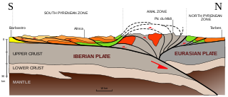
The Pyrenees are a 430-kilometre-long, roughly east–west striking, intracontinental mountain chain that divide France, Spain, and Andorra. The belt has an extended, polycyclic geological evolution dating back to the Precambrian. The chain's present configuration is due to the collision between the Iberian microcontinent and the southwestern promontory of the European plate. The two continents were approaching each other since the onset of the Upper Cretaceous (Albian/Cenomanian) about 100 million years ago and were consequently colliding during the Paleogene (Eocene/Oligocene) 55 to 25 million years ago. After its uplift, the chain experienced intense erosion and isostatic readjustments. A cross-section through the chain shows an asymmetric flower-like structure with steeper dips on the French side. The Pyrenees are not solely the result of compressional forces, but also show an important sinistral shearing.

The Carpathian Flysch Belt is an arcuate tectonic zone included in the megastructural elevation of the Carpathians on the external periphery of the mountain chain. Geomorphologically it is a portion of the Outer Carpathians. Geologically it is a thin-skinned thrust belt or accretionary wedge, formed by rootless nappes consisting of so-called flysch – alternating marine deposits of claystones, shales and sandstones which were detached from their substratum and moved tens of kilometers to the north (generally). The Flysch Belt is together with Neogene volcanic complexes the only extant tectonic zone along the whole Carpathian arc.
The geology of Sicily records the collision of the Eurasian and the African plates during westward-dipping subduction of the African slab since late Oligocene. Major tectonic units are the Hyblean foreland, the Gela foredeep, the Apenninic-Maghrebian orogen, and the Calabrian Arc. The orogen represents a fold-thrust belt that folds Mesozoic carbonates, while a major volcanic unit is found in an eastern portion of the island. The collision of Africa and Eurasia is a retreating subduction system, such that the descending Africa is falling away from Eurasia, and Eurasia extends and fills the space as the African plate falls into the mantle, resulting in volcanic activity in Sicily and the formation of Tyrrhenian slab to the north.
The geology of Austria consists of Precambrian rocks and minerals together with younger marine sedimentary rocks uplifted by the Alpine orogeny.

The Junggar Basin, also known as the Dzungarian Basin or Zungarian Basin, is one of the largest sedimentary basins in Northwest China. It is located in Dzungaria in northern Xinjiang, and enclosed by the Tarbagatai Mountains of Kazakhstan in the northwest, the Altai Mountains of Mongolia in the northeast, and the Heavenly Mountains in the south. The geology of Junggar Basin mainly consists of sedimentary rocks underlain by igneous and metamorphic basement rocks. The basement of the basin was largely formed during the development of the Pangea supercontinent during complex tectonic events from Precambrian to late Paleozoic time. The basin developed as a series of foreland basins – in other words, basins developing immediately in front of growing mountain ranges – from Permian time to the Quaternary period. The basin's preserved sedimentary records show that the climate during the Mesozoic era was marked by a transition from humid to arid conditions as monsoonal climatic effects waned. The Junggar basin is rich in geological resources due to effects of volcanism and sedimentary deposition. According to Guinness World Records it is a land location remotest from open sea with great-circle distance of 2,648 km from the nearest open sea at 46°16′8″N86°40′2″E.
References
- ↑ Ori, Gian Gabriele; Friend, Peter (1994). "Sedimentary basins formed and carried piggy-back on active thrust sheets". Geology. 12 (4): 475–478. doi:10.1130/0091-7613(1984)12<475:sbfacp>2.0.co;2.
- ↑ Wagreich M., A slope-apron succession filling a piggyback basin: the Tannheim and Losenstein Formations (Aptian - Cenomanian) of the eastern part of the Northern Calcareous Alps (Austria), University of Vienna, 2003
- Allen, Philip A. and Allen, John R. (2005) Basin Analysis: Principles and Applications, 2nd ed., Blackwell Publishing, 549 pp.
- Encyclopedia of Geomorphology, Andrew Goudie (Editor), ISBN 041527298X, Routledge, 2013