(from the mouth) ruisseau, décharge des lacs de la Vieille, Long et à Daniel, ruisseau L'Abbé, rivière aux Écorces, décharge du lac de la Boussole, décharge du lac Sable, ruisseau à la Sauce, ruisseau Dominus, ruisseau, décharge du lac Harley, bras des Angers, rivière Pika, ruisseau, ruisseau, décharge du lac Suzor-Côté, décharge du lac Scylla et du lac Charybde, rivière Apica, décharge du lac Mathias, décharge du lac Nekaw, ruisseau Côté, ruisseau, ruisseau Dicto, ruisseau Noir, ruisseau des Pies, décharge du lac des tétards, décharge du lac Argencour, ruisseau Philippe.
•right
(from the mouth) décharge du Petit lac Clair, ruisseau des Gagnon, ruisseau, décharges des lacs Caconar, ruisseau de la Blaque, ruisseau, décharge des lacs Lebeau et Vivier, Petite rivière Pikauba, décharge du lac Belvèdère, ruisseau Damasse, ruisseau Félix, ruisseau Tremblay, ruisseau Ovide, décharge du lac De Gonzague, décharge du lac Grelon et Meanwell, décharge d'un lac non identifié, décharge du lac Davenport, décharge du lac de la Grosse Truite, décharge du lac Bellemare, décharge du lac Langlois, décharge des lacs Jupiter, Violon et du Général-Tremblay.
The Pikauba River and Pikauba Lake have enjoyed a considerable reputation among hunters and fishermen since the end of the 19th century. Throughout the region, trout abounded and caribou hunting was once very popular.
The surface of the Pikauba River is usually frozen from late November to early April, however safe circulation on the ice is generally from mid-December to late March.
Geography
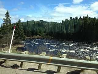
The Pikauba River is one of the most important rivers between Quebec (city) and Saguenay (city). Bordered by steep mountains, its narrow course is dotted with rapids and has several falls; it widens downstream, rich in the waters of its drainage basin which includes the Apica, Écorces, Pika and Petite Pikauba rivers. Increasingly tumultuous, it flows into the western part of Kenogami Lake.
The Pikauba River originates at the dike at the southeast mouth of Pikauba Lake which has another outlet, the Cyriac River; this other mouth is located at the bottom of a bay on the north shore. This lake is located in the central part of the Laurentides Wildlife Reserve. This lake has a length of 10.2km (6.3mi), a maximum width of 1.9km (1.2mi), an altitude is 827m (2,713ft) and an area of . This lake has a narrowing generating a strait of a hundred meters in width demarcating the northern part of the lake. The mouth of the south-east of the lake flowing into the Pikauba river is located at:
From the southeast mouth of Pikauba Lake, the Pikauba River flows over 138.8km (86.2mi), with a drop of 677m (2,221ft), according to the following segments:
Upper course of the Pikauba river (segment of 37.6km (23.4mi))
8.1km (5.0mi) south-west to the outlet (coming from the south) of lakes Jupiter, Violon and Général Tremblay, corresponding to a bend of the river located near route 175;
11.3km (7.0mi) towards the south-east along the route 175, up to Philippe stream (coming from the northeast);
5.7km (3.5mi) south along route 175, passing under the bridge of this last route, to a bend in the river;
6.9km (4.3mi) towards the north-west in a deep valley, until the stream of Hell (coming from the south);
5.6km (3.5mi) towards the northwest by collecting the Pies stream (coming from the south), to the Black stream (coming from the west);
Intermediate course of the Pikauba river, downstream from the ruisseau Noir (segment of 39.6km (24.6mi))
9.4km (5.8mi) north-west, then north, to the outlet of Davenport Lake;
5.9km (3.7mi) towards the northwest by meandering, until the Croche stream (coming from the east);
2.6km (1.6mi) westward, to Leboeuf stream (coming from the south);
7.6km (4.7mi) towards the north-west, more or less along route 169, to the Ovide stream (coming from the northeast);
9.1km (5.7mi) towards the northwest by meandering, up to Tremblay stream (coming from the southeast);
5.0km (3.1mi) north-west to a bend in the river, then west along the Félix stream, to the confluence of the Apica River (coming from South);
Intermediate course of the Pikauba river, downstream of the Apica river (segment of 35.1km (21.8mi))
8.2km (5.1mi) towards the northwest in a deep valley forming a small hook towards the east at the end of the segment, up to Damasse stream (coming from the east);
18.4km (11.4mi) towards the northwest by winding up to the Pika River (coming from the south);
8.5km (5.3mi) to the north, taking the Angers arm up to the confluence of the Petite Pikauba River (coming from the east);
Lower course of the Pikauba river (segment of 26.5km (16.5mi))
9.1km (5.7mi) towards the north by collecting the Dominus stream (coming from the west) at the start of the segment, then by collecting the Sauce stream (coming from the southwest), up to the stream at La Joke (coming from the northeast) whose confluence is located downstream from a bend in the river;
6.8km (4.2mi) north-west until the confluence of the Rivière aux Écorces (coming from the south);
2.2km (1.4mi) towards the northwest, up to ruisseau L'Abbé (coming from the southeast);
5.1km (3.2mi) towards the northeast by forming a W at the end of the segment, up to the Gagnon stream (coming from the southeast);
3.3km (2.1mi) towards the northwest, bending towards the northeast by going around a mountain, to its mouth.[1]
The Pikauba River flows into a bay on the south shore of Kenogami Lake, 1.0km (0.62mi) west of Pointe Finnigan which is attached to the south shore of the lake. This confluence of the Pikauba river is located at:
5.0km (3.1mi) west of the entrance to Épiphane Bay which is on the north shore of the lake;
The specific "Pikauba" designates two rivers and a lake in the "Laurentian wildlife reserve". Father Laure's 1731 map identifies this watercourse "Ouapikoupau river". According to Father Joseph-Étienne Guinard, in the Innu and Cree languages in particular, there is the "pikobaw" form that Father Laure translates from the Innu language as "tightened or masked by rushes". Another source claims rather that "pikobaw" breaks down into "pik", meaning "menu", "kobaw" meaning "scrub" and "wabi" meaning "white"; thus, this translation generates “white brush” or “small brush”.
In 1981, the Commission de toponymie du Québec adopted a change in the designation of this watercourse. Maps from 1900 to 1930 refer to the hydronyms "Grande Rivière Pikauba" and Petite Rivière Pikauba. The place names "Chicoutimi" and "Pikauba" officially replaced them in 1940. More recently, usage has confirmed that the part of the river south of Kenogami Lake is called "Pikauba river" and its tributary, that of “Petite rivière Pikauba”.[4]
↑ Book: Names and places of Quebec, work of the Commission de toponymie du Québec published in 1994 and 1996 in the form of a printed illustrated dictionary, and in that of a CD-ROM produced by the company Micro-Intel, in 1997, from this dictionary.
The Rivière Cyriac is a freshwater tributary feeding the Kenogami Lake, flowing in:
The Gilbert River is a freshwater tributary of the Cyriac River, flowing in the unorganized territory of Lac-Ministuk, in the Le Fjord-du-Saguenay Regional County Municipality, in the administrative region of Saguenay–Lac-Saint-Jean, in the province of Quebec, in Canada.
The Normand river is a freshwater tributary of the Cyriac River, flowing in the unorganized territory of Lac-Ministuk, in the Le Fjord-du-Saguenay Regional County Municipality, in the administrative region of Saguenay–Lac-Saint-Jean, in the province of Quebec, in Canada. The upper and intermediate course of the Normand River crosses the Laurentides Wildlife Reserve.
The Jean-Boivin River is a freshwater tributary of the Cyriac River, flowing in the unorganized territory of Lac-Ministuk, in the Le Fjord-du-Saguenay Regional County Municipality, in the administrative region of Saguenay–Lac-Saint-Jean, in province from Quebec, to Canada. The upper and intermediate course of the Jean-Boivin river crosses the Laurentides Wildlife Reserve.
The petite rivière Jean-Boivin is a freshwater tributary of the Jean-Boivin River, flowing in the unorganized territory of Lac-Ministuk, in the Le Fjord-du-Saguenay Regional County Municipality, in the administrative region of Saguenay–Lac-Saint-Jean, in province of Quebec, in Canada. The upper course of the little Jean-Boivin river crosses the Laurentides Wildlife Reserve.
The Pikauba Lake is a body of water in the watershed of the Chicoutimi River and the Saguenay River. Lac Pikauba is located in the unorganized territory of Lac-Pikauba, in the Charlevoix Regional County Municipality, in the administrative region from Capitale-Nationale, in the province of Quebec, in Canada. Pikauba Lake is located in the central part of the Laurentides Wildlife Reserve.
The Petite Rivière Pikauba is a tributary of the Pikauba River, flowing in the province of Quebec, in Canada, in the administrative regions of:
The Rivière Pika is a freshwater tributary of the Pikauba River, flowing in the administrative region of Saguenay–Lac-Saint-Jean, in the province of Quebec, in Canada. This watercourse successively crosses the regional county municipalities of:
The Apica River is a freshwater tributary of the Pikauba River, flowing in the unorganized territory of Lac-Ministuk, in the Le Fjord-du-Saguenay Regional County Municipality, in the administrative region of Saguenay–Lac-Saint-Jean, in the province of Quebec, in Canada.
Lac Mitchell is a freshwater body from the watershed of the Apica River, the Pikauba River and Saguenay River, in the unorganized territory of Lac-Jacques-Cartier, in the La Côte-de-Beaupré Regional County Municipality, in the administrative region of Capitale-Nationale, in the province of Quebec, in Canada.
Talbot Lake is a freshwater body crossed by the Petite rivière Pikauba, in the unorganized territory of Lac-Pikauba, in the Charlevoix Regional County Municipality, in the administrative region of Capitale-Nationale, in the province from Quebec, to Canada. The Talbot Lake is part of the Laurentides Wildlife Reserve.
The Bras des Angers is a tributary of the Pikauba River, flowing in the unorganized territory of Lac-Ministuk, in the Le Fjord-du-Saguenay Regional County Municipality, in the administrative region of Saguenay–Lac-Saint-Jean, in the province of Quebec, in Canada. The course of the Bras des Angers crosses the northwest part of the Laurentides Wildlife Reserve.
The ruisseau L'Abbé is a freshwater tributary of the Pikauba River, flowing in the unorganized territory of Lac-Ministuk, in the Le Fjord-du-Saguenay Regional County Municipality, in the administrative region of Saguenay–Lac-Saint-Jean, in province, in Quebec, to Canada.
The Rivière aux Écorces is a tributary of the Pikauba River, in the province of Quebec, in Canada. Its course successively crosses the regional county municipalities (MRC) of:
The Morin river is a tributary of the Rivière aux Écorces, flowing in the unorganized territory of Lac-Ministuk, in the Le Fjord-du-Saguenay Regional County Municipality, in the administrative region of Saguenay–Lac-Saint-Jean, in province from Quebec, to Canada. The course of the Morin River crosses the northwestern part of the Laurentides Wildlife Reserve.
The Rivière aux Canots is a tributary of the Rivière aux Écorces, in the province of Quebec, in Canada. Rivière aux Canots crosses the MRC of:
The Rivière aux Canots Est is a tributary of the Rivière aux Canots, flowing in the unorganized territories of Lac-Achouakan and Lac-Moncouche, the Lac-Saint-Jean-Est Regional County Municipality, in the administrative region of Saguenay–Lac-Saint-Jean, in the province of Quebec, in Canada. The course of the Rivière aux Canots Est crosses the Laurentides Wildlife Reserve.
The Rivière Trompeuse is a tributary of the rivière aux Écorces, flowing in the unorganized territory of Lac-Jacques-Cartier, in the La Côte-de-Beaupré Regional County Municipality, in the administrative region of Capitale-Nationale, in the province of Quebec, in Canada. The course of the Trompeuse River crosses the northwestern part of the Laurentides Wildlife Reserve.
The rivière aux Écorces du Milieu is a tributary of the rivière aux Écorces, flowing in the unorganized territories of Lac-Jacques-Cartier, the La Côte-de-Beaupré Regional County Municipality, in the administrative region of Capitale-Nationale, in the province from Quebec, to Canada. The course of the Rivière aux Écorces du Milieu crosses the western part of the Laurentides Wildlife Reserve.
The rivière aux Écorces North-East is a tributary of the rivière aux Écorces, flowing in the unorganized territories of Lac-Jacques-Cartier, the La Côte-de-Beaupré Regional County Municipality, in the administrative region of Capitale-Nationale, in the province of Quebec, Canada. The course of the rivière aux Écorces North-East crosses the western part of the Laurentides Wildlife Reserve.
This page is based on this Wikipedia article Text is available under the CC BY-SA 4.0 license; additional terms may apply. Images, videos and audio are available under their respective licenses.