Laguna, officially the Province of Laguna, is a province in the Philippines located in the Calabarzon region in Luzon. Its capital is Santa Cruz while its largest city is the City of Calamba and the province is situated southeast of Metro Manila, south of the province of Rizal, west of Quezon, north of Batangas and east of Cavite. Laguna hugs the southern shores of Laguna de Bay, the largest lake in the country. As of the 2020 census, the total population of Laguna is 3,382,193. Among all 82 provinces in the Philippines, Laguna accounted for the largest share (5%) of the national Gross Domestic Product (GDP) with a total of Php 990.69 billion in 2022.

Pila, officially the Municipality of Pila, is a municipality in the province of Laguna, Philippines. According to the 2020 census, it has a population of 54,613 people.

Santa Cruz, officially the Municipality of Santa Cruz, is a municipality and capital of the province of Laguna, Philippines. According to the 2020 census, it has a population of 123,574 people.

El Camino Real de Tierra Adentro, also known as the Silver Route, was a Spanish 2,560-kilometre-long (1,590 mi) road between Mexico City and San Juan Pueblo, New Mexico, that was used from 1598 to 1882. It was the northernmost of the four major "royal roads" that linked Mexico City to its major tributaries during and after the Spanish colonial era.

The architecture of the Philippines reflects the historical and cultural traditions in the country. Most prominent historic structures in the archipelago are influenced by Austronesian and American architectures.

Namayan, also called Sapa and sometimes Lamayan, was an independent polity on the banks of the Pasig River in the Philippines. It is believed to have peaked in the 11th-14th centuries, although it continued to be inhabited until the arrival of European colonizers in the 1570s.

The Spanish fortifications of the Philippines, or fuerzas, are strongholds constructed by Filipinos and Spaniards primarily for protection against local and foreign aggressors during the Spanish colonial period, and during the subsequent American and Japanese occupations. Structures built included fortresses, watchtowers, and bastions. Many are badly damaged, either due to old age or past conflicts. Currently, there are initiatives for restorations of all forts, beginning when the Baluarte Luna of La Union and the Intramuros of Manila were restored in the 2010s. In 2013, a typhoon and earthquake hit Central Visayas and damaged numerous Spanish fortifications, leading to the largest restoration activity for fortifications in Philippine history.

The Philippine Registry of Cultural Property, abbreviated as PRECUP, is a national registry of the Philippine Government used to consolidate in one record all cultural property that are deemed important to the cultural heritage, tangible and intangible, of the Philippines. On June 11, 2018, the entries in the newly updated PRECUP was at 3,921. Additionally, 1,259 out of 1,715 LGUs, or 73 percent of LGUs have established local cultural inventories (LCI).

Saint Augustine Parish Church, commonly known as Paoay Church, is a Roman Catholic church in the municipality of Paoay, Ilocos Norte in the Philippines. It is under the jurisdiction of the Diocese of Laoag. Completed in 1710, the church is famous for its distinctive architecture, a highlight of which is the enormous buttresses on the sides and back of the building. It is declared as a National Cultural Treasure by the Philippine government in 1973 and a UNESCO World Heritage Site under the collective group of Baroque Churches of the Philippines in 1993.

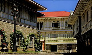
Ancestral houses of the Philippines or Heritage Houses are homes owned and preserved by the same family for several generations as part of the Filipino family culture. It corresponds to long tradition by Filipino people of giving reverence for ancestors and elders. Houses could be a simple house to a mansion. The most common ones are the "Bahay na Bato". Some houses of prominent families had become points of interest or museums in their community because of its cultural, architectural or historical significance. These houses that are deemed of significant importance to the Filipino culture are declared Heritage House by the National Historical Commission of the Philippines (NHCP), previously known as the National Historical Institute (NHI) of the Philippines. Preservation is of utmost importance as some ancestral houses have come into danger due to business people who buy old houses in the provinces, dismantle them then sell the parts as ancestral building materials for homeowners wishing to have the ancestral ambiance on their houses. These ancestral houses provide the current generation a look back of the country's colonial past through these old houses.

Northern Rio Grande National Heritage Area is a federally designated National Heritage Area in the U.S. state of New Mexico. The national heritage area includes a section of the upper Rio Grande Valley that has been inhabited by the Puebloan peoples since the early Pre-Columbian era.

The National Historical Commission of the Philippines (NHCP) and its predecessor agencies install historical markers in the Philippines and overseas to signify important and historic events, persons, sites, structures, and institutions. The commemorative plaques are permanent signs installed by the NHCP in publicly visible locations on buildings, monuments, or in special locations. The NHCP also allows local municipalities and cities to install markers of figures and events of local significance, although these markers are barred from using the seal of the Republic of the Philippines.

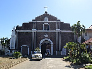
The National Shrine and Parish of San Antonio de Padua, commonly known as the Church of Pila, is a Roman Catholic national shrine dedicated to Saint Anthony of Padua in the Philippines in 1578 and the first Antonine parish church in the Philippines in 1581 and probably in Asia. It is under the jurisdiction of the Diocese of San Pablo. In 1606 the Franciscans set up the second printing press of the Philippines under the supervision of Tomás Pinpín and Domingo Loag. Its titular is Anthony of Padua, whose feast is celebrated every June 13.

Saint Andrew the Apostle Parish, commonly known as Bacarra Church, is a Roman Catholic church located in the municipality of Bacarra, Ilocos Norte, Philippines under the jurisdiction of the Diocese of Laoag.

The Malolos Historic Town Center is a historic district located in downtown Malolos City, Bulacan, Philippines, commonly called the Camestisuhan or Pariancillo District of Malolos. It was declared as such for its collection of Spanish and American-era houses and government structures, and for being the birthplace of the First Philippine Republic and the Malolos Constitution as well as having been the capital of the Philippines from 1898 to 1900. The National Historical Institute declared the downtown Malolos area officially as a National Historical Landmark and a Heritage Town on August 15, 2001.

The archaeology of the Philippines is the study of past societies in the territory of the modern Republic of the Philippines, an island country in Southeast Asia, through material culture.

The Santa Ana Heritage Zone is a portion of the district of Santa Ana, Manila, Philippines, that was declared a heritage zone in 2014 by the National Historical Commission of the Philippines (NHCP). A larger portion of district was previously declared a histo-cultural heritage/overlay zone by the city government of Manila in 2011.


