Related Research Articles

Cooper County is located in the central portion of the U.S. state of Missouri. As of the 2020 United States census, the population was 17,103. Its county seat is Boonville. The county was organized December 17, 1818, and named for Sarshell Cooper, a frontier settler who was killed by Native Americans near Arrow Rock in 1814. It is a part of the Columbia, Missouri metropolitan area.

Clark Fork Township is one of fourteen townships in Cooper County, Missouri, USA. As of the 2000 census, its population was 598.

Clear Creek Township is one of fourteen townships in Cooper County, Missouri, USA. As of the 2000 census, its population was 439.

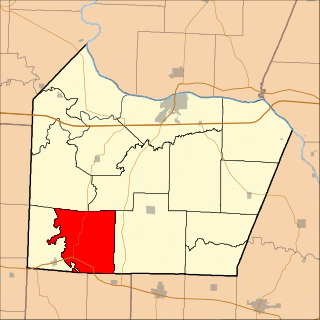
Boonville Township is one of fourteen townships in Cooper County, Missouri, USA. As of the 2000 census, its population was 9,898.

Kelly Township is one of fourteen townships in Cooper County, Missouri, USA. As of the 2000 census, its population was 676.
Lebanon Township is one of fourteen townships in Cooper County, Missouri, USA. As of the 2000 census, its population was 333.
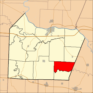
North Moniteau Township is one of fourteen townships in Cooper County, Missouri, USA. As of the 2000 census, its population was 182.

Saline Township is one of fourteen townships in Cooper County, Missouri, USA. As of the 2000 census, its population was 687.
Marion is an unincorporated community in Cole County, Missouri, United States. Marion is in the northwest corner of the county, in historic Marion Township, and very near the post-1845 county boundary line with Moniteau County. The community is located on Missouri Route 179 and overlooks the Missouri River to the east.
Moniteau Creek is a stream in Cooper, Moniteau and Cole counties in central Missouri. It is a tributary of the Missouri River. The stream headwaters are in western Moniteau County just west of Tipton. The stream flows north into Cooper County then turns east and flows through the southeastern part of the county and re-enters Moniteau County. The stream continues meandering east passing under Missouri Route 87 south of Jamestown and enters the Missouri River floodplain in the Marion Bottoms Conservation Area between Sandy Hook to the north and Marion to the south. The confluence with the Missouri River floodplain lies in the northern tip of Cole County.
Moniteau Township is an inactive township in Howard County, in the U.S. state of Missouri.
Bacon is an unincorporated community in northeast Moniteau County, in the U.S. state of Missouri. The community is on Moniteau Creek approximately seven miles northeast of California.
Pilot Branch is a stream in Moniteau County in the U.S. state of Missouri. It is a tributary of Smith Creek.
Burris Fork Township is an inactive township in Moniteau County, in the U.S. state of Missouri.
Harrison Township is an inactive township in Moniteau County, in the U.S. state of Missouri.
Linn Township is an inactive township in Moniteau County, in the U.S. state of Missouri.
Moreau Township is an inactive township in Moniteau County, in the U.S. state of Missouri.
Walker Township is an inactive township in Moniteau County, in the U.S. state of Missouri.
Moniteau Township is an inactive township in Randolph County, in the U.S. state of Missouri.
Willow Fork Township is a township in Moniteau County, in the U.S. state of Missouri.
References
- ↑ U.S. Geological Survey Geographic Names Information System: Pilot Grove Township, Moniteau County, Missouri
- ↑ "Moniteau County Place Names, 1928–1945". The State Historical Society of Missouri. Archived from the original on June 24, 2016. Retrieved November 10, 2016.
Municipalities and communities of Moniteau County, Missouri, United States | ||
|---|---|---|
| Cities |  | |
| Village | ||
| Townships | ||
| CDPs | ||
| Other communities | ||
38°32′51″N92°38′06″W / 38.5475°N 92.6350°W
| | This Moniteau County, Missouri state location article is a stub. You can help Wikipedia by expanding it. |