Oro Valley, incorporated in 1974, is a suburban town located 6 miles (9.7 km) north of Tucson, Arizona, United States, in Pima County. According to the 2010 census, the population of the town is 41,011, an increase from 29,700 in 2000. Dubbed the "Upscale Tech Mecca" of Southern Arizona by the Arizona Daily Star newspaper, Oro Valley is home to over 10 high tech firms and has a median household income nearly 50% higher than the U.S. median. The town is located approximately 110 miles (180 km) southeast of the state capital of Phoenix.
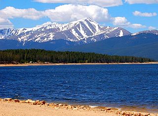
Mount Elbert is the highest summit of the Rocky Mountains, the highest point in the U.S. state of Colorado, and the second-highest summit in the contiguous United States. The ultra-prominent 14,440-foot (4401.2 m) fourteener is the highest peak in the Sawatch Range, as well as the highest point in the entire Mississippi River drainage basin. Mount Elbert is located in San Isabel National Forest, 12.1 miles (19.4 km) southwest of the City of Leadville in Lake County, Colorado.

Bridge Mountain is a mountain located in the Spring Mountain range of southern Nevada. It is located on land managed by the United States Bureau of Land Management as the Red Rock Canyon National Conservation Area, part of the Rainbow Mountain Wilderness. Bridge Mountain is named for the natural feature of a bridge-like natural arch of sandstone near the summit.

The San Gabriel Mountains are a mountain range located in northern Los Angeles County and western San Bernardino County, California, United States. The mountain range is part of the Transverse Ranges and lies between the Los Angeles Basin and the Mojave Desert, with Interstate 5 to the west and Interstate 15 to the east. The range lies in, and is surrounded by, the Angeles and San Bernardino National Forests, with the San Andreas Fault as its northern border.

The John Muir Wilderness is a wilderness area that extends along the crest of the Sierra Nevada of California for 90 miles (140 km), in the Inyo and Sierra National Forests. Established in 1964 by the Wilderness Act and named for naturalist John Muir, it encompasses 652,793 acres (2,641.76 km2). The wilderness lies along the eastern escarpment of the Sierra from near Mammoth Lakes and Devils Postpile National Monument in the north, to Cottonwood Pass near Mount Whitney in the south. The wilderness area also spans the Sierra crest north of Kings Canyon National Park, and extends on the west side of the park down to the Monarch Wilderness.

Mount San Antonio, commonly referred to as Mount Baldy or Old Baldy, is a 10,066 feet (3,068 m) summit in the San Gabriel Mountains in Los Angeles County, California. Lying within the San Gabriel Mountains National Monument and Angeles National Forest, it is the high point of the range, the county, and the Los Angeles metropolitan area. Mount San Antonio's sometimes snow-capped peaks are visible on clear days and dominate the view of the Los Angeles Basin skyline. The summit and a subsidiary peak to the west form a double-peaked high point of a steep-sided east-west ridge. The summit is accessible via a number of connecting ridges along hiking trails from the north, east, south and southwest.
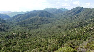
The Coronado National Forest is a United States National Forest that includes an area of about 1.78 million acres (7,200 km2) spread throughout mountain ranges in southeastern Arizona and southwestern New Mexico.

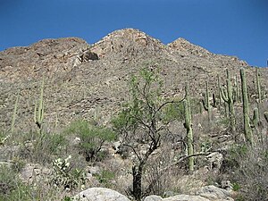
The Santa Catalina Mountains, commonly referred to as the Catalina Mountains or the Catalinas, are north and northeast of Tucson in Arizona, United States, on Tucson's north perimeter. The mountain range is the most prominent in the Tucson area, with the highest average elevation. The highest point in the Catalinas is Mount Lemmon at an elevation of 9,157 feet (2,791 m) above sea level and receives 18 inches (46 cm) of precipitation annually.

Pusch Ridge is the most prominent feature in the Pusch Ridge Wilderness Area of the Santa Catalina Mountains, managed by the Coronado National Forest north of Tucson, Arizona, in the United States.

The Tortolita Mountains are a modest mountain range northwest of Tucson, Arizona, USA, at the northern boundaries of Oro Valley and Marana, two suburbs of Tucson. Peak elevation is 4,696 feet. Much of the mountain range is protected within the Tortolita Mountain Park, established in 1986 by Pima County, which plans to expand its territory.

Catalina State Park is located at the base of the Santa Catalina Mountains. It is home to nearly 5,000 saguaros and desert plants. There are 5,500 acres of foothills and canyons that offer opportunities for camping, hiking, and bird watching. The park is home to more than 150 species. At an elevation of nearly 3,000 feet, the park offers miles of trails for recreational use.

Mount Wrightson is a 9,456-foot (2,882 m) peak in the Santa Rita Mountains within the Coronado National Forest, in southern Arizona, United States.

Mount Tom is a large and prominent peak near the city of Bishop in Inyo County of eastern California. It is in the Sierra Nevada and east of the Sierra Crest. The mountain is also in the John Muir Wilderness.

The Silver Moccasin Trail is a 53-mile (85 km) trail located in the San Gabriel Mountains, northeast of Los Angeles. It begins at Chantry Flat Recreation Area above the city of Arcadia, California, traversing upward and down through several canyons and along the high ridges of the Angeles National Forest. This trail connects Mt. Baden-Powell, Mount Burnham, Throop Peak and Mount Hawkins. It comes to its highest point of 9,399 feet (2,865 m) at Mount Baden-Powell after which point it descends to its terminus at Vincent Gap on the Angeles Crest Highway near Wrightwood.

The Sierra Madre Dam is a dam on Little Santa Anita Creek, at the mouth of Little Santa Anita Canyon, in Los Angeles County, California. It is in the San Gabriel Mountains, south of the Angeles National Forest, on the northern border of Sierra Madre.
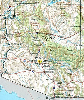
Arizona is a landlocked state situated in the southwestern region of the United States of America. It has a vast and diverse geography famous for its deep canyons, high- and low-elevation deserts, numerous natural rock formations, and volcanic mountain ranges. Arizona shares land borders with Utah to the north, the Mexican state of Sonora to the south, New Mexico to the east, and Nevada to the northwest, as well as water borders with California and the Mexican state of Baja California to the southwest along the Colorado River. Arizona is also one of the Four Corners states and is diagonally adjacent to Colorado.

The Sacatar Trail Wilderness is a federally designated wilderness area located 20 miles (32 km) northwest of Ridgecrest, California USA. It was created in 1994 with the passage of the California Desert Protection Act - Public Law 103-433 - and is managed by the Bureau of Land Management (BLM). The wilderness is 51,900 acres (210 km2) in size and protects portions of the southern Sierra Nevada Mountain Range.
The Monarch Wilderness is a federally designated wilderness area located 70 miles east of Fresno, California, in the Sierra Nevada mountain range. It encompasses 44,896 acres (181.69 km2) within both the Sequoia National Forest and the Sierra National Forest and is managed by the United States Forest Service. Elevations range from 950 feet (290 m) to 11,081 ft (3,377 m).

The Huachuca Mountains are part of the Sierra Vista Ranger District of the Coronado National Forest in Cochise County in southeastern Arizona, approximately 70 miles (110 km) south-southeast of Tucson and southwest of the city of Sierra Vista. Included in this area is the highest peak in the Huachucas, Miller Peak, and the region of the Huachucas known as Canelo Hills in eastern Santa Cruz County. The mountains range in elevation from 3,934 feet (1,199 m) at the base to 9,466 feet (2,885 m) at the top of Miller Peak. The second highest peak in this range is Carr Peak, elevation 9,200 feet (2,804 m). The Huachuca Mountain area is managed principally by the United States Forest Service (41%) and the U.S. Army (20%), with much of the rest being private land (32%). Sierra Vista is the main population center.

Millcreek Canyon is a canyon in the Wasatch Mountains and part of Millcreek City on the east side of the Salt Lake Valley, Utah. It is a popular recreation area both in the summer and in the winter. It was named by Brigham Young on August 22, 1847 before all of the mills that were built in and below the densely forested canyon. It is home to two restaurants and six Boy Scout Day Camps.