
The willow flycatcher is a small insect-eating, neotropical migrant bird of the tyrant flycatcher family native to North America.

The genus Tamarix is composed of about 50–60 species of flowering plants in the family Tamaricaceae, native to drier areas of Eurasia and Africa. The generic name originated in Latin and may refer to the Tamaris River in Hispania Tarraconensis (Spain).

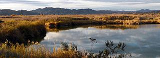
The Bosque del Apache National Wildlife Refuge is a National Wildlife Refuge located in southern New Mexico. It was founded in 1939 and is administered by the U.S. Fish and Wildlife Service. It is a favorite spot to observe sandhill cranes, which spend the fall and winter in the area. The reserve is open year-round and provides safe harbor for its varied wildlife. Visitors to the refuge also enjoy partaking in activities such as hiking, cycling, driving tours on the 12-mile scenic auto route, and participating in educational programs offered on site.

Colorado Desert is a part of the larger Sonoran Desert located in California, United States, and Baja California, Mexico. It encompasses approximately 7 million acres, including the heavily irrigated Coachella, Imperial and Mexicali valleys. It is home to many unique flora and fauna.
The Paria Canyon-Vermilion Cliffs Wilderness is a 112,500 acres (455 km2) wilderness area located in northern Arizona and southern Utah, United States, within the arid Colorado Plateau region. The wilderness is composed of broad plateaus, tall escarpments, and deep canyons.

A bosque is a type of gallery forest habitat found along the riparian flood plains of streams, river banks, and lakes. It derives its name from the Spanish word for 'forest', pronounced.

A hydrosere is a plant succession which occurs in an area of fresh water such as in oxbow lakes and kettle lakes. In time, an area of open freshwater will naturally dry out, ultimately becoming woodland. During this change, a range of different landtypes such as swamp and marsh will succeed each other.

A riparian zone or riparian area is the interface between land and a river or stream. In some regions, the terms riparian woodland, riparian forest, riparian buffer zone, riparian corridor, and riparian strip are used to characterize a riparian zone. The word riparian is derived from Latin ripa, meaning "river bank".

The San Pedro River is a northward-flowing stream originating about 10 miles (16 km) south of the international border south of Sierra Vista, Arizona, in Cananea Municipality, Sonora, Mexico. The river starts at the confluence of other streams just east of Sauceda, Cananea. Within Arizona, the river flows 140 miles (230 km) north through Cochise County, Pima County, Graham County, and Pinal County to its confluence with the Gila River, at Winkelman, Arizona. It is the last major, undammed desert river in the American Southwest, and it is of major ecological importance as it hosts two-thirds of the avian diversity in the United States, including 100 species of breeding birds and almost 300 species of migrating birds.

A riparian buffer or stream buffer is a vegetated area near a stream, usually forested, which helps shade and partially protect the stream from the impact of adjacent land uses. It plays a key role in increasing water quality in associated streams, rivers, and lakes, thus providing environmental benefits. With the decline of many aquatic ecosystems due to agriculture, riparian buffers have become a very common conservation practice aimed at increasing water quality and reducing pollution.
The biogeoclimatic zones of British Columbia are units of a classification system used by the British Columbia Ministry of Forests for the Canadian province's fourteen different broad, climatic ecosystems. The classification system, termed Biogeoclimatic Ecosystem Classification, exists independently of other ecoregion systems, one created by the World Wildlife Fund and the other in use by Environment Canada, which is based on one created by the Commission for Environmental Cooperation (CEC) and also in use by the US Environmental Protection Agency (EPA). The system of biogeoclimatic ecosystem classification was partly created for the purpose of managing forestry resources, but is also in use by the British Columbia Ministry of Environment and Climate Change Strategy and other provincial agencies. A biogeoclimatic zone is defined as "a geographic area having similar patterns of energy flow, vegetation and soils as a result of a broadly homogenous macroclimate."

Tamarix ramosissima, commonly known as saltcedarsalt cedar, or tamarisk, is a deciduous arching shrub with reddish stems, feathery, pale green foliage, and characteristic small pink flowers.
The Imperial National Wildlife Refuge protects wildlife habitat along 30 miles (50 km) of the lower Colorado River in Arizona and California, including the last un-channeled section before the river enters Mexico. The Imperial Refuge Wilderness, a federally designated, 15,056-acre (60.93 km2), wilderness area is protected within the refuge. It also surrounds the Picacho State Recreation Area. This section of the Colorado River is popular for boating, hiking, fishing, camping, exploring old mining camps and wildlife watching.

The Bill Williams River National Wildlife Refuge protects the lower course of the Bill Williams River, to its mouth at Lake Havasu reservoir, in western Arizona. It is located within eastern La Paz and Mohave Counties, in the Lower Colorado River Valley region.
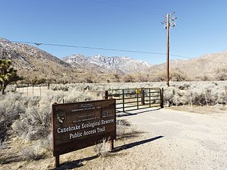
Canebrake Ecological Reserve is a 6,700-acre (27 km2) nature reserve in the South Fork Valley of Kern County, 20 miles (32 km) east of Lake Isabella, California. It is located in the Southern Sierra Nevada region.

Riparian-zone restoration is the ecological restoration of riparian-zonehabitats of streams, rivers, springs, lakes, floodplains, and other hydrologic ecologies. A riparian zone or riparian area is the interface between land and a river or stream. Riparian is also the proper nomenclature for one of the fifteen terrestrial biomes of the earth; the habitats of plant and animal communities along the margins and river banks are called riparian vegetation, characterized by aquatic plants and animals that favor them. Riparian zones are significant in ecology, environmental management, and civil engineering because of their role in soil conservation, their habitat biodiversity, and the influence they have on fauna and aquatic ecosystems, including grassland, woodland, wetland or sub-surface features such as water tables. In some regions the terms riparian woodland, riparian forest, riparian buffer zone, or riparian strip are used to characterize a riparian zone.

The Gardena Willows Wetland Preserve occupies 13.6 acres (55,000 m2) of land owned by the City of Gardena, in Los Angeles County, California. The preserve is the last intact remnant of the former Dominguez Slough, an important vernal marsh and riparian forest with riparian zones that once covered as much as 400 acres (1,600,000 m2) of this area, known as the South Bay region. The preserve has 9.4 acres (38,000 m2) of wetland and 4.2 acres (17,000 m2) of upland. The wetlands have a natural depression where water remains for such a significant time that plants and animals not adapted to water and saturated soils cannot survive. The upland, which remains dry outside of the rainy season, supports plants which thrive with these drier conditions. The slough is a part of the Dominguez Watershed, 96% of which is now covered with concrete and man-made structures. Located on the traditional lands of the Tongva, it is believed that these indigenous people were able to commute by canoe around much of the area. Tongva villages were located throughout much of what is now Los Angeles and Orange Counties as well as three southern Channel Islands as distant as 60 miles (97 km) from the coast of Los Angeles County.
The West Wetlands Park is a public city park in the northwest edge of Yuma, Arizona. It is located along the Colorado River within the Yuma Crossing National Heritage Area. The park opened in December of 2002 on 110 acres of city-owned land. It was partially constructed by community volunteers. The West Wetlands Park is currently managed by a non-profit organization, the Yuma Crossing National Heritage Area Corporation, and is maintained by the City of Yuma Parks and Recreation Department.

Flora of the Colorado Desert, located in Southern California. The Colorado Desert is a sub-region in the Sonoran Desert ecoregion of southwestern North America. It is also known as the Low Desert, in contrast to the higher elevation Mojave Desert or High Desert, to its north.

The Hassayampa River Preserve is a 770-acre riparian nature reserve owned by The Nature Conservancy in the US state of Arizona, near Wickenburg in Maricopa County. The Hassayampa River has mostly subterranean flows for most of its 113 miles (182 km) length, the stretch contained within the preserve has year-round flowing water.

