
Yavapai County is near the center of the U.S. state of Arizona. As of the 2020 census, its population was 236,209, making it the fourth-most populous county in Arizona. The county seat is Prescott.

Mingus Mountain is a mountain located in the U.S. state of Arizona in the Black Hills mountain range. It is located within the Prescott National Forest traversed by State Route 89A approximately midway between Cottonwood and Prescott. The summit can be reached via Forest Service roads that branch off from State Route 89A. From the mountain, there are views of the Verde Valley, Sycamore Canyon Wilderness and the towns of Cottonwood, Jerome, and Clarkdale. The Woodchute Wilderness, north of the summit of 89A, also offers views and hiking trails. There are several National Forest campgrounds in the area and it is the transmitter location for Prescott full-service television station KAZT-TV and several low-power television stations serving Cottonwood, Clarkdale, Camp Verde and Prescott Valley. Mingus Mountain is also the premier flying site of the Arizona Hang Gliding and Paragliding Association.

The Tonto National Forest, encompassing 2,873,200 acres, is the largest of the six national forests in Arizona and is the fifth largest national forest in the United States. The forest has diverse scenery, with elevations ranging from 1,400 feet in the Sonoran Desert to 7,400 feet in the ponderosa pine forests of the Mogollon Rim. The Tonto National Forest is also the most visited "urban" forest in the United States.

The Coconino National Forest is a 1.856-million acre United States National Forest located in northern Arizona in the vicinity of Flagstaff. Originally established in 1898 as the "San Francisco Mountains National Forest Reserve", the area was designated a U.S. National Forest in 1908 when the San Francisco Mountains National Forest Reserve was merged with lands from other surrounding forest reserves to create the Coconino National Forest. Today, the Coconino National Forest contains diverse landscapes, including deserts, ponderosa pine forests, flatlands, mesas, alpine tundra, and ancient volcanic peaks. The forest surrounds the towns of Sedona and Flagstaff and borders four other national forests; the Kaibab National Forest to the west and northwest, the Prescott National Forest to the southwest, the Tonto National Forest to the south, and the Apache-Sitgreaves National Forest to the southeast. The forest contains all or parts of ten designated wilderness areas, including the Kachina Peaks Wilderness, which includes the summit of the San Francisco Peaks. The headquarters are in Flagstaff. There are local ranger district offices in Flagstaff, Happy Jack, and Sedona.

The Prescott National Forest is a 1.25 million-acre United States National Forest located in north central Arizona in the vicinity of Prescott. The forest is located in the mountains southwest of Flagstaff and north of Phoenix in Yavapai County, with a small portion extending into southwestern Coconino County.

Kendrick Peak or Kendrick Mountain is one of the highest peaks in the San Francisco volcanic field north of the city of Flagstaff in the U.S. State of Arizona and is located on the Coconino Plateau in Coconino County.

Sycamore Canyon is the second largest canyon in the Arizona redrock country, after Oak Creek Canyon. The 21-mile (34 km) long scenic canyon reaches a maximum width of about 7 miles (11 km). It is in North Central Arizona bordering and below the Mogollon Rim, and is located west and northwest of Sedona in Yavapai and Coconino counties.

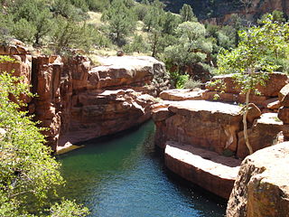
Sycamore Canyon Wilderness is a 56,000-acre wilderness area in the Coconino, Kaibab and Prescott national forests in the U.S. state of Arizona. Encompassing Sycamore Canyon and its surrounds from south of Williams to the confluence of Sycamore Creek with the Verde River, the wilderness is about 40 miles (64 km) southwest of Flagstaff. The canyon is one of several in Arizona that cut through the Mogollon Rim. Relevant United States Geological Survey (USGS) map quadrangles are Davenport Hill, White Horse Lake, May Tank Pocket, Perkinsville, Sycamore Basin, and Clarkdale. Red Rock-Secret Mountain Wilderness borders Sycamore Canyon Wilderness on the east.
Wet Beaver Wilderness is a 6,155-acre wilderness area located in the Coconino National Forest in the U.S. state of Arizona.

The Mazatzal Mountains are a mountain range in south central Arizona, about 30–45 miles northeast of Phoenix and the Phoenix metropolitan area. The origin of the name remains obscure but one possibility is that it is from the Nahuatl language meaning "place of the deer". The crest of the Mazatzals forms the county line between Maricopa County and Gila County. SR 87, the Beeline Highway, traverses the Mazatzals on its way to Payson. The highest peak is Mazatzal Peak at 7,903 feet (2,409 m). They also include the Four Peaks, with elevation 7,659 ft, 2,334 m; a prominent mountain and landmark of the eastern Phoenix area.
Apache Creek Wilderness is a 5,666-acre wilderness area under the jurisdiction of the Chino Valley District of the Prescott National Forest in the U.S. state of Arizona. Established in 1984, the Wilderness contains rolling hills of juniper and pinyon pine, outcroppings of granite, three natural springs, and several important riparian areas including Apache Creek. Elevations range from 5,280 feet to 6,970 feet, and the area provides excellent habitat for mountain lion and numerous bird species.
Pine Valley Mountain Wilderness is a 50,232-acre (203.28 km2) wilderness area located in the Dixie National Forest in the U.S. state of Utah. It is the fourth-largest wilderness area located entirely within the state. The wilderness designation protects the Pine Valley Mountain range, a large rock outcrop surrounded by desert. The Pine Valley Mountains form the Pine Valley Laccolith, one of the largest laccoliths in the United States. Elevations in the wilderness range from 6,000 feet (1,800 m) to 10,365 feet (3,159 m) at the summit of Signal Peak.
The Black Hills of Yavapai County are a large mountain range of central Arizona in southeast Yavapai County. It is bordered by the Verde Valley to the east. The northwest section of the range is bisected from the southeast section by Interstate 17, which is the main route connecting Phoenix to Sedona, Oak Creek Canyon, and Flagstaff. This bisection point is the approximate center of the mostly northwest by southeast trending range. The northwest section contains a steep escarpment on the northeast with the Verde Valley, the escarpment being the location of the fault-block that created the historic mining district at Jerome. The United Verde Mine was one of the largest copper mines in the United States, producing large quantities of copper, gold, silver and zinc.

Woodchute Wilderness is a 5,923-acre wilderness area in Prescott National Forest in the U.S. state of Arizona. It is about 4 miles west of the town of Jerome. Elevation within the area, on the flanks of Woodchute Mountain, ranges from 5,500 feet to 7,800 feet. A chute on the north side of the mountain helped transport wood to historic Jerome.
Mazatzal Wilderness is a wilderness area of about 390 square miles (1,000 km2) in Yavapai and Gila counties in the U.S. state of Arizona. The wilderness is within the Tonto and Coconino national forests. The town of Payson is to the east, and the Verde River is to the west. During summer, temperatures in the wilderness often exceed 110 °F (43 °C).
Munds Mountain Wilderness is an 18,150-acre wilderness area in the Coconino National Forest in the U.S. state of Arizona. It is immediately southeast of Sedona between Arizona State Route 179 and Interstate 17. The wilderness lies within the Munds Mountain and Sedona quadrangles of the national topographic map of the United States Geological Survey.
Juniper Mesa Wilderness is a 7,406-acre wilderness area in the Prescott National Forest in the U.S. state of Arizona. The mesa is about an hour's drive northwest of Prescott in the Juniper Mountains of Yavapai County. The wilderness varies in elevation from 5,600 to 7,000 feet. It is entirely within the Juniper Mountain quadrangle of the United States Geological Survey (USGS) topographic map.
Castle Creek Wilderness is a protected wilderness area in the Prescott National Forest in the U.S. state of Arizona. Established in 1984, the Wilderness lies within the southern end of the rugged Bradshaw Mountains. Elevations range from 2,800 feet to 7000 feet, allowing for a range of vegetation. Saguaro cactus, palo verde, and mesquite dominate the lower end of the range in the south, as the elevation increases the vegetation changes to a chaparral community and further north in the highest elevations includes ponderosa pine, Arizona oak, and alligator juniper.
Cedar Bench Wilderness is a protected wilderness area in the Prescott National Forest in the U.S. state of Arizona. Established in 1984 under the Arizona Wilderness Act, the area protects the large "bench" that divides the Agua Fria and Verde River drainages. Elevations range from 4,500 feet to 6,700 feet with vegetation that includes saguaro cactus along the Verde river to chaparral to smaller amounts of pinyon pine and Utah juniper along the high points.
