Related Research Articles

Sausalito is a city in Marin County, California, United States, located 1.5 miles southeast of Marin City, 8 miles (13 km) south-southeast of San Rafael, and about 4 miles (6 km) north of San Francisco from the Golden Gate Bridge.

Tiburon is an incorporated town in Marin County, California. It is located on the Tiburon Peninsula, which reaches south into the San Francisco Bay. It shares a ZIP code with the smaller incorporated city of Belvedere, which occupies the southwest part of the peninsula and is contiguous with Tiburon. Tiburon is bordered by Corte Madera to the north and Mill Valley to the west, but is otherwise mostly surrounded by the bay. Besides Belvedere and Tiburon, much of the peninsula is unincorporated, including portions of the north side and the communities of Strawberry and Paradise Cay.

Marin City is an unincorporated community and census-designated place (CDP) in Marin County, California, United States. As of the 2020 census, it had a population of 2,993, up from 2,666 in 2010. It is located 1.5 miles northwest of downtown Sausalito, 8 miles (13 km) south-southeast of San Rafael, and about 5 miles (8 km) north of San Francisco from the Golden Gate Bridge, at an elevation of 23 feet (7.0 m). Marin City was developed for housing starting in 1942, to accommodate wartime shipyard workers and other migrants to California. Among those were African Americans from the South in the Great Migration, which continued until 1970.

The Sierra Ancha is a mountain range in Gila County, in central Arizona. It lies between Roosevelt Lake to the south, the Tonto Basin to the west, Cherry Creek to the east, and Pleasant Valley to the north. The range is one of several, including the Bradshaw Mountains, Mingus Mountain of the Black Hills, and the Mazatzal Mountains, which form a transitional zone between the lowland deserts of southern Arizona and the Colorado Plateau of northeastern Arizona. The highest point in the range is Aztec Peak, at an elevation of 2345 m (7694 ft).
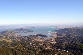
Richardson Bay is a shallow, ecologically rich arm of San Francisco Bay, managed under a Joint Powers Agency of four northern California cities. The 911-acre (369 ha) Richardson Bay Sanctuary was acquired in the early 1960s by the National Audubon Society. The bay was named for William A. Richardson, early 19th century sea captain and builder in San Francisco. It contains both Strawberry Spit and Aramburu Island.

Marinship Corporation was a shipbuilding company of the United States during World War II, created to build the shipping required for the war effort. Founded in 1942, the shipyard built 93 cargo ships and oil tankers, before ending operations in 1945.

The Hyde Street Pier, at 2905 Hyde Street, is a historic ferry pier located on the northern waterfront of San Francisco, California.
Schoonmaker Point is a low-lying landform jutting into San Francisco Bay at Sausalito, California. This area was created by dredge spoils from Richardson Bay during local Marin Shipyards shipbuilding activity during World War II. Schoonmaker Point is situated approximately 1.7 miles (2.7 km) south of the Sausalito/Marin City interchange of U.S. Highway 101 immediately north of Bridgeway Boulevard. The Schoonmaker Point Marina is located here, along with a 2.3-acre (9,300 m2) sand beach.. From Schoonmaker Point there are views of Mount Tamalpais and the San Francisco downtown skyline.

Oakland Point, or Gibbons' Point, was a small promontory formerly on the eastern shore of San Francisco Bay in West Oakland, California. It was located in the vicinity of what is now the Port of Oakland shipping terminal.

Strawberry Lagoon is an inlet within Richardson Bay, Marin County, California, United States. This location, particularly on Strawberry Spit, is a winter haul-out area for the Harbor seal. Pressures of urban development at Strawberry Point along with increases in small boat traffic have diminished the use of this lagoon for seal haul out, noted as early as 1990.

The Spaulding Marine Center, , in Sausalito, California, is a living museum where one can go back in time to experience the days when craftsmen and sailors used traditional skills to build, sail or row classic wooden boats on San Francisco Bay.
Bothin Marsh is a 106 acres (43 ha) wetland in Marin County, California. Parts of the wetlands are in the Bothin Marsh Open Space Preserve, a regional park.
The Raccoon Strait is a waterway of the San Francisco Bay between Angel Island and the Tiburon Peninsula, mainland Marin County, California, United States. During the ice ages, when sea levels were considerably lower and San Francisco Bay was a grassy valley, the combined Sacramento-San Joaquin river flowed through what is now Raccoon Strait before flowing through the canyon at the Golden Gate.

The Tiburon Peninsula is a landform of the San Francisco Bay Area's Marin County and is home to the incorporated municipalities of Tiburon, Belvedere, and a portion of Corte Madera, California. Much of the peninsula is unincorporated, including portions of the north side and the communities of Paradise Cay and Strawberry. Richardson Bay separates the peninsula from the Marin County mainland. Angel Island lies app. 1 mile south of the peninsula's southern tip. Much of the land area of the Tiburon Peninsula was part of a Spanish land grant originally given to the early Californian John Reed. A prominent feature of the Tiburon Peninsula is Ring Mountain, Marin County, which forms the backbone of the peninsula and is the highest elevation of the peninsula. The Tiburon Peninsula is the location of a number of rare and endangered flora species, and is also the site of ancient Native American rock carvings. The mineral lawsonite was first described from an occurrence on the Tiburon Peninsula.

Oakland Hills is an informal term used to indicate the city neighborhoods lying within the eastern portion of Oakland, California. The northernmost neighborhoods were devastated by the Oakland firestorm of 1991.

Triangle Marsh is a wetland of the San Francisco Bay, situated at the base of Ring Mountain at the north end of the Tiburon Peninsula in Marin County, California.
Fallon, California is an unincorporated community in Marin County, California Just west of State Route 1 along the abandoned North Pacific Coast Railroad.
Tamalpais Valley is an unincorporated community in Marin County, California.
Madden, Lewis or Madden and Lewis Company or Madden and Lewis Corp. was a wooden shipbuilding company in Sausalito, California. To support the World War 2 demand for ships Madden, Lewis shipyard switched over to military construction and built: US Navy tugboats and Harbour Defence Motor Launch. The company was founded by James Herbert Madden Sr., who was also active in the Sausalito Yacht Club. James Herbert Madden Sr. and Gertrude Murphy Madden raised five children in Sausalito. Madden and Lewis Company also owned the Sausalito side of the Golden Gate Ferry Company that ran before the completion of the Golden Gate Bridge, the ferry was run by the Northwestern Pacific Railroad now the site of the Sausalito Ferry Terminal. After the war the yard returned to pleasure craft building and repair. On March 19, 1960 a large fire broke out at the boatyard. The boatyard was in Richardson Bay at 200 Johnson street, Sausalito, near the current Sausalito Yacht Harbor.
Sausalito Shipbuilding in Sausalito, California, started in 1942 as the Oakland shipbuilding Corporation. The founders had hoped to start a new shipyard in Oakland, California, but a better site opened up next to the new Marinship shipyard in Sausalito, which built Liberty ships. The site was near the former Northwestern Pacific Railroad repair yard situated at Richardson's Bay in Marin County. With World War II underway, there was a demand for more vessels, Oakland and much of the San Francisco Bay was also already built up. The shoreline in Marin County had open space to built new shipyards. At the site, the new company built 4 shipways. It had no official name while it was being built but was referred to as the "Marin Shipbuilding Division of W.A. Bechtel Company" and that lengthy title was shortened to Marin-Ship or what known today as "Marinship" with a street in Sausalito named Marinship Way. Sausalito Shipbuilding received a US Army contact to built barges. Sausalito Shipbuilding was operated as Co-Operative, each worker having a share in the company. The president was D. F. Baker, who had worked at Mare Island Naval Shipyard, Brooklyn Navy Yard and Bremerton Navy Yard. The vice president was R. E. Oberer. Tresurer was Ernent Collins. Office manager was E. G. Harris. The other key partner was Robert Rich and Stanley G. Morris. Stanley G. Morris sold his share to Rich in August 1945. The site was north end of Sausalito, California and just three miles (5 km) north of the Golden Gate Bridge. Ernent Collins was a yacht builder for years before the joining the partnership. Later Robert Rich became the president of Sausalito Shipbuilding. Later he sold his share in the company and joining a Dredging Company that worked with Sausalito Shipbuilding. Robert Rich sold his shares Gus Wandtke and Ernest Collins. In 1945 with the end of World War 2, like many shipyard, Sausalito Shipbuilding closed. There was surplus of ships after the war. The site later became Sausalito houseboat community.
References
- C. Michael Hogan. 2008. Ring Mountain, The Megalithic Portal, ed. Andy Burnham
- Railroading in California circa 1900
- Pine Point — Sausalito’s Lost Community
Coordinates: 37°51′54″N122°29′47″W / 37.8649°N 122.4963°W
| | This Marin County, California–related article is a stub. You can help Wikipedia by expanding it. |